Williamsburg Lodge Tazewell Wing Archaeological Report, Block 44-1 Building 3KOriginally entitled: "Archaeological Excavations on the Tazewell Hall Property"
Colonial Williamsburg Foundation Library Research Report Series - 1301
Colonial Williamsburg Foundation Library
Williamsburg, Virginia
1990
 Front Elevation
ARCHAEOLOGICAL EXCAVATIONS ON THE TAZEWELL HALL PROPERTY
Department of Archaeology
Office of Archaeological Excavation
Colonial Williamsburg Foundation
Marley R. Brown III
Principal investigator
ARCHAEOLOGICAL EXCAVATIONS ON THE TAZEWELL HALL PROPERTY
Department of Archaeology
Office of Archaeological Excavation
Colonial Williamsburg Foundation
Marley R. Brown III
Principal Investigator
May 15, 1986
Williamsburg Lodge Tazewell Wing Archaeological Report Block 44-1 Building 3K
Title page -
Marley R. Brown III
Principal Investigator
May 15,1986
2 - The salvage excavation at the Tazewell Hall site took place between June 25 and November 12, 1984.
8 - Sir John Randolph died on March 9, 1736/7
9 - In November, 1762 ten acres of this property, fronting on England Street ....
12 - By June 1775, Lord Dunmore reported that ...
12 -. . . they have been persuaded to go" (Dunmore to Dartmouth, September 24 [PRO, GO 5-1353])
12 - In October of 1775, Peyton Randolph, acing on his brother John's behalf. . .
12 - The sale was delayed until July of 1778 ....
12 - According to the Virginia Gazette of July 17, 1778 ....
12 -. . All of these were made before the 15th of October.
16 - Mutual Assurance Policy No. 17655
November 14, 1853
19 - The first archaeological report on the site was the description of a utility trench cut longside South England Street on February 23, 1934
29 - Excavation of the site took place between June 25 and November 12, 1984.
1 - 1 THIS IDENTURE
made the twenty fifth Day of August in the year of our Lord one thousand seven hundred and seventy five ....
1 - 4 At a court held for James City County August the eleventh, 1777.
2- 6 - 1830, May 20th
Mutual Assurance Policy #7601 Revaluation of the Building declared ....
2- 8 -Mutual assurance Policy #14391 .... 1846, October 3rd.
2 - 9 - assurance by Joshua Walker per declaration #17655 1860, [no month or day]
3 - 3 DATE BEGUN 06/25/84 END 06/25/84
Elknah Deane House Archaeological Report, Block 30-2 Building 1A
Title page
Gregory J. Brown
Office of Archaeological Excavation
Colonial Williamsburg Foundation
May 28, 1985
1 - (Letter from Edward P. Alexander to Cocke, Kendrew, Graham, and Harbour, November 20, 1962)
2 - . . . from three research reports (Bullock 1931; McWilliams 1944; Stephenson 1956).
4 - The first known mention of this property was in 1720.
3 -. . . appears on a 1759 deed transferring the land to Carter.
4 - Dr. Carter mortgaged his property in June 1767
4 - Dr. Carter offered his house for sale (Virginia Gazette, Purdie & Dixon, December 15, 1768)
5 -. . . for his Excellency the Right Honourable the Earl of Dunmore " (Virginia Gazette, William Rind, June 17,1772).
5 - "the Palace Street Puffer" (Virginia Gazette, Clementina Rind, October 28; November 11; November 18; December 2, 1773)
5 - And on Tuesday the 7th of the next month will be sold ....
6 - Elizabeth Deane died by 1797, nd the house apparently disappeared by 1806.
7 - James Knight (pers. Comm. 1985) believes that the. . .
15 -... was vigorously debated in the 1930s.
16 Foundations uncovered by Archaeological Excavation, August 1931.
ABSTRACT
Salvage archaeological excavations were conducted by the Colonial Williamsburg Foundation's Office of Archaeological Excavation on the former location of Tazewell Hall from June through November, 1984.
Tazewell Hall, the 18th-century residence of John Randolph, was constructed sometime around 1762. This H-shaped mansion, located at the southern end of South England Street, was one of the most visually impressive structures in Williamsburg, rivaled in size only by the Governor's Palace. In 1778, the property was sold to John Tazewell, within whose family it remained until the 1840s. In 1908 or 1909, the house was moved from its original foundations to another part of the property, in order to make way for an extension of South England Street. There it stood until 1954, when it was sold, torn down, and later reconstructed to its original 18th century appearance in Newport News, Virginia.
Although the Colonial Williamsburg Foundation had conducted previous archaeological investigations on the property in 1948, the 1984 excavations focused on a different aspect of the Tazewell Hall site. These excavations, under the supervision of James M. Knight, while locating the main house and its west wing, had concentrated on excavating the outbuildings situated on the eastern portion of the property. The 1984 excavations were to focus along the western half of the property, the area to be impacted by the new guest facilities. Here, the excavation was hoped to reveal the remains of the reputedly extensive formal gardens constructed by John Randolph. Also of interest was the location and excavation of outbuildings depicted on various 18th and 19th century maps and insurance records, as well as sampling of the cellar fill of the west wing, whose destruction dated to 1835.
The majority of the area salvaged was located under what was, at that time, the south parking lot of the Williamsburg Lodge. Mechanical stripping of the asphalt paving and sand base revealed that all cultural soil stratigraphy had been destroyed during the parking lot construction. Thus, no remains of outbuildings were located by the excavations at the rear of the house, and only features which cut into the sterile subsoil remained. Various features relating to the formal gardens of Tazewell Hall were located, as well as two features which could possibly represent disinterred human graves.
A boundary ditch located along the western edge of the property, filled between 1775 and 1778, provided a terminal deposit with which to analyze behavior associated with the abandonment of the property'. The artifact assemblage from the iii ditch was not an accurate reflection of the Randolph's material possessions, reflecting instead the particular events associated with his departure and the subsequent activities occurring on the site before re-occupation. The assemblage included a large number of utilitarian wares probably discarded at the time that the property was sold in 1778, as well as a variety of secondary refuse more representative of a household assemblage, and most likely generated through yard cleaning.
Sampling within the west wing cellar fill produced a valuable assemblage of late 18th to mid-19th century ceramics and glass, which was probably associated with the occupants of the property between the death of Littleton Tazewell in 1815 and its purchase by Dickie Galt in 1835. Included in the ceramic tableware assemblage were a variety of edged wares, ranging from creamwares popular in the 1770s to whitewares with embossed motif s whose production began in the 1820s. It is known that overseer William Ball resided at the house during the early 1820s, and that the property was most likely rented between his tenancy and its 1835 sale. Through a time lag study and other analysis, characteristics of the assemblage were linked to the property's occupants during this period, and were seen as indicative of -their economic and social status. The unusual nature of the cellar deposit was then seen not as a typical terminal deposit, but as an accumulated mixture of renter's possessions left in the house for several years.
iv 1898 Photograph
| LIST OF FIGURES | vii |
| LIST OF TABLES | ix |
| PHOTO AND ILLUSTRATION CREDITS | x |
| ACKNOWLEDGMENTS | xi |
| CHAPTER 1. INTRODUCTION | 1 |
| CHAPTER 2. PROPERTY HISTORY | 7 |
| CHAPTER 3. PREVIOUS ARCHAEOLOGY | 19 |
| CHAPTER 4. FIELD AND LABORATORY METHODS | |
| Field Methods | 29 |
| Laboratory Methods | 33 |
| CHAPTER 5. ARCHAEOLOGICAL RESULTS | |
| Main House/West Wing | 35 |
| Testing in the Front Yard | 59 |
| Boundary Ditch | 69 |
| Fence Lines | 75 |
| Garden Features | 79 |
| CHAPTER 6. ARTIFACTS by Ann M. Smart & William Pittman | 105 |
| CHAPTER 7. CONCLUSION | 143 |
| CHAPTER 8. BIBLIOGRAPHY | 155 |
| APPENDIX 1. JOHN RANDOLPH'S DEED OF TRUST | 1-1 |
| APPENDIX 2. MUTUAL ASSURANCE SOCIETY PLATS | 2-1 |
| APPENDIX 3. SAMPLE CONTEXT RECORD FORM | 3-1 |
| APPENDIX 4. MASTER CONTEXT RECORD | 4-1 |
| APPENDIX 5. UNIQUE VESSEL CATALOGUE | 5-1 |
| APPENDIX 6. SHERD SIZE TESTING PROCEDURE | 6-1 |
| APPENDIX 7. FAUNAL ANALYSIS by Nancy Demetropolis | 7-1 |
| APPENDIX 8. REPORT ON INFANT REINTERMENT | 8-1 |
| APPENDIX 9. PALYNOLOGICAL AND PARASITOLOGICAL INVESTIGATIONS by Karl Reinhard | 9-1 |
Spec Coll RR1301
vii| Figure 1.Location of the Tazewell Hall property | 3 |
| Figure 2.1984 excavation area | 5 |
| Figure 3.Plan of 18th-century Tazewell Hall | 10 |
| Figure 4.Desandrouins Map showing Tazewell property | 11 |
| Figure 5.1853 Mutual Assurance Society policy | 16 |
| Figure 6.Features uncovered by James Knight, Oct-Nov 1948 | 21 |
| Figure 7.West foundation wall of main house | 22 |
| Figure 8.Bulkhead entrance to west wing cellar | 24 |
| Figure 9.Foundation of dairy | 25 |
| Figure 10.Foundation of laundry/kitchen | 26 |
| Figure 11.Location of units in-north yard | 30 |
| Figure 12.Isometric profile of west wing cellar fill | 38 |
| Figure 13.Profile of west passageway | 39 |
| Figure 14.1984 excavation area superimposed on plan of west wing | 46 |
| Figure 15.Total artifact distribution of cellar floor | 47 |
| Figure 16.Wine bottle glass and ceramic distributions from cellar floor | 48 |
| Figure 17.Window glass and nail distributions from cellar floor | 49 |
| Figure 18.L-shaped brick sill | 55 |
| Figure 19.Lightning rod | 56 |
| Figure 20.Property boundary and outbuilding shown on Frenchman's Map | 60 |
| Figure 21.Location of-18th century features in front yard. 61 Location of 19th century features in front yard. | 61 |
| Figure 22.Location of 19th century features in front yard | 63 |
| Figure 23A.Finger trailed annular pearlware | 64 |
| Figure 23B.Pewter spoon marked "W (m.) MIX" | 64 |
| Figure 24.Location of marl walkway in front yard. | 65 |
| Figure 25.1724 British halfpenny found in marl walkway | 66 |
| Figure 26.Boundary ditch | 70 |
| Figure 27.Williamsburg, VA: South View showing Tazewell Hall | 74 |
| Figure 28.Fence lines | 76 |
| Figure 29.Detail of Frenchman's Map showing Tazewell Hall garden | 80 |
| Figure 30.Detail of Desandrouins Map showing Tazewell Hall garden | 81 |
| Figure 31.Garden features at Tazewell Hall | 82 |
| Figure 32.Plan and profile of stake holes at Tazewell Hall | 85 |
| Figure 33.Location of the two rectangular features | 92 |
| Figure 34.Plan view of northern and southern rectangular features | 94 |
| Figure 35.Disarrayed wood in southern rectangular feature. | 95 |
| Figure 36.Wooden box in northern feature | 97 |
| viii | |
| Figure 37.Plan and profile of small pit in southern feature | 99 |
| Figure 38.Small box in southern feature | 101 |
| Figure 39.Brown saltglazed and black-glazed redware chamber pots | 107 |
| Figure 40.Creamware chamber pot | 109 |
| Figure 41.Annular creamware bowls | 111 |
| Figure 42.Matched transfer printed whiteware | 113 |
| Figure 43.Whiteware can | 115 |
| Figure 44.American grey stoneware storage jar | 117 |
| Figure 45.Earthenware flower pots | 119 |
| Figure 46.Pressed glass cup plate | 121 |
| Figure 47.Chateau Margaux wine bottles | 123 |
| Figure 48.Hearthstone (?) | 125 |
| Figure 49.Stylized Indian head tobacco pipes | 127 |
| Figure 50.Spanish two-reale pieces | 129 |
| Figure 51.Suspension device for hall lantern | 131 |
| Figure 52.Buttons and buckles | 135 |
| Figure 53.Buttons | 139 |
| Figure 54.Buttons | 141 |
| Figure 55.Shell edged wares from the cellar rubble fill | 151 |
| Table 1. Unique Ceramic Vessels Represented in the Passageway Floor Layer | 50 |
| Table 2. Unique Ceramic Vessels Represented in the Boundary Ditch | 146 |
| Table 3. Unique Ceramic Vessels Represented in the Rubble Fill of the Cellar | 148 |
| Cover | Tracing from Figure 5 in Tazewell Hall: A Report on its Eighteenth-Century Appearance, by S. P. Moorehead, Journal of the Society of Architectural Historians, XIV (1). |
| Frontispiece | Colonial Williamsburg Foundation (Negative # 62-GR-282) |
| Figure 6. | Colonial Williamsburg Foundation (Negative # 48-W-898) |
| Figure 1. | Colonial Williamsburg Foundation (Negative # 48-W-920) |
| Figure 8. | Colonial Williamsburg Foundation (Negative # 48-W-1097) |
| Figure 9. | Colonial Williamsburg Foundation (Negative # 48-W-1096) |
| Figure 23A. | Tamera Mams, Office of Archaeological Excavation, CWF |
| Figure 23B. | Tamera Mams, Office of Archaeological Excavation CWF |
| Figure 25. | Tamera Mams, Office of Archaeological Excavation, CWF |
| Figure 27. | Williamsburg VA: South View by James A. Graham, circa 1859-1862. original in Public Hospital, Colonial Williamsburg Foundation. |
| Figure 35. | Patricia Samford & Gregory Brown, Office of Archaeological Excavation, CWF |
| Figure 36. | Patricia Samford & Gregory Brown, Office of Archaeological Excavation, CWF |
| Figure 38. | Patricia Samford & Gregory Brown, Office of Archaeological Excavation, CWF |
| Figure 7.1. | Tamera Mams, Office of Archaeological Excavation, CWF |
ACKNOWLEDGMENTS
Completion of this project would not have been possible without the help of a large number of people. The most important people on any archaeological excavation are the field and lab crew, and special thanks go to them. They worked under less than ideal conditions at times, but never lost their spirit, energy, or sense of humor. The field crew consisted of Katrina Anderson, Ramona Avallone, Felicity Devlin, David Dutton, Alison Helms, Steven Hinks, Ann Kushnick, David Muraca, and Gary Norman. Ann Morgan Smart headed the lab crew consisting of Tamera Mams and Linda Schweitzer. Virginia Caldwell produced the excellent graphics for this report as well as providing invaluable help in the field with mapping and site surveying. Tamera Mams produced the artifact photographs for the report, patiently putting up with our frequent-changes in photographic needs.
No one could have been any nicer to work with than Williamsburg Lodge General Manager James Hisle. Even though we were tracking mud into the hotel and causing parking shortages during the height of visitor season, he managed to retain his sense of humor throughout. Thanks are also in order to Gilbert Patrick, Assistant Manager of the Lodge.
The staff of the Office of Archaeological Excavation also deserves thanks for assistance provided during the project. Director Marley R. Brown III provided overall guidance during the excavation and report writing phases. Linda Derry and Andrea Foster prepared the background material on the Tazewell Hall property, without which we could not have obtained the funding to do the salvage operation. Collections Supervisor William Pittman took care of all of the arrangements for setting up the field trailer and contributed his expertise in laboratory management. Faunal analysis was provided by Joanne Bowen Gaynor and Nancy Demetropolis. Archaeological conservation of the project's artifacts was done by Curtis Moyer and Elizabeth Bush. Amy Bennett kindly spent two days helping set up the baseline and grid for the site and also provided invaluable assistance with the interpretation of the gardens. Senior Laboratory Analyst George Miller served as a general springboard for discussing various aspects of the project. Robert R. Hunter Jr. operated the metal detector used for locating nail patterns in the possible grave features. Charles Thomas and Lucia Vinciguerra provided assistance with soils analysis.
Other departments within the Colonial Williamsburg Foundation deserve special thanks as well. Ivor Noël Hume, Resident Archaeologist, offered his insights into the interpretation of various aspects of the excavation. Scott Spence, Director of Architectural Projects, and Ronald Catella, Director of Construction Management, provided plans for the new xii addition and guided where excavation would take place. Robert C. Birney, Senior Vice-President, Education, Preservation & Research, Roger Leclere, Senior Vice-President, Finance and Corporate Affairs, and Cheryl G. Ragsdale, Counsel for the Colonial Williamsburg Foundation assisted with the logistics of reinterring the possible infant burial.
Dudley Waltrip & Sons, Inc. did the mechanical stripping of the parking lot, and special thanks go to Charlie Green, who operates a Grade-all with wonderful precision. James Knight, former archaeologist for Colonial Williamsburg, visited the site upon several occasions, and shared his remembrances about the house and the 1948 excavation. Mr. and Mrs. Lewis McMurran, the present day owners of Tazewell Hall visited the excavation and offered their insights into the property. Kenneth Page and Curtis Storey of Bucktrout Funeral Home kindly served as witnesses to the reinterment of the possible infant burial discovered during the course of the excavation. Marshall White of Virginia Polytechnic Institute and State University identified wood samples from the site. Stephen Mrozowski, Archaeologist for the City of Boston, helped clarify our thinking about sherd size analysis. Karl Reinhard of Texas A & M provided the floral and parasite analysis on the site's soil samples. Kurt C. Russ of Washington and Lee University identified stonewares from the west wing cellar fill.
Final thanks go to the IBM PC, without which report writing would have been a dreary experience and to Andrew Edwards, who kindly lent his computer for the final printing of the report.
CHAPTER 1
INTRODUCTION
An outdoor museum such as Colonial Williamsburg offers unique opportunities for archaeological research. Projects are usually adequately funded, sites - are usually not immediately threatened, and support services are available. Equally important, the surviving documentary record is easily accessible and secondary historical analysis has often taken place. Williamsburg, at least, retains an extensive documentary record which can be used to isolate specific landholders and to develop their biographies. It is within this context that archaeological analysis is most effective.
Excavations in Williamsburg, particularly those since the late 1950s, have produced a large set of assemblages associated with known individuals or households (for some examples, see Derry, Edwards, and Brown 1982; Noël Hume 1969a, 1970). But while these excavations have revealed a great deal about the material possessions of certain individuals, it has proven far more difficult to proceed to another step— that of comparing households by the quantity and character of their material goods. Part of the problem is finding comparable individuals or households; that is, those similar enough in certain categories (e.g., political or economic position) that differences along other dimensions can be studied. Even when such individuals are found, differences in excavation techniques over the years can make comparisons of the archaeological assemblages impossible.
Only rarely is one presented with an opportunity for concurrent excavation of two archaeological assemblages, and it is even rarer that the assemblages should derive from two highly comparable individuals. Such a fortuitous circumstance, however, occurred in early 1984.
In 1982 the Office of Archaeological Excavation of the Colonial Williamsburg Foundation commenced a three-year project investigating the outbuildings in the back yard of the Peyton Randolph House, an important property owned by one of the most influential of patriot leaders. Completely by coincidence, plans for a major renovation of the Williamsburg Lodge in 1984 necessitated a salvage excavation of the home built and owned by Peyton Randolph's younger brother, John. This home, known as Tazewell Hall after its second owner, was once among the grandest in Williamsburg, commanding a vista-like approach on the southern outskirts of the colonial town.
2John Randolph, a Loyalist forced to leave Virginia at the start of the Revolutionary War, was one of Williamsburg's most prominent citizens— Attorney General, former Mayor, noted gardener and author, and a respected member of one of Williamsburg's first families. Lord Dunmore, the last British governor of Virginia, visited Tazewell Hall frequently, and in fact was entertained there the very night before he fled Williamsburg in June 1775. Although apparently of limited wealth, Randolph's political importance was clearly on the rise until he made his fateful decision to remain a servant of the Crown, thus parting from his brother Peyton.
The later owners of Tazewell Hall— wealthy and influential lawyer John Tazewell, his son Littleton Tazewell, and asylum-keeper Dickie Galt— were also among the city's most intriguing citizens. While not necessarily a hub of political or cultural life in the same manner as the Governor's Palace, the Capitol or the Raleigh Tavern, Tazewell Hall surely held more than its share of prominence in Williamsburg's social life. There seemed to be great potential in the archaeological study of the property, even when performed on the rigid timetable of salvage excavation.
The salvage excavation at the,Tazewell Hall site took place between June 25 and November 12, 1984. The prompting circumstance of this excavation was the planned construction of an underground parking garage and guest facility for the Williamsburg Lodge. This construction necessitated the removal of 44,000 cubic yards of earth in the area of Tazewell Hall, lowering the present grade by approximately 25 feet. Some five months were allotted for salvage of the cultural features in the impacted Area.
The former Tazewell Hall property lies on the south side of the City of Williamsburg, just outside the Restored Area of Colonial Williamsburg (Figure 1). The part of the property destined to be impacted was bounded by the Williamsburg Lodge on the north and west, South England Street on the east, and Newport Avenue on the south. This area had previously been designated by the Colonial Williamsburg Architecture Department as Block 44, Archaeological Area B (Knight 1948).
Physiographically this part of Williamsburg was formerly bordered by two large ravines, shown on the 1782 Frenchman's Map. These ravines ran roughly north-south, with tributary ravines extending out perpendicularly from these major branches. The Colonial Parkway now runs through the large ravine to the west, and the other has since been largely filled. Filling of the tributary ravines in the project area has resulted in a fairly flat landscape at around 82 feet above mean sea level.
3 Figure 1. Location of the Tazewell Hall Property
[Location of the Tazewell Hall Property]
Soils in the vicinity of the site are the same as throughout most of Williamsburg, characterized by an orange to tannish clay subsoil with a Munsell color value ranging from 10YR6/6 to 10YR7/2. With increasing depth this clay becomes mottled with red and white streaks. Cultural layers tend toward sandy loams with browner Munsell values.
At the beginning of excavation the northern part of the impacted area was covered by the lawn behind the East Wing of the Williamsburg Lodge (Figure 2). The rest of the property was covered by an asphalt parking lot extending to the corner of South England Street and Newport Avenue. Various shade trees, including maples, elms, and magnolias, had been planted in the lawn and the islands between parking bays. A brick-paved walk crossed the lawn near the northern edge of the impacted area, and concrete sidewalks lay along the eastern and southern edges of the property.
Previous excavations by James M. Knight in 1948 had resulted in the uncovering of the foundations of Tazewell Hall and the discovery of three outbuildings on the east side of the homelot (outside of the 1984 project area). The re-excavation in 1984 had three main purposes: (1) identification of any outbuildings on the west side of the property missed by Knight in 1948; (2) investigation of formal garden remains; and (3) comparison of household furnishings with those found in the Peyton Randolph Outbuildings Project.
Unfortunately, the initial stripping of the parking lot showed that almost all cultural layers had previously been graded away, leaving intact only fairly deep features such as cellars, planting beds, and postholes. Additionally, as is typical of urban archaeological sites, many of the deposits had been repeatedly disturbed by later construction and maintenance activities. This disappointing discovery curtailed much of the planned analysis of the Tazewell Hall property, as comparable deposits to those found behind the Peyton Randolph House were not in evidence. Likewise, structural remains of outbuildings, if they once existed on this part of the property, might well have been graded away. Investigation was necessarily limited to searching for and analyzing garden features and features associated with the colonial main house. But unexpected discoveries, as always, channeled the research and analysis into new directions.
5 Figure 2. 1984 Excavation Area
CHAPTER 2
PROPERTY HISTORY
English settlers first reached the Peninsula area in 1607, establishing a settlement at Jamestown Island. With the rich soils of Virginia particularly well suited for agriculture, tobacco rapidly became the area's primary cash crop. This tobacco economy played an important role in establishing the dispersed settlement pattern which characterized the Tidewater, since new land was continually needed to replace worn-out agricultural fields. Settlement on the Peninsula expanded along the major waterways of the James and York Rivers during the first half of the 17th century.
In 1622-23, the colony passed the Act for the Seating of Middle Plantation, later to become Williamsburg. Middle Plantation represented a move away from the major waterways into the interior of the Peninsula. Settlement grew at Middle Plantation, with the establishment of Bruton Parish Church, The College of William and Mary, a grammar school, an ordinary, and several stores (Anonymous 1930:332). In 1699, Middle Plantation's importance to the colony was greatly increased when the capital was relocated there, after a fire had destroyed the statehouse at Jamestown.
A town plan for Williamsburg was established by Governor Francis Nicholson at this time, with Duke of Gloucester, the town's main street, running east-west through the center of town. The Wren Building of the College of William and Mary stood at the west end of Duke of Gloucester, while the newly constructed Capitol Building (completed in 1705) was at the eastern end of this mile long street. The first map representation of Williamsburg is Theodorick Bland's "Draft of the City of Williamsburg and Queen Mary's Port and Princess Anne's Port in Virginia, 1699" (Bland 1699), showing the College, Bruton Parish Church, and the ground plot for the Capitol. Governor Nicholson's first act included instructions that the town be laid out in half acre lots and sold (Goodwin 1972). The condition that construction had to take place on these lots within two years of their purchase of have them revert back to the former owner helped to spur the growth of the new town. Williamsburg remained the capital of the Virginia colony until 1789, when the seat of government was moved to Richmond.
Due to the loss of many of the James City County Records, little is known about the Tazewell Hall property prior to its ownership by John Randolph. Before 1732, Thomas Bray owned property on the southern outskirts of Williamsburg. During that year, Sir John Randolph, Attorney General and Speaker and Treasurer of the Colony between 1736 and 1737, purchased lands from Bray south of and adjoining the town of Williamsburg. This property, some fourteen acres, adjoined land already owned by Randolph. Stephenson (1946) states that this was the land which was to become the site of Tazewell Hall, but later findings cast some doubt on this interpretation. Re-analysis of the documentary records, in light of recent archaeological findings suggest that Tazewell Hall was actually constructed on land which had been purchased by Sir John Randolph from his friend and neighbor John Custis, shortly before Randolph's death in 1737.
The land Randolph purchased in 1732 from Bray and formerly believed to have been the Tazewell property is described as
Fourteen acres more or less which is part of a tract of two hundred and ninety acres, devised to the said Thomas Bray, by his uncle Thomas Bray, deceased, being that parcel of inclosed land, in the occupation of Thomas Jones, gentleman, adjoining to the land of the said John Randolph.Thomas Jones, a Burgess for the College of William and Mary, was documented in 1720 as living in "those houses bellonging to Genrll Nicholson" (College Papers n.d.:36). Archaeological excavations on the present site of the Dewitt-Wallace Gallery and the reconstructed Public Hospital uncovered the remains of the house which was occupied both by Nicholson and Jones during the early 18th century. Bottle seals bearing the names of both Francis Nicholson and T. Jones were located in the cellar of this building. This parcel of land is located adjacent to the land owned by John Custis, and would thus explain Custis' explanation of himself as a "neighbor of Sir John Randolph." However, the land occupied by Jones was located to the west of the ravine through which the Colonial Parkway now runs, while the Tazewell Hall property lies on the eastern side of this ravine, thus making it improbable that the land purchased from Bray later became the site of Tazewell Hall.
Sir John Randolph died on March, 9, 1736/7, bequeathing his Williamsburg property and the Tazewell tract to his wife, Lady Susannah Randolph, along with the profits from the remainder of his lands and possessions. Although it is not certain when buildings were constructed on the property, it appears that no structures were built on the Tazewell property during Sir John's lifetime. In accordance with Randolph's will, his oldest son Peyton came into his portion of the estate in 1745/6, when he reached the age of 24. Peyton Randolph, Attorney General (c. 1754-1766), Speaker of the House of Burgesses (1766-1775.), and President of the First Continental Congress (1774), received all of Sir John Randolph's property after Lady Susannah's death.
9The actual date and year of Lady Randolph's death is not known. The last reference to her was recorded in 1754, when two of her slaves were baptized in Bruton Parish Church (Stephenson 1952). She had apparently died by 1758, when Peyton Randolph deeded the Tazewell property to his younger brother, John. Little information is available about young John Randolph, born in 1727/8, except that he graduated from the College of William and Mary and studied law in England (Warner 1924). By 1758 the 30 year old was back from England and ready to settle into life in Williamsburg.
The Tazewell property that he received is described in the 1758 deed as
90 acres, more or less, bounded as follows, on the North by a street called ___________ in the city of Williamsburg, East by the line of Philip Johnson, Esq. West by the bottom running from Mr. Powers' spring, including the whole bottom, and on the South by Mrs. Custis's Mill Pond'" (Southall Papers 1771-1850:Folder 182).In November 1762, ten acres of this property, fronting on England Street, were added to the City of Williamsburg. According to Hening's Statutes, Randolph had "lately built and made considerable improvements" on the ten acres by that date (Hening 1819-1823:598-599). Since there was no mention of any structures on the property in the 1758 deed, it is therefore believed that Tazewell Hall was constructed by John Randolph sometime between his acquisition of the land in 1758 and the incorporation of the property into the city limits in 1762.
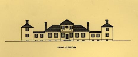
Tazewell Hall, as it was known to have appeared in the 18th century, was one of the most visually impressive private residences in Williamsburg. The length of its facade, 138.5', was rivaled only by the Governor's Palace (Moorehead 1949), and it commanded a vista-like approach south from the Powder Magazine. Situated on high ground between ravines to the east and west, the frame structure faced north toward town. The main house, one story tall, contained a two story central entrance hallway. Two story east and west wings, placed perpendicular to the main house and connected to it by enclosed passageways, gave the house an H-shaped appearance (Figure 3). It is most likely that these wings were constructed at the same time as the main house. Late 18th-century maps, such as the Frenchman's Map (1782) and the Desandrouins: Map (1781) depict the Tazewell Hall property in detail. Both maps show the structure as having wings and with the backyard enclosed.
The Desandrouins Map (1781) depicts what appears to be large formal gardens to the south of Tazewell Hall (Figure 4). Gardens
10
 Figure 3. Plan of 18th-century Tazewell Hall
11
Figure 4. Desandrouins Map showing Tazewell property
12
such as these would be appropriate for a man of John Randolph's wealth and social standing. Randolph is reputedly the author of A Treatise on Gardening by a citizen of Virginia, a how-to book on vegetable and herb gardening written between 1760 and 1770. It is likely that the experiments described in this treatise took place in the gardens behind Tazewell Hall.
Figure 3. Plan of 18th-century Tazewell Hall
11
Figure 4. Desandrouins Map showing Tazewell property
12
such as these would be appropriate for a man of John Randolph's wealth and social standing. Randolph is reputedly the author of A Treatise on Gardening by a citizen of Virginia, a how-to book on vegetable and herb gardening written between 1760 and 1770. It is likely that the experiments described in this treatise took place in the gardens behind Tazewell Hall.
In 1766 Randolph was appointed Attorney General of Virginia. It was ultimately to be an unprofitable honor, for within a few years revolutionary sentiment began brewing. Randolph, carrying out his duties, became identified with the Crown's policies and lost his popularity. Although a political moderate like his brother Peyton, he chose to continue in his post and implement the Royal Governor's increasingly unpopular edicts. By June 1775, Lord Dunmore reported that "he [Randolph] together with his Family after having suffered the grossest insults and being threatened with the loss of their lives and having their House and every thing they have destroyed, are by my advice and approbration determined to go to England knowing they could not live any longer here, with much difficulty they have been persuaded to go" (Dunmore to Dartmouth, September 24 [PRO, CO 5-1353]). With the outbreak of the Revolutionary War imminent, John Randolph fled with his family to England that September. He left behind his servants -and his home, with all of its elegant furnishings. The 1775 indenture between John Randolph and his trustees Peyton Randolph, John Blair, and John Cocke lists the opulent furnishings of Tazewell Hall on a room-by-room basis (Tazewell Papers 1775). Objects such as the "compleat set of Nanquin Tea China" in the drawing room reflect Randolph's wealth, and the prints of the King and Queen in the dining parlour are indicative of his Loyalist sympathies. The full schedule is given in Appendix 1.
In October of 1775, Peyton Randolph, acting on his brother John's behalf in order to secure debts, advertised in the Virginia Gazette for the sale of Randolph's property and belongings. The sale was delayed, however, until July of 1778, when the property was sold at auction. According to the Virginia Gazette of July 17, 1778, "the sale will be on the premises, which are to be delivered to the purchaser the 1st day of October next, for ready money" (Dixon and Hunter 1778), John Tazewell, a wealthy Williamsburg lawyer, purchased the property and immediately began renovation. Beginning on October 2, 1778, John Tazewell entered into an account with carpenter Humphrey Harwood for a wide variety of repairs and services. Harwood's account book reveals that he made repairs to steps, mended arches and "larthing", laid hearths, and whitewashed 10 rooms, 9 closets, 6 passages, and the "Sheloon" (Harwood 1778:18). All of these repairs were made before the 15th of October, when Tazewell actually came into possession of the property, and it seems almost certain that the repairs were made to Tazewell Hall.
13John Tazewell was a rich man, having perhaps the most extensive and certainly the most lucrative law practice in Virginia (Heaton 1967). Unfortunately he died only three years after having purchased Randolph's former property. In his will, recorded in James City County Court on April 9, 1781, he left his wife Sarah the use of the Tazewell Hall property (Southall Papers 1771-1850). Upon her death, the property was to pass to their son, James Tazewell. When James Tazewell died unmarried and intestate, the title passed to his two youngest surviving brothers, Littleton and William Tazewell (Southall Papers 1771-1850). Littleton Tazewell, later a representative in the state legislature, and his wife Catherine (Boush) Tazewell apparently took over Tazewell Hall, where they were to live for the next 30 years.
Insurance policies have been important documents in the reconstruction of the history of the Tazewell Hall property. The first known insurance policy on the Tazewell property was in 1802, obtained by Littleton Tazewell through the Mutual Assurance Society of Richmond (M.A.S. 1802). In this document, the house was described as "a wooden Dwelling house 150 feet long by 30 feet wide Two stories high underpined with Brick." A slightly later policy, in 1809, depicts the house more realistically as H-shaped, with a 661 main house connected to two 451 by 171 wings (M.A.S. 1809).
Towards the end of his life, Littleton Tazewell apparently suffered from prolonged periods of bad health, as referenced in a letter written in 1812 (St. George Tucker to Robert Wash, Oct. 2, 1812). An insurance policy taken early in 1815, the year of his death, indicates that Littleton was still living in Tazewell Hall, now described as a "dwelling of wood and covered with wood Body one story and wings two stories high, 136 [feet by] - 45 [feet]" (M.A.S. 1815). Like his father, Littleton Tazewell was a wealthy man, owning 242 acres, 36 lots, and 10 slaves in holdings in Williamsburg and James City County in 1815. His holdings placed him among the extensive real estate city's largest landowners, and the taxed assessment on Tazewell Hall similarly placed him in one of the most expensive homes. He owned a large quantity of household goods as illustrated by his payment of taxes on a large number of luxury items that year. His four mahogany dining tables and sideboard, 15 chairs, silver and cut glass reflect the entertainment equipage commensurate to the status of a wealthy urban dweller. Indeed, Littleton Tazewell paid over twice the taxes on these personal goods as did the average Williamsburg taxpayer, although he was not in the elite upper ten percent in the ownership of these goods. Overall, however, when Littleton Tazewell is measured against Williamsburg society in the ownership of real and personal property, he ranked in the top thirteen percent (Smart 1986). Upon his death in November, he bequeathed the Tazewell property to his wife Catherine and his daughter Sally.
14Littleton Tazewell's daughter, Sally married William O. Goode of Mecklenburg County around 1820. A letter dated January 19, 1820 states that
Sally Tazewell is to be married on Sunday next to Mr. Goode, his Father I am told having made an arrangement by which young Goode will take possession of the Tazewell property here, pay off the Debts, and establish himself as a practicioner of law in Williamsburg (Page-Saunders Papers).There is no record of the Goode's ever living on the property as the next reference to it comes in 1823, when Mutual Assurance Society Policy #5038 states that "the said building [Tazewell Hall] is at present owned by the heirs of said Littleton Tazewell residing at Mecklenburg County and is occupied by William Ball-overseer" (M.A.S. 1823). It appears that Sally Tazewell Goode and her mother had moved to her husband's home in Mecklenburg by this time. In 1830, Littleton Tazewell's heirs are still documented as owning the property and living in Mecklenburg County (M.A.S. 1830), but the name of the person who occupied Tazewell Hall at this time, recorded on the insurance plat, is now illegible. Apparently it was no longer William Ball, since his name drops out of the local personal property tax records after 1824.
In 1835, William Tazewell, acting as executor for Littleton Tazewell's estate, conveyed 400 acres of Tazewell lands to Dickie Galt. Along with the Tazewell Hall tract, this acreage included parts of the nearby Greenhow's tract, Saunder's Quarter, Saunder's undivided tract, Maupin's tract, and Lucy Quinn's lots (Southall Papers 1771-1850:Folder 182). Galt seems to have moved into Tazewell Hall, and an 1836 insurance policy describes the recent removal of one wing of the house and the detachment and subsequent relocation of the other to the east side of the property (M.A.S. 1836). The main portion of the house was also raised to form a two story structure. since this policy was obtained in January of 1836, these changes probably occurred in late 1835.
Born in 1797, Dickie Galt was the second youngest of the fifteen children of James Galt (1742-1800), silversmith keeper of the Public Gaol, and later superintendent of the Public Hospital. Dickie Galt himself became keeper of Eastern State Hospital in 1826 (Fishburne n.d.), and by 1828 personal property tax records show that he owned 7 slaves, 2 horses, and an expensive four-wheeled riding carriage. Clearly, like the Tazewells, he was a man of some means, and perhaps his purchase of the valuable Tazewell Hall tract was an indication of his upward mobility.
15Galt still owned and occupied the property in 1846 (M.A.S. 1846). Although he was married, Galt died without issue (Galt Genealogy I. E. 14, p. 11) and what happened to the property upon his death is not known. It appears that Joshua Walker came into possession of the Tazewell Hall property around the early 1850s. Not much is known about Walker, but he and his wife were involved in litigation about the Tazewell property from 1851 to 1854 (C.W.D.B. 1: 55-56). An 1853 insurance policy issued to Walker (M.A.S. 1853) identifies a new wooden addition on the east side of the house and, among other outbuildings, two wood buildings southwest of the house and one to the northwest (Figure 5). In 1849, Rear Admiral Ralph Randolph Wormeley visited Williamsburg and described Tazewell Hall like this:
Williamsburg in its mournful dilapidation affected me deeply. The residence of my great-Grandfather Sir John Randolph I found in perfect preservation as well as that of the 1st President of the Congress of the U. S. his brother Peyton... (Wormeley Family Papers 1671-1944).
In 1855, the heirs of Joshua Walker conveyed the land and structures to John B. Christian (C.W.D.B. 1: 99). John Christian, a Judge of the General Court, died later that same year. Upon his death, he left the property to his daughter Martha Christian, who later married John Mitchell.
The more recent history of the property can be more quickly summarized. John and Martha Mitchell sold the Tazewell tract to Colonel John D. Munford by 1860 (M.A.S. 1860), though the deed was not conveyed until 1863 (C.W.D.B. 2:202). Munford lived there throughout the next two decades. A former soldier wounded at Gettysburg and once Mayor of Williamsburg, he was described by a contemporary as "one of the most courtly gentlemen that ever graced, by his presence, the streets of old Williamsburg" (Colonial Williamsburg Foundation 1933:57). After his death in 1880, a cousin named Tom briefly lived on the property (Bright 1941). Bright, great grandson of Colonel Munford, used to visit Tazewell Hall as a child and remembers a garden in the rear of the, house. - He also mentions that wings were present on either side of the house. Since both wings were documented as having been removed in, 1835, Bright was possibly referring to the enclosed passageways, one of which was still standing on the east side of the house in the 1898 photograph (Frontispiece).
In 1880, the land was conveyed to Mary E. Hamlin (C.W.D.B. 3:500-502). In 1901, Mary Hamlin conveyed 305 acres containing the Tazewell Hall property to Mr. and Mrs. Andrew J. Barnes (C.W.D.B. 5:706-708). The property was in the Barnes family in 1906, when the Colonial Extension Company, Incorporated, bought the property for $12,000 in order to extend South England Street (C.W.D.B. 10:276-277). At this time the
16
Figure 5. 1853 Mutual Assurance Society policy.
17
Tazewell tract was divided into smaller lots, many of which were soon sold and developed with homes along South England Street and Newport Avenue. In 1908, William Gray purchased 28 acres of land on the west side of England Street, and around that time the house was moved from its original location in order to extend the street. This relocation placed the house about 12 feet to the west, facing east towards England Street.
In a deed dated October 18, 1910, William Gray conveyed the land containing Tazewell Hall to Susan Garrett Nelson (C.W.D.B. 6:34-35). She owned the property, where she lived with her husband, Peyton Randolph Nelson, until she sold it to Reverend W. A. R. Goodwin in 1927. Susan and Peyton Randolph Nelson were still allowed to occupy the house under the Restoration's life tenancy policy. Peyton Randolph Nelson, a descendant of both Peyton Randolph and General Thomas Nelson of Yorktown, was quite a colorful character. He is reputed to have imported carloads of wild horses into the then-sleepy town of Williamsburg and to have placed brassieres on his cows because someone had been stealing their milk (Rouse 1982). After the death of his wife, he continued to live, rather eccentrically, at Tazewell Hall into the 1940s.
In the meantime the restoration of Williamsburg was proceeding. In 1929, Reverend Goodwin and his wife sold the property to the Williamsburg Holding corporation (C.W.D.B. 13:486-87). In a series of legal maneuvers, the Williamsburg Restoration, Inc. then conveyed the property to John D. Rockefeller, Jr., who conveyed the land back to Williamsburg Restoration, Inc. in 1939, subject to life tenure for the current occupant.
In 1954, with the expansion of the Williamsburg Lodge, Tazewell. Hall was purchased by Lewis A. McMurran, Jr. and dismantled, piece by piece. The old property was graded and an asphalt parking lot and landscaped lawn replaced the former house site. The house lay in storage until 1964, when the McMurrans began reconstructing Tazewell Hall to its 18th-century appearance. Tazewell Hall now stands overlooking the James River in Newport News, Virginia.
CHAPTER 3
PREVIOUS ARCHAEOLOGY
Since the restoration of Colonial Williamsburg began in 1926, sporadic archaeological investigations have occurred on the Tazewell Hall property. The first archaeological report on the site was the description of a utility trench cut alongside South England Street on February 23, 1934. H.R. Shurtleff head of Colonial Williamsburg's Department of Research and Record, noted "two parallel foundation walls running east-west, 26'10" apart from each other"(Shurtleff 1934:1). He stated that "the bricks were large, looked old, and had a LIME shell mortar. The wall was one stretcher and two headers thick." This was a portion of the colonial foundation of Tazewell Hall.
No further archaeology was done on this property until 1948. In October and November of that year, James M. Knight of Colonial Williamsburg's Architecture Department, with a crew of two, completed fairly extensive testing on both sides of South England Street (Block 42, Archaeological Area A & Block 44, Archaeological Area B). Area A, on the east side of South England Street, measured 100 feet north-south by 75 feet east-west. Area B, on the west side of the street, was about 75 feet square.
These excavations, typical of archaeological investigations conducted in Colonial Williamsburg prior to 1957, had one main purpose: the discovery and investigation of the brick foundations present on the property. Although in most cases, archaeological excavations led to the reconstruction of colonial buildings, in this instance no reconstruction was attempted, perhaps due to South England Street cutting the property in half. Some artifacts were collected in the 1948 excavations but they were not systematically recorded or analyzed.
The method employed to locate these brick foundations involved diagonal cross-trenching, oriented roughly northwest-southeast. These trenches, dug a shovel blade in width and spaced about 5' apart, were usually excavated to subsoil. When brick foundations were encountered, cross-trenching was temporarily abandoned and the foundations traced and exposed. This involved the removal of one or two feet of earth on either side of the foundation, a method which usually destroyed all or most of the original builder's trenches. These foundations were then inspected, mapped, and photographed.
Unlike much of Mr. Knight's work in Williamsburg, no summary description of archaeological features was prepared for the 20 Tazewell Hall property. Mention of this work, however, was made by Singleton P. Moorehead of the Architecture Department in his 1949 report on the architecture of Tazewell Hall. In this report he stated:
The foundations excavated show the original structure except where digging was impossible in South England Street. Fortunately pretty complete evidence of the original wings, covered-ways and part of the main portion was uncovered which, as mentioned above, proved the accuracy of the 1809 insurance policy. Since the main portion of the building exists a complete picture of the whole layout was therefore possible.
The excavated foundations indicated chimney locations in the two-story wings, the fact that a full basement existed under all the original structure except the east wing, and the size of the front porch. The locations of several minor outbuildings were also determined, including an ice house.
(Moorehead 1949:16)
This report goes on to describe in detail the architectural features of Tazewell Hall, mostly as revealed by documentary research. It is particularly interesting that no other documentation of the 1948 excavations mentions an ice house nor was one located during the 1984 project. James Knight, who provided many valuable recollections during the 1984 project, could not recall ever finding an ice house.
Despite the lack of a written report by Mr. Knight, maps and photographs of the excavation do exist. The map of archaeological features, prepared by Knight, shows four foundations: the colonial house, two dairies, two smokehouses, and a kitchen/laundry (Figure 6).
The colonial house was discovered on both sides of South England Street. Photographs show that the foundation was extensively cleared, with only the portion under South England street remaining undisturbed. It is not known what amount and type of damage was the house foundation when South England Street was constructed. It originally, measured 27' N/S by 65' E/W in size, with indications of two identical 17' E/W by N/S wings connected to either side of the main portion of the house by 19' long "covered ways," or enclosed passageways.
The part of the main house found in Area 44-B was about 35' E/W and 27' N/S, with two interior hearth bases uncovered along the west wall (Figure 7). An interior partition and a 19th-century bulkhead entrance to the main house cellar were also found. The foundation was 12 courses high, 16 ¾" thick, and set in English bond with shell mortar. Brick size was noted as 8 ¼" x 4" x 2 ¼" to 2 ½".
21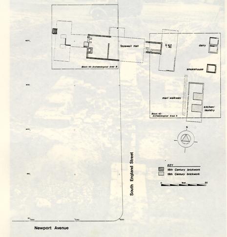 Figure 6. Features uncovered by James Knight, Oct-Nov 1948
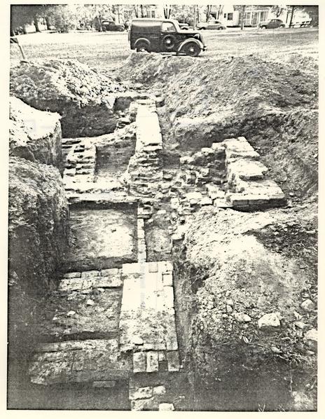 Figure 7. West foundation wall of main house
The west wing of the house, moved in 1835, was also investigated. The foundation walls were removed at the time the wing was moved, but the archaeological map shows a small section of brickwork remaining in the connecting covered way. The bulkhead entrance to the west wing cellar, also still intact, was cleared and recorded. Based on a comparison of brick sizes, Knight assigns the construction of the wing to the same period as the main portion of the house. Photographs show fairly extensive digging in this area (Figure 8). An L-shaped interior partition (?) and two hypothesized interior chimney bases were also noted on the map.
The three recorded outbuildings all fall on the east side of South England Street in Area 42-A. Although this is beyond the 1984 project area, these features will be briefly described.
The "dairy" was composed of two overlapping 10' by 10' brick foundations (Figure 9). The earliest, probably dating to the 18th century, is described as being of English bond with shell mortar, with 8 ¼" x 4" x 2 ½" bricks. Either this or the later foundation, which Knight stated was of 19th century construction, is probably the feature labeled as a dairy on the 1809 insurance map (M.A.S. 1809). Photographs show that both of these foundations were cleared, probably destroying the builder's trenches, but that interior fill was probably not excavated.
The "smokehouse" was located twelve feet south of the later of the two dairy foundations. It was composed of two 101 square foundations, one directly over the other. The earlier brick foundation, set in English bond with shell mortar, contained bricks measuring 8 ¼" x 4" x 2 ½". This or the later 19th-century building was labeled as a smokehouse on the 1809 insurance plat. The entire foundation was exposed, but interior fill appears to have been left intact.
The "kitchen/laundry" was a 17' E/W by 45' N/S foundation lying 11' south of the smokehouse (Figure 10). This is where one wing of the house was probably relocated when it was moved in 1835. The 1948 archaeological map describes the brickwork as 19th century, probably meaning that it was set with sand mortar. Two panels of brick paving, 2' by 6' in size, were found on part of the interior floor. The southern 4' of the feature was not excavated, however, and most of the interior fill probably remained intact. Part of a marl walkway, running north-south, was found on the western side of the foundation.
The Knight excavation in 1948 was the last archaeological investigation of the property before the 1980s. Until 1984 none of the project area outside of Knight's Archaeological Area 44-B had ever been archaeological logically examined. Despite the lack of archaeological work (outside of Area 44-B), various activities on the site during the 20th century have undoubtedly caused some
24
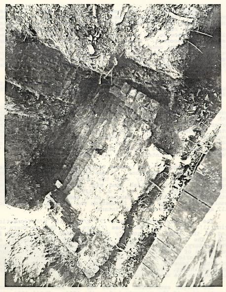 Figure 8. Bulkhead entrance to west wing cellar
25
Figure 8. Bulkhead entrance to west wing cellar
25
 Figure 9. Foundation of dairy
26
Figure 9. Foundation of dairy
26
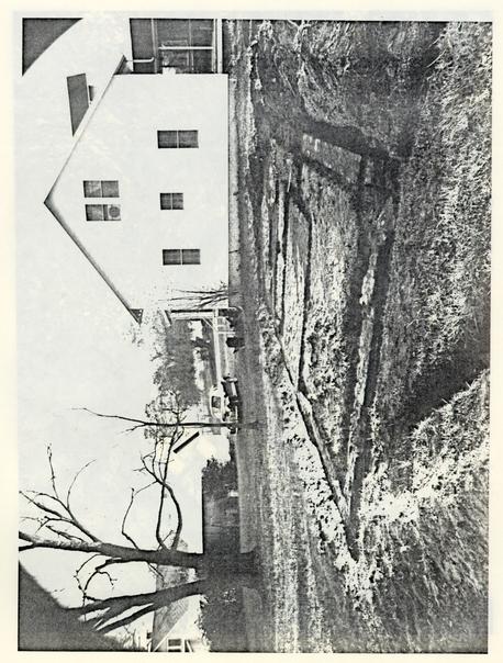 Figure 10. Foundation of laundry/kitchen
27
disturbance to the western side of the street. These would include the construction, property development and subsequent dismantling in 1954 of the 20th-century Tazewell Hall. In addition, the machine grading for the construction of the Williamsburg Lodge parking lot, as subsequently proven during excavation, erased virtually all traces of soil layers and features.
Figure 10. Foundation of laundry/kitchen
27
disturbance to the western side of the street. These would include the construction, property development and subsequent dismantling in 1954 of the 20th-century Tazewell Hall. In addition, the machine grading for the construction of the Williamsburg Lodge parking lot, as subsequently proven during excavation, erased virtually all traces of soil layers and features.
CHAPTER 4
FIELD AND LABORATORY METHODS
Field Methods
Contemplation of the salvage excavation of the Tazewell Hall site presented some major logistical problems. Since the area involved was so large for a five-month excavation, it was clear that cultural features had to be selectively excavated according to their importance in light of the project's research objectives. It was also known that the grading for the parking lot and the excavations conducted by James M. Knight in 1948 had resulted in major stratigraphic disturbances, particularly in the vicinity of structural features.
Documentary information regarding the property, along with Knight's archaeological drawings and photographs, suggested the probable location of the most important features on the site. Features in the project area were located both under the lawn behind the Williamsburg Lodge and under the adjacent blacktop parking area.
Excavation of the site took place between June 25 and November 12, 1984. From late June to mid-July the crew excavated test units in the lawn south of the Williamsburg Lodge East wing. Excavations beneath the adjacent parking lot took place between late July and mid-November.
Because the lawn obscured all cultural features on the north side of the impacted area, the initial 2.5' by 2.5' test units were placed randomly. Thirteen of these units were begun, and as features were uncovered six of these units were expanded in 2.5 foot increments to more fully expose the extent of these features. The result was a series of trenches and pits (Figure 11). All layers and features were excavated by "context" (for an explanation of context, see below).
The blacktop parking area south of the lawn presented a different problem. The asphalt surface was underlain by a 0.7'-1.0' layer of compacted orange sand. Both this sand and the asphalt were removed mechanically in order to expose the underlying layers of soil.
In order to ease the crowded parking situation at the Lodge during a peak time of visitation, the asphalt of the parking lot was removed only in stages. On July 12 the northeast bay of the parking area was stripped using a Drott "Grade-All" tractor. The
30
 Figure 11. Location of units in north yard
31
southeast bay, which was still used for parking while the northeast bay was being archaeologically investigated, was stripped on August 27. The final two central bays were stripped between November 6 and November 8, allowing only six days of excavation on this part of the property. On November 12 the Universal Construction Company of Decataur, Georgia began mechanically excavating the entire area to begin construction of the Lodge Addition. Further archaeology was impossible, and the stripping and mechanical excavation of the western parking bays could only be archaeologically monitored.
Figure 11. Location of units in north yard
31
southeast bay, which was still used for parking while the northeast bay was being archaeologically investigated, was stripped on August 27. The final two central bays were stripped between November 6 and November 8, allowing only six days of excavation on this part of the property. On November 12 the Universal Construction Company of Decataur, Georgia began mechanically excavating the entire area to begin construction of the Lodge Addition. Further archaeology was impossible, and the stripping and mechanical excavation of the western parking bays could only be archaeologically monitored.
The stripping of these areas revealed that all site-wide cultural layers had been removed by machine grading when the parking lot was constructed, save for a small area of disturbed plowzone near the center of the site. This absence of stratified layers effectively precluded comparison of this site with the stratified yard layers excavated behind the Peyton Randolph House. While this was disappointing, it permitted more complete excavation of all those features cutting into subsoil, such as the west wing cellar and the various garden features.
Following the current recording system used by the Office of Archaeological Excavation, features and layers were excavated by "context." This system facilitates stratigraphic interpretation using the "Harris-Winchester Matrix System" (Harris 1979). Each context consists of a unique layer or feature located within a single 10 by 10 foot unit; the same layer or feature spanning more than one 10 by 10 foot unit was given a separate context number in each. Standard information. on soil conditions, inclusions, and stratigraphic position was recorded on context record forms, an example of which is given in Appendix 3. Meaningful groups of contexts were later combined into "features" and "master contexts" Appendix 4).
The initial step in such a recording system was the establishment of a grid of 10' by 10' units over the site. This grid was established from an arbitrary datum point, across Newport Avenue off the southwestern corner of the impacted area. This point was designated ON OE. Each 10' by 10' unit was then designated by the location of its northwestern corner, north and east of this datum point. For convenience in mapping, a length of steel rebar was driven into the ground and set in concrete at point 300N 150E, about ten feet south of the East Wing of the Lodge. Unit corners and elevations were then established relative to this point. Within some 10' by 10' units, it was necessary to have more precise control of artifact location. These units were divided into smaller 2.5' by 2.5' subunits. These sub-units were designated using letters, which were affixed to the context number of the 10' by 10' unit being excavated (e.g., 44B-216N).
32Each surface layer or feature within each 10' by 10' unit was mapped. Cross-trenches and backfilled areas from the Knight excavations in the 1948 were encountered throughout the area, in the vicinity of the main portion of the colonial house and the west wing cellar. A basic principle of archaeological excavation is that the layers and features on a site should be removed in the reverse order in which they were deposited, in order to prevent later features from contaminating the artifact assemblages of earlier ones. Since these trenches and pits were among the last features to be created on the site, they were among the first to be removed. In most cases these "Knight fills" were removed with pick and shovel, after it was determined that they were stratigraphically meaningless. None of this material was screened, although artifacts were collected when encountered.
Following the removal of the Knight fills and other modern disturbances such as the fill of utility, trenches, features were excavated within each area in the reverse order of their deposition. In most cases features were sectioned, and one half of the feature was removed first. A profile was then drawn before the second half was excavated. In only a few cases was material screened, but all excavated earth was carefully inspected before being broadcast. The few deposits to be screened were passed, dry, through ¼ inch wire mesh.
The western one-third of the project area, which could not be archaeologically investigated, was mechanically excavated by U.C.C. in mid-November. Monitoring and visual inspection of the sidewalls of the cut indicated that most of the upper part of this deposit was orange clay ravine fill. Small non-structural features may have been present, but it is unlikely that brick foundations were located in this area. The only foundation uncovered was a brick well, found on November 16. This well, apparently capped in 1954 during house dismantling, was not closely investigated since it was associated with the 1908/1909 position of the house, and hence must have been dug after this date. Inspection of the construction of the well lining, made with sand mortar and machine-made bricks, confirmed its relatively late construction.
Laboratory Methods
The processing, cataloguing, and analysis of artifacts from the Tazewell Hall excavation began in July of 1984. A 10' x 50' mobile office trailer was established as a field laboratory near the site. This provided adequate storage and work facilities, and contributed to the ease of processing.
The recovered artifacts were delivered to the laboratory, where each group was accessioned by context, date excavated and number of bags per unit. Each group of artifacts was then sorted according to a system established by the Office of Archaeological Excavation to assign priorities of treatment procedures. These three levels of treatment were based on the archaeological context of a given unit and were established by the staff archaeologist at the time of excavation.
Generally, those groups of artifacts from disturbed contexts were assigned Level I designations, and only the basic steps of processing and coding were carried out. Those units from more sound archaeological contexts were assigned Level II designations which provided for more complete analysis at a later time. Level III groups were those which were thought to have the greatest potential for the interpretative analysis of the site. Certain Level II groups are upgraded to Level III analysis as excavation progressed and more was known about the site.
At this time the artifacts were closely examined for extremely fragile items that should be removed for conservation or other immediate attention. These include faunal and floral remains, metals, paper, cloth, or other structurally degraded artifacts. Only Level II and III faunal material was analyzed from the Tazewell Hall-project.
All artifacts that were not thus removed were then washed, and each group assigned a terminus post quem date. This date is established by identifying the artifact in a group for which the most recent documented date of production can be assigned, and is an indicator of the earliest date that a specific layer or feature could have been deposited. After the TPQ date was assigned to a specific context, this information was forwarded to the staff archaeologist for use in making field decisions.
A note of warning should be that these TPQ dates are the best possible estimate available at the current research stage, and refinements and additional dates will no doubt be added. This provides a working temporal scheme for the archaeologist as an aid in ongoing field research; more specific artifact research is generally carried out in later stages of analysis on an as-needed basis.
34The artifacts in each group were then numbered according to context and coded for computer analysis. The coding system developed by Colonial Williamsburg translates descriptive information into a numerical code for machine readability. Each artifact's type, decorative attributes, marks, or other distinct features are recorded on a coding sheet for each context.
After the unit was coded it was again separated according to artifact type. All ceramics were removed in preparation for crossmending. Glass, pipestems, identifiable metals, and other diagnostic artifacts were retained with the unit; all others were removed in preparation for alternate storage.
Processing and coding of the Tazewell Hall artifact assemblage was completed in November of 1984. At this time it was decided that only selected units would be crossmended to provide information of temporal relationships between various features of the site.
Crossmending is one of the most important processes of artifactual analysis. It is an attempt to match all sherds of a given ceramic type to reconstruct individual vessels, and thus demonstrate relationships between various excavation contexts. Before crossmending of ceramics and glass each individual sherd was assigned a unique sherd number. This number was an arbitrary assignment beginning with 001 for each provenience unit, and printed in red ink. This unique sherd number provides An additional control and element of precision in crossmending procedures.
Through this process a series of unique vessels were identified and given unique vessel numbers. Wine bottle glass was similarly crossmended and a minimum vessel count was constructed using bottle bases.. Table glass and architectural stone were also crossmended. A list of these unique vessels, their descriptions and proveniences can be found in Appendix 5.
An inventory of the artifacts from the Tazewell Hall excavation, as well as the artifact groups, are housed in the storage facilities at the Office of Archaeological Excavation, Colonial Williamsburg Foundation. Certain artifacts were deemed important on the basis of their unique characteristics or their potential for study, either within the assemblage or in comparison to similar archaeological examinations. These artifacts form a study collection catalogued in storage drawers or cabinets in the Office of Archaeological Excavation.
CHAPTER 5
ARCHAEOLOGICAL RESULTS
A. Main House/West Wing
Excavation near the colonial house foundation was concentrated around the main house west wall and in the west wing cellar and enclosed passageway. There were two purposes for these excavations: (1) the identification of architectural features, as revealed by characteristics of the foundation or architectural associated artifacts, and (2) sampling of the artifacts deposited into the west wing cellar when it was filled in 1835. This tightly-dated filling episode furnished a secure baseline with which to analyze these late 18th and early 19th century artifacts.
As described in Chapter 3, James Knight conducted fairly extensive excavations around the main house and the west wing in 1948. A number of cross-trenches passed through this area, and all brick foundations that were encountered through the trenching were exposed by Knight and his workers. The areas around the west wall of the colonial house and the bulkhead entrance to the west wing cellar had been entirely excavated, and, in all, at least half of the fill of the west wing cellar had already been removed and backfilled. Nevertheless, enough unexcavated areas remained to obtain a fairly clear picture of stratigraphic relationships and artifactual context.
Architectural Features Colonial House
The architecture of Tazewell Hall is fairly well known from documentary evidence and photographs of the house as it appeared during the period 1909-1954. Singleton P. Moorehead's architectural report (1949) attempted to reconstruct its 18th-century appearance from the then-existing structure, as well as from historical and archaeological data. The information gathered in the 1984 excavation is useful mainly as physical corroboration of Moorrehead's reconstruction, but a few unusual construction details did arise in the course of the project.
Although James Knight's 1948 excavation had tested extensively in the main portion of the house and its west wing, it was felt that additional information could be gathered concerning structural changes to the house. More specifically, the 1984 excavations of the house were to focus on areas which 36 could refine dating information, such as time of construction, and various architectural details concerning the west wing.
The parking lot surface and base were first mechanically stripped to reveal areas of the 1948 excavation backfill. Two test units were placed inside the main house foundation in order to remove the 1948 backfill (context numbers 44B-94, -95, -102, -104, -105, -106, and -109). This was done primarily to orient the current work with the Knight excavation and to locate foundation walls in order to determine whether the 1948 excavations had left intact any of the original builder's trenches. These builder's trenches could potentially contain important clues for dating the construction of the house through the inclusion of datable artifacts.
The west wall of the colonial house foundation, uncovered by Knight in 1948, was re-exposed. As Knight noted, the wall was 1.4' thick and set in English bond with shell mortar. Most of a 1.0' wide builder's trench was still present along the outside of this west wall. Unfortunately, however, this builder's trench (44B-110 and 44B-117) yielded no datable artifacts with which to provide a firmer date for the construction of the house.
The two interior chimney bases along the west wall, previously excavated by Knight, were relocated. The southern one, 6.65' by 4.3' in size, was undoubtedly part of the original house. Moorehead depicted this on his reconstructed plan as a centrally-located chimney along the west wall of the southwestern room (Moorehead 1949:15). The northern chimney base, however, was a 19th-century feature, almost certainly built in 1835 after the west wing had been removed. Measuring some 5' by 3', it was slightly smaller than the other chimney base and became a corner fireplace in the northwest room of the remodeled house (formerly the passage to the western covered-way). This feature was uncovered at some 2' below Knight's recorded elevation for the top of the original foundation wall, indicating that some 2' of fill was graded away in this area in connection with the construction of the parking lot.
A bulkhead entrance into the main house cellar, extending from the foundation wall between these two chimney bases, was also undoubtedly built in 1835. A new entrance into the basement was needed at that time, since the previous bulkhead had been located in the demolished west wing. It was about 4' wide, composed of six to eight steps, and seemed to incorporate part of the original foundation wall of the enclosed passageway.
Excavation was halted after removing the Knight backfill and examining these features, and for that reason the cellar floor inside the colonial house was not uncovered. Fill inside the cellar under the main portion of the house was not excavated, since it was certainly dumped there in 1908 or 1909 and would 37 reveal no information about the 18th- and 19th-century history of the property. Although removal of the 1908/09 fill may have revealed certain architectural details of the cellar, the time limitations of the project necessitated the retrieval of other types of information.
Cellar Fill and Architectural Features West wing
Knight's 1948 investigation resulted in a map of the brickwork uncovered, including details of the west wing and its interior hearth bases. However, after the parking lot had been stripped and the area cleaned, it was evident that Knight had not completely excavated the west wing cellar. This supported Knight's statement that he had only tested that area of the site (Foster 1984a). It was expected that the material assemblage from the undisturbed cellar fill would uphold the 1835 dating for the removal of the wing, as described on the 1836 insurance policy (M.A.S. 1836), as well as furnishing undiscovered information about the construction and use of the cellar.
It was imperative that the 1948 backfill first be removed from the cellar area so- as not to contaminate the original backfill of the wing. This 1948 backfill, although easy to trace in some areas, was difficult to distinguish in others. Once cleared of Knight backfill, the stratified cellar fill was excavated, and the architectural features of the west wing and connecting covered-way extensively studied. These included: the bulkhead entrance into the west wing cellar, the brick foundation wall, an unusual trench in the subsoil below the cellar floor, an L-shaped brick feature on the floor, and a lightning rod located immediately outside the south wall of the connecting covered-way.
Cellar Fill
Although the fill in the west wing cellar was almost certainly all deposited simultaneously in 1835, it was fairly well-stratified. Various layers of fill were easily discernible and the filling history of the cellar could be reconstructed (Figures 12 and 13).
The initial step of the filling, after the two story wooden wing structure had been removed, was the removal of the brick foundation. The bricks were salvaged, possibly for use as part of the foundation of the new kitchen/laundry on the east side of the property. Bricks broken during this process probably formed part of the second and fourth layers of fill.
38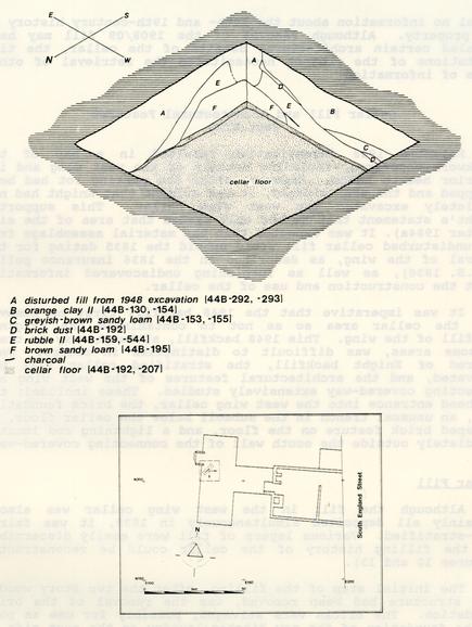 Figure 12. Isometric profile of west wing cellar fill
 Figure 13. Profile of west passageway
When most of the foundation had been removed, the filling began. The first layer (44B-153, -155, and -302) comprised of brown sandy loam, was dumped in the west part of the cellar. This fill was fairly clean, but included small amounts of brick, mortar, marl, and charcoal. A 0.05'-0.08' thick charcoal lens (44B-317) was found atop this clean fill near the center of the cellar.
The subsequent layer (44B-193 and 44B-194) was marked by a 0.8-1.3' thick layer of rubble. This layer was composed almost totally of brickbats and contained relatively little other destruction debris, such as window glass and nails. It was dumped into the connecting passageway from the eastern side, near the main house.
The third layer (44B-162, -163, -301, and -321) was composed of a compact yellowish brown sandy clay loam (probably redeposited subsoil) used to cap the fill on the east side of the wing. This clay was also spread in a 0.2-1.3' thick layer on the west side of the lower rubble mound and sloped down to the cellar floor in the southern portion of the wing.
After this filling sequence, the cellar hole was still only partially-filled. Another 0.3-1.7' thick layer of brick rubble (44B124, -126, -159, -303, and -544) was added. This layer contained brickbats, chunks of shell mortar, and large quantities of destruction debris such as window glass, nails and .architectural hardware. It is thought that this material was taken from the framing, foundation walls and hearths of the west wing and passageway itself as they were removed. This layer also included most of the architectural stone found during the excavation.
Finally, a compact yellowish brown sandy clay (44B-118, -119, -120, -121, -130, -154, and -300) was placed over the fill on the west side of the wing. This 0.3-1.8' clay cap resembled the third tip of fill and probably came from the same source.
Crossmends between the various fill layers indicate that the entire cellar was filled at the same time. Fragments of 45 unique vessels were contained within two or more of the various fill layers, suggesting some degree of mixing when the fill was deposited. Clearly, however, at least three sources of fill were used: brown sandy loam, perhaps topsoil and debris from cleaning the yard; rubble from the destruction of parts of the west wing; and orange clay subsoil, perhaps taken from the nearby ravine.
It is believed that the rubble fill contained primary refuse associated with the removal of the wing. This conclusion is supported by the relatively large number of vessels that: (a) were reconstructable, and (b) consisted of a large number of mendable fragments. The artifact assemblages of the other tips 41 of fill were composed of small fragments of ceramics and glass. Vessels were represented by only one or two sherds, suggesting that these fills were secondary in nature and perhaps generated from yard clean-up.
Floor Level
Sealing the clay subsoil at the bottom of the cellar was a compact layer of dark brown sandy loam, ranging in thickness from 0.25' to 0.41'. Containing coal, oyster shell, brick fragments, charcoal, and shell mortar, this layer was initially interpreted as a deposit related to cultural activity occurring within the cellar. If indeed this was a floor accumulation, the location of de facto refuse (South 1977:297; Schiffer 1972) within this layer would be relevant to cellar related activities.
Pressed into the top of the dark brown sandy loam was a thin lens of brick dust and fragmentary brick debris. The lens was present only in those areas of the cellar adjacent to where foundation walls had been removed. This brick dust appears to be the remnants of wall destruction activity and would uphold the hypothesis that the underlying dark brown sandy loam represented a floor residue level present when the west wing was removed. It is believed that after the wing structure had been removed from its foundations, workmen standing in the open cellar hole removed the brick foundation walls in order to reuse the brick elsewhere. Dust and debris generated during these destruction activities would have been scattered in the area that they were working, and pressed into the floor level. It is interesting also to note that the dark brown sandy loam layer was absent only in the areas where the foundation walls had been formerly located, thus providing further evidence that this layer was deposited prior to the destruction of the foundation walls.
The dark brown sandy loam layer also contained large quantities of coal at the southern end of the cellar. From Randolph's schedule of 1775 (Appendix 1), it is known that coal was being used to heat at least some of the rooms at Tazewell Hall, and this coal may have been stored in the cellar.
Analysis of the Floor Deposit
In an attempt to determine whether the dark brown sandy loam actually represented a gradual accumulation of debris on a floor level rather than simply a layer of fill, the following research questions were posed.
- 1.Were there crossmends between the "floor" level and the other layers of cellar fill?
42 The presence of crossmends between separate deposits, such as between the floor and the remainder of the cellar fill levels would establish the contemporaneity of the deposits (South 1977:291). This would indicate that the dark brown loam was deposited during the filling episode in 1835. An absence of crossmends, indicating two separate episodes, would be expected if the dark brown sandy loam represented a floor which had been deposited prior to the removal of the wing. - 2.What was the relative size of the artifacts, particularly easily broken items such as ceramic and glass, from the floor level as compared to the other layers of cellar fill?
Artifacts have been demonstrated to display distinct size differences in accordance with the type of deposit to which they can be associated (Schiffer 1983:679). Casual refuse (Wise 1976:269), such as yard scatter or floor build-up, is generally trampled and therefore broken into smaller pieces than refuse which has been deposited into a defined space or feature, such as a trash pit. If this layer represented a floor build-up, the artifacts should be significantly smaller than those of the cellar fill layers, particularly the primary refuse associated with the destruction of the foundation. In addition, casual deposits are normally characterized by small percentages of mendable fragments and reconstructable vessels within the ceramic and glass assemblage when compared with primary trash deposits (Wise 1976:269). - 3.
Did the distributions of artifacts within this layer indicate specific activity areas within the cellar?
Studies have shown that spatial analysis of both sheet refuse and artifacts distributed on living surfaces can reveal information about yard use and pinpoint activity areas (Moir 1982; Derry, Edwards, and Brown 1982). It was hoped to determine the presence of certain activity areas within the cellar, such as specialized storage areas or possible working activity zones, through the use of spatial analysis of artifacts from the "floor" level.
In order to test these questions, the following types of analyses were performed and results are given below.
1. Ceramic and glass assemblages from the layers of cellar fill were checked for crossmends with the same assemblages from the hypothesized floor. This resulted in 6 actual crossmended ceramic fragments, with another 16 ceramic and 3 glass vessels represented by noncontiguous fragments. Noncontiguous fragments of a unique vessel are associated because the sherds appear, through examination of body type, vessel form, and decoration, to be from the same vessel. Absolute certainty is not possible, 43 however, due to the lack of a glue fit (see Appendix 4 for a more thorough explanation of noncontiguous fragments). A few of the crossmends occurred between the "floor" and the uppermost tips of cellar fill, tending to preclude chances of errors in stratigraphic interpretation. It is likely, however, that these crossmends were the result of artifacts, associated with the fill, being mixed and pressed into the upper portion of the floor when the fill was deposited. A much larger number of unique vessels (24) crossmended between two or more layers of cellar fill, suggesting a much higher degree of mixing between these layers than between the fill and the "floor".
2. Ceramic and glass sherd size was also analyzed as an indicator of the type of deposit represented by the dark brown sandy loam (see Appendix 6). Studies of the effects of trampling on archaeological deposits (McPherron 1967; Kirkby and Kirkby 1976) have concluded that, along with other materials, artifacts tend to be reduced in size on the floor of an activity area. The more intense or long-lasting the activity, the greater the reduction in mean size. This principle can be extended to analyze the nature of a hypothesized floor deposit, since the mean sherd size of this deposit should be smaller than that of a comparable "untrampled" deposit.
In this case two deposits were compared: the dark brown cellar "floor" and the rubble layers of cellar fill deposited in 1835. The rubble layers of fill contained primary refuse associated with the removal of the west.wing, while the remainder of the fill presumably represented secondary refuse from an unknown area. By using only the rubble layers, it was felt that an untrampled primary deposit could be obtained for a control sample.
The longest axis of each sherd was used for calculation of size. The sherds were measured using ¼" intervals, ranging from 0-0.25" to 6.25-6.50". A total of 172 ceramic and 438 glass sherds were measured from the "floor" layer, while 151 ceramic and 321 glass sherds were measured from the rubble fill. Student's T test (Chao 1974:202-204; Thomas 1976:227-260) was used to evaluate the significance of the differences between sorts of means. Results of these tests follow:
Ceramics:
Three groups were established for sherds from both the floor and the rubble fill. Group 1 was composed of the thinnest-bodied, most easily broken wares: porcelain, bone china, and porcelaneous wares. Seventeen sherds in this category were found on the floor (mean=1.2426, standard deviation [s]=0.5313), while 20 were located in the fill (mean=1.1875, s=0.7689). There was no significant difference in size between the fill or the floor artifacts (T= -0.2490). Group 2 was composed of slightly 44 thicker-bodied wares: delft, white saltglazed stoneware, yellow ware, creamware, pearlware, and whiteware. The majority of the ceramics from both floor and fill layers fell into this category (floor: n=148, mean=1.4544, s=0.6919; fill: n=79, mean=1.6883, s=1.1959). The fill sherds were significantly larger at the 0.005 level (T=1.8668). Group 3 was composed of the thickest-bodied wares: redwares, Colono-Indian ware, American blue and gray stoneware, Albany slip stoneware, Staffordshire brown stoneware, Fulham-type stoneware, and slipware. Only seven sherds in this category were found on the floor (mean=2.1607, s=1.9548), while 52 were found in the fill (mean=2.8894, s=1.4823). No significant size difference was discovered (T=1.1762).
Glass
The only glass fragments measured were those that could be identified as bottle glass. Some 321 fragments were found in the rubble fill (mean=1.8111, s=0.9907), while 438 were found on the floor (mean=1.3590, s=0.6912). The fill fragments were significantly larger even at the 0.001 level of significance (T=7.4039).
This data is not as clear-cut as might be hoped, but it appears that a case can be made for some trampling on the "floor" level. Particularly interesting is the relative absence of Group 3 ceramic sherds and of large wine bottle bases in the floor deposit. The Group 3 sherds, which are more likely to break into larger pieces, may have been swept up from this deposit when they were broken. Since only four wine bottle bases were found pressed into the floor (as opposed to 12 from the rubble fill), a similar selective process may have been at work here. The removal of large debris is a common method of keeping activity areas clean (Schiffer 1983:670). This biasing factor probably did not effect the Group 1 and 2 ceramics to any great extent, since very large pieces of these ceramics are somewhat rare. It may have had a greater effect on the glass data, but even if the 12 bottle bases are removed from the calculation, the result is highly significant (T=6.7726).
Bone
Corroboration of this "sweeping-up" effect can be gained from analysis of the faunal material from the cellar (see also Appendix 8). The fill contained a variety of large bone fragments from cattle, swine, and horses (including a complete radio-ulna from a horse, measuring 35.8 cm [14"] in length). The "floor" layer contained only eight bones: 4 pig, teeth, 1 cow tooth, 1 cow phalange, 1 sheep or goat mandible fragment, and 1 muskrat pelvis fragment. None of these bones measured greater than 5 cm [2"] in length. Any larger bone fragments dropped on the floor are likely to have been picked up, as was probably the case with the larger ceramics and glass.
453. In order to perform spatial analysis, the 101 units containing the loam "floor" level were subdivided into 2.5' horizontal squares. These 2.5' units were assigned letter designations and artifacts from each unit bagged separately. Piece plotting of the exact location of each artifact was considered briefly, but due to the time constraints of this project, it was deemed that the 2.5' unit detail of analysis would be adequate for determining spatial information. Use of the 2.5' units would also be comparable to methods used during the Peyton Randolph Outbuildings Project, allowing some degree of intersite comparison (Derry, Edwards and Brown 1982; Derry and Edwards 1984). Modern disturbances and the prior archaeological excavations on the property had destroyed some areas of the cellar fill and floor, and consequently only approximately 50% of the cellar floor remained to be excavated. Figure 14 shows the 1984 limits of excavation imposed over a plan of the west wing.
Four artifact categories (ceramics, wine bottle glass, nails, and window glass) were examined in this analysis. It was believed that distributions of artifacts could potentially reveal information about spatial organization within the cellar (Moir 1982; South 1977; Schiffer 1972). For example, high concentrations of wine bottle glass could indicate where wine and other spirits were stored. Figures 15 through 17 show the results of this analysis using SASGRAPH. These results will be discussed below.
In Figure 15, showing the distribution of the total number of artifacts considered, it can be seen that the areas where the cellar walls had formerly stood (lower right-hand corner) were marked, not surprisingly, by a total absence of artifacts of any type. This figure also shows clusterings of artifacts along the passageway area, in the upper right-hand area of the figure.
The wine bottle glass did not show any distinct clustering on the floor surface and no conclusions could be drawn about the storage of liquors. The ceramics, however, were clustered in the passageway area (44B-216C,D, H and 44B-217 D, H, L, M, and R). These ceramics comprised 35 unique vessels, discounting the accidental breakage of one or two vessels accounting for a clustering of sherds in that area. Table 1 below lists each unique vessel found in the 2.5' units noted.
It is obvious that some form of activity relating to ceramics took place in this area. All but one vessel represented from the cellar floor (a Colono-Indian ware bowl) were fine tableware forms, such as Chinese export porcelain teawares, pearlware shell edge plates and platters and pearlware serving dishes and teawares. This would seem to eliminate the interpretation of this portion of the cellar as a storage area for food. Sherds of utilitarian wares, such as earthenware and stoneware storage jars and crocks, would have been expected
46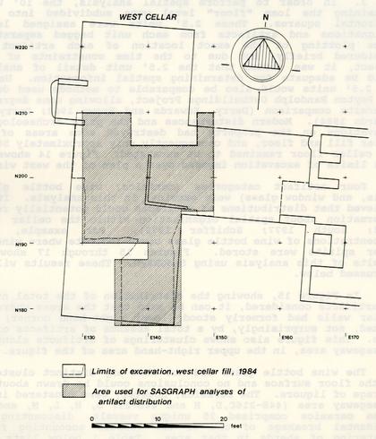 Figure 14. 1984 excavation area superimposed on plan of west wing
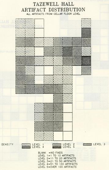 Figure 15. Total artifact distributions from cellar floor
 Figure 16. Wine bottle glass and ceramic distributions from cellar floor
 Figure 17. Window glass and Nail distributions from cellar floor
| Unique Vessel | Vessel Description |
|---|---|
| 023 | Colono-Indian ware bowl |
| 067 | Pearlware plate, blue shell edge |
| 068 | Pearlware plate, blue shell edge |
| 071 | Pearlware plate, blue shell edge |
| 076 | Pearlware plate, blue shell edge |
| 080 | Pearlware plate, blue shell edge |
| 085 | Pearlware plate, blue painted embossed oak leaf edge |
| 087 | Pearlware plate, blue painted embossed oak leaf edge |
| 088 | Pearlware platter, blue painted embossed cherrystone and leaf |
| 109 | Pearlware plate, transfer printed blue with border design attributed to Joseph Stubbs, Burslem, 1790-1829 |
| 111 | Pearlware small plate, transfer printed blue |
| 112 | Pearlware plate, hand painted blue, banded |
| 114 | Pearlware oval platter |
| 118 | Pearlware platter, blue shell edge |
| 127 | Pearlware saucer, hand painted brown |
| 131 | Pearlware saucer, hand painted blue |
| 133 | Pearlware serving dish, blue shell edge |
| 139 | Pearlware bowl, hand painted blue |
| 141 | Pearlware bowl, annular decoration, finger painted |
| 143 | Pearlware bowl, annular decoration, mocha |
| 144 | Pearlware bowl, London shape, annular decoration, mocha |
| 147 | Pearlware bowl, hand painted blue |
| 149 | Pearlware cup or small bowl, hand painted blue |
| 154 | Pearlware cup, hand painted blue |
| 157 | Pearlware can, hand painted polychrome |
| 163 | Pearlware teapot, transfer printed blue |
| 192 | Whiteware bowl, banded polychrome |
| 227 | White salt glaze stoneware tankard |
| 240 | Chinese export porcelain saucer |
| 246 | Chinese export porcelain saucer, underglaze blue |
| 252 | Chinese export porcelain saucer, overglaze black |
| 253 | Chinese export porcelain saucer, overglaze red |
| 271 | Chinese export porcelain teabowl, overglaze gold |
| 272 | Chinese export porcelain teabowl, overglaze red and gold |
| 275 | Chinese export porcelain can, overglaze red and black |
If indeed this area had been used as a location for food storage. Moorehead (1949) states that records indicate the use of the east wing as a kitchen and service area, while the rooms in the west wing were living quarters, most likely bedrooms. The east wing of the house did not contain a basement, so perhaps the passageway section of the cellar was used to store extra tablewares to be used in the dining room. The date span of the ceramics ranges from creamwares popular during John Randolph's occupation of the property to whitewares common after 1820, indicating that the floor deposit accrued over a number of years.
Although nails and window glass were found distributed over the entire surface of the floor, they also showed distinct clusters in the wing passageway. The distributions of glass likely reflect windows broken during the removal of the wing and pressed into the floor surface during salvaging of the foundation walls. The nails found most likely also reflect activities associated with the wing removal. of the 132 identifiable nails from the floor surface, 59.9% were of the hand-wrought variety commonly used prior to the 19th century. The remainder were cut nails, which became common after 1805. The later cut nails could be indicative of 19th-century repairs to the wing, or the construction of the new west wall of the main house, which would have been built when the wing was removed. The nails showed no patterning in length or head type (i.e. rose head, T-head, etc). Included were all varieties of nails, ranging from nails which would have been used for flooring and trim, to nails that would have been used in constructing the house framing. It was hypothesized that the presence of a wooden floor in the cellar could be inferred from large numbers of flooring nails contained in the floor deposit. On the basis of the nails assemblage recovered from the floor deposit, however, it was not concluded that a wooden floor existed in the cellar.
The concentrations of window glass and nails in the passageway may be accounted for by the different treatments given the passageway and the wing during the 1835 renovations. Purportedly, the west wing was moved to the east side of the property and became a kitchen/laundry. The framing of the wing would have remained intact after being removed from its brick foundation and subsequently rolled on logs to the other, side of the property. The passageway, however, was demolished, in 1835, and a new fireplace and bulkhead entrance into the basement constructed against the west wall of the main house. This demolition would have generated much more debris in the form of discarded nails, broken window glass and other architectural debris than the moving of the wing.
Several conclusions can be drawn from the spatial distributions of artifacts within the cellar. The nails and window glass distributions seem to reflect activities occurring during the 1835 renovation and were not a function of activity 52 occurring in the cellar during the lifetime of the structure. The ceramic distribution of fine tablewares clustered in the passageway entrance into the west wing does seem to point to the storage of tablewares in this area. It is not known whether there was a staircase leading to the first floor of the house anywhere near the passageway, which would have facilitated the moving of ceramics from the basement to the upper portion of the house. When James Knight excavated the west wing cellar in 1948, he located the remains of the two interior chimney foundations in the central portion of the wing (see Figure 6). Heavy concentrations of anthracite coal were found in the southern half of the cellar floor fill suggesting that this area was used for the storage of coal. It is known that at least portions of the house were being heated with coal as early as John Randolph's ownership of the property. The spatial distribution of artifacts do seem to indicate that some space within the cellar was being used for different functions, probably relating to storage.
Summary
On the basis of the results of the analysis described above, it is concluded that the dark brown sandy loam represented a gradual accumulation of debris on the cellar floor, rather than comprising a layer of cellar fill deposited in 1835. There was evidence through the presence of crossmends between the floor and upper levels of cellar fill that some of the artifacts from the floor level were associated with the 1835 renovation. These most likely had been pressed into the floor fill during the removal of the cellar and hearth foundations. Most of the ceramic artifacts, however, were types which were common during the end of the 18th century and the first quarter of the 19th century. The wide date range of production for the ceramics recovered from the cellar floor points towards a gradual accumulation of debris, and it was shown that glass and bone from the floor level was significantly smaller in size than the same artifact categories from levels of primary fill within the cellar. This smaller size is accounted for by the trampling effect of traffic on a living surface. The ceramic and glass artifacts from the cellar floor level were also characterized by a lack of crossmends and reconstructable vessels, a characteristic of secondary refuse (Wise 1976:269). Although there was some support for the segregation of storage space within the cellar, the results of the spatial analysis were not clear cut.
Architectural Features
Bulkhead Entrance and Foundation Walls. The bulkhead entrance into the west wing cellar was located along the wing's western wall. In 1948 Knight uncovered and mapped this bulkhead, which was 5.25' wide, 3.5' deep, and composed of eight descending steps only a small portion of the bulkhead was re-excavated in 1984, since the entire area around it had been previously excavated by Knight and was no longer stratigraphically intact. The re-exposed brickwork contained within units 21ON 120E and 21ON 130E supported Knight's identification of the brick as colonial and similar to that of the colonial house foundation.
Little remained of the rest of the brick foundation for the west wing and enclosed passageway. It appeared that the walls were robbed when the wing was removed in 1835, and 1.3'-1.7' wide robber trenches were evident where these walls had formerly stood. A piece of banded pearlware, providing a terminus post quem of 1785 (Noël Hume 1969:131), was found in the robber trench (44B-213).
A small section of wall remained near the bulkhead in the southern part of units 210N, 120E and 210N, 130E. This 2' segment of wall (44B-299) was about 1.3' wide and was composed of a header course between two courses of stretchers. It appears to have continued southward for an undetermined distance beyond this point, past the limits of the 1984 excavation.
Despite the lack of intact foundation walls, portions of the exterior builder's trenches survived. A 0.5' wide strip of builder's trench (44B-177, -178, -183, -191, -257, -280, and -285) was found on both sides of the enclosed passageway and along the west and east walls of the west wing. Since no datable artifacts were found in undisturbed proveniences, however, the excavation of these trenches was not helpful in determining the construction date of the building.
Trench Within Enclosed Passageway. Located beneath the floor level in the west wing passageway, cutting yellow clay subsoil, was a 1.0' wide trench oriented in an east-west direction. The trench had sloping sides and a flat bottom, and was filled with dark brown sandy clay loam. The trench paralleled the robber trench for the covered-way foundation's southern wall, and may be related to the construction of the covered-way. No datable ceramic artifacts were discovered within the trench, but a wine bottle base which corresponds closely to those of the period between 1720 and the early 1730s (Noël Hume 1969:64) was contained within the fill. This bottle crossmended with fragments found within the dark brown sandy loam floor level, thus apparently dating the filling of the trench to the period of this deposit. The trench continued east past the 54 limits of the 1984 excavation, into an area explored by James Knight in 1948. This trench was probably not discovered by Knight, since his archaeological map shows no record of it.
L-Shaped Brick Sill. First exposed by James Knight in 1948, and later re-excavated in 1984, was a line of brick resting on the orange clay subsoil at the very bottom of the cellar (Figure 18). These brick were not mortared, and were very similar in size and color to those of the original house foundation. Although it is possible that they represent portions of an early brick floor for the cellar, their configuration makes it more likely that they represented a sill or support for a wooden floor. These brick were sealed by 1948 backfill in the central portion of the cellar, but at the western extent of the brick were covered by the intact dark brown sandy loam floor. This would seem to suggest that, if a wooden floor was once present, it was later removed and the dark brown sandy loam allowed to accumulate.
Lightning Rod. At the south junction of the west wing and the enclosed passageway, excavation uncovered two iron lightning rod bases driven vertically into subsoil. These had, at one time, formed part of a larger lightning rod system consisting of an underground V-shaped metal rod connected to the two iron bases (Figure 19). A lightning rod cable extended from this V-shaped piece up the side of the house and to the roof.
All portions of the lightning rod except the two iron bases had been previously removed. The 1948 cross-trenching had partially uncovered one of the metal rods, but had left it undisturbed. To the north of the rod and extending toward the corner of the passageway and west wing was the trench from which the V-shaped metal piece had been removed (44B-244). This removal trench contained large quantities of mortar and brick from the wing removal and other artifacts including blue transfer printed whiteware, with a terminus post quem of 1820 (Noël Hume 1969:130). Ceramics within the removal trench crossmended with the layers of cellar fill, indicating that the lightning rod was removed in 1835, when the west wing was moved. The V-shaped portion of the lightning rod was salvaged, but the two metal rods were left descending into subsoil. There was evidence of a square hole (44B-252) excavated around the southernmost metal stake in an effort to remove it but this attempt was unsuccessful. This removal hole contained no ceramics or tightly datable artifacts, but most likely this salvage attempt occurred at the same time as the removal of the west wing.
The iron stakes themselves measured 2.8' long, and contained a loop at one end for connection with the V-shaped rod. These stakes and the construction of the lightning rod appear, on the whole, to be very similar to examples which have been excavated 55 elsewhere in Williamsburg, at Bruton Parish Church (Samford 1983) and the Public Hospital.
Summary
The architectural features uncovered in the 1984 excavation shed little new light on the architectural interpretation of the colonial house proposed by Moorehead in 1949, beyond an exterior lightning rod beside the west wing. Combined with Moorehead's examination of the house, however, a fairly complete architectural reconstruction is possible.
The original building was a one-story structure, though with an unusual two-story central hall. Moorehead reconstructed it as composed of this central hall flanked by two equally-sized l8' x 24' rooms, both with chimneys. Small 8' x 24' galleries led to 17' x 45' two-story wings on either side of the house, connected by 19' long covered-ways. Both wings apparently contained two interior chimneys and fireplaces.
The inventory of John Randolph's possessions (Appendix 1), taken after his departure in 1775, suggests the function of many of these rooms. As Moorehead reconstructed it, the central hall, or "salloon", was flanked by the "drawing room" on the east and the "dining parlour" on the west, and covered by the "upper chamber." The two "galleries" on the north side of the house led to the "passages" (covered-ways). The east wing was reconstructed to contain the "small dining parlour" and an unidentified room with the larger of the two fireplaces, perhaps a kitchen. The west wing contained the "bed chamber" and another unidentified room, which Moorehead suggested might be either another part of the bed chamber or the small dining parlour.
In 1835, when Dickie Galt acquired the property, the house underwent a major architectural renovation. Both wings were removed and at least one was relocated as a free-standing outbuilding on the eastern side of the property. The western covered-way was apparently destroyed, while the eastern one was retained and converted into a chamber by the addition of a chimney (see Frontispiece) . Meanwhile the main house was raised to two full stories, and a bulkhead entrance to the cellar was constructed along its new eastern wall. A new chimney was placed in each of the old "galleries". It is not known whether the functions of the remaining rooms remained the same, although it is likely that the sleeping chambers once housed in the west wing were transferred to the new upstairs rooms.
Little of this architectural reconstruction was directly the result of the 1984 excavation, but this latest investigation of the house was hardly a waste of time. The fill uncovered in the west wing cellar, and the sealed floor of this cellar, were
56
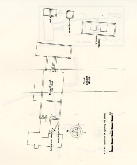 Figure 19. Lightning rod
58
extremely informative. The accumulation of dark brown loam which comprised a floor surface, represented a living deposit of trash and debris from the activities carried on in the cellar. These would appear to have included coal storage, and storage of fine ceramic tablewares.
Figure 19. Lightning rod
58
extremely informative. The accumulation of dark brown loam which comprised a floor surface, represented a living deposit of trash and debris from the activities carried on in the cellar. These would appear to have included coal storage, and storage of fine ceramic tablewares.
The cellar fill was apparently deposited in 1835, when Littleton Tazewell's heirs sold the property to Dickie Galt. It is generally assumed that Galt immediately removed the east and west wings of the house and utilized one as a separate kitchen/laundry, most likely to minimize the fire hazard to the house from cooking activities. In any event, the open cellar hole must have soon been filled, probably after the brick foundation walls were robbed for use in the foundation of the new outbuilding. The fill appears to have been a mixture of soil from the yard, rubble and destruction debris from the architectural renovations, and possibly soil and refuse from the nearby ravine.
B. Testing in the Front Yard
The series of test units placed in the lawn south of the East Wing of the Williamsburg Lodge was designed to identify features in the front yard of the colonial house. Thirteen units were excavated and several features, dating from various time periods, were found.
Among the most important reasons for testing in this area was the evidence of outbuildings shown on both the Frenchman's Map and on 19th-century insurance plats of the property. The Frenchman's Map (1782) shows a large building located to the west of the house along the boundary of the property (see Figure 20). The 1853 Mutual Assurance Society Policy issued to Joshua Walker does not show a building in this location, but does show a wooden outbuilding northwest of the main house (M.A.S. 1853). Both of these were apparently substantial structures, which should have left archaeological traces in the soil, traces which could be revealed through controlled testing. It was also thought likely that fence lines, walkways, and garden features relating to the occupation of the colonial house would be encountered in this area.
James Knight and his excavators had cross-trenched a 35' by 75' area directly north of the house, but found no significant features. With no archaeological information to proceed on, the 1984 test units were placed so as to cover the entire area, but to concentrate most heavily on the sensitive area where the outbuilding(s) were shown. As features were uncovered, a number of the test units, initially 2.5 feet square, were expanded in order to expose and interpret the feature.
Following will be a discussion of the results of this testing.
18th-Century Rubble Layer
A 0.3'-0.8' thick layer (44B-59), possibly associated with the construction of the colonial house, was found in unit 240N 180E (see Figure 21). This layer included brick rubble, shell mortar, hand wrought nails, window glass, oyster shell, charcoal, and coal. Stratigraphic evidence was obscured by one of Knight's cross-trenches, but the rubble layer appeared to be sealed by the marl walkway described below. It was also cut by an early 19th-century posthole (44B-65). Although it lay 20' north of the house, it is likely that this was a remnant of some of the debris generated when the house (or perhaps the front porch) was constructed.
60
Figure 20. Property boundary and outbuilding shown on Frenchman's Map
 Figure 21. Location of 18th century features in front yard
1835 Destruction Layer
A layer of destruction debris (44B-18), found in unit 230N 150E, was interpreted as relating to the removal of the west wing in 1835 (see Figure 22). This 0.02' thick layer contained brickbats, shell mortar, and oyster shell. Ceramics -included Chinese export porcelain, pearlware, whiteware, white saltglazed stoneware, Fulham-type stoneware, and canary ware, with the latest ceramics suggesting a deposition date for this layer around the second quarter of the 19th century. A link to the destruction of the west wing was provided by a small piece of finger trailed annular pearlware, which appears to be a part of a tankard found in the cellar fill (U.V. #162; see Figure 23A). Even further corroborative dating evidence was provided by a pewter spoon handle from the layer, which bears the engraved mark "W(m.) MIX" (Figure 23B). This spoon was made by William Mix of Prospect, Connecticut, who was in business during the period 1827-1850 (Laughlin 1981:219).
Marl Walkway
A marl walkway or driveway associated with the colonial house was also located through testing in the north yard. The full extent of this feature was not traced, since the planned construction was not going to impact this area. However, it appeared that the marl may have extended as a circular path in front of the house. Figure 24 shows the extent of the walkway as revealed by testing. Averaging 0.3' in thickness, the marl thinned to 0.05' along the sides of the walkway. There was no evidence that a trench had been excavated for the construction of this marl path appearing instead that marl had simply been spread on the ground surface in the areas where the walkway was needed.
Just north of the west wing (in unit 230N 150E), the marl was sealed by the 1835 destruction layer (44B-18), thus dating the deposition of the marl prior to this time. Among the most interesting artifacts included in the marl layer was canary ware, an earthenware with a bright yellow lead glaze. The production of canaryware began roughly around 1785 and was popular until 1835 (Miller 1974:11).
Pressed into the top of the marl, but possibly deposited with the 1835 destruction layer, was a 1724 British halfpenny covered on both sides with shell mortar (Figure 25). The mortar suggests that the coin was placed within the foundation of the West wing during its construction around 1762, either intentionally or accidentally. When the wing was removed in 1835, it was dislodged from the mortar and brick in which it was set, and lost during the destruction.
63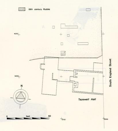 Figure 22. Location of 19th century features in front yard
 Figure 23A. Finger trailed annular pearlware
Figure 23B. Pewter spoon marked "W (m.) MIX"
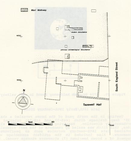 Figure 24. Location of marl walkway in front yard
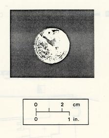 Figure 25. 1724 British halfpenny found in marl walkway.
Late 18th/Early 19th-Century Ditch
Testing in the north yard of the house revealed a shallow, 0.351 deep drainage ditch (44B-53 and 44B-54) oriented in a northeasterly direction. measuring 2' wide with gently sloping sides, this ditch was sealed by remnants of the marl sidewalk and contained late 18th-century ceramics such as pearlware and creamware. Also included in the artifact assemblage was a fragment of a brown American (?) stoneware storage vessel, which could possibly date to the 19th century.
Modern Fill
In an effort to locate the structure seen to the west of the main house on the Frenchman's Map (1782), three test units were excavated directly east of the South Wing of the Lodge. Projecting the Frenchman's Map onto a present-day map of the Lodge property shows this to be the area where archaeological remnants of this structure would be expected (see Figure 20).
67Each unit contained a series of 0.9' to 1.3' thick layers of modern fill (44B-66, -68, -69, -71, -72, and -74) associated with the construction of the South Wing of the Lodge. These layers consisted of brownish grey to light yellowish brown sandy loams mottled with yellowish brown sandy clays, and contained gravel and pebbles. Sealed by these layers of fill in unit 240N 60E was a thin layer of cinder (44B-86), which contained. a 1938 U.S. nickel. This cinder was most likely associated with the 20th-century Tazewell Hall, and is thought to represent an area where household trash was burned. Also in the immediate vicinity was a concentration of modern, trash including oyster shell, bone china, glass, and nails (44B-85), which was believed to represent debris from the Peyton Randolph Nelson occupation of the site in the early 20th century.
Unfortunately, no traces of the late 18th-century structure depicted on the Frenchman's Map were located through testing. since this area was not going to be impacted by the construction of the new guest facilities, testing was kept to a minimum. Remnants of this building may have been completely destroyed by the construction of the Lodge's South Wing, but further testing to the north could still reveal traces of this structure.
Modern layers associated with the construction of the Lodge were also found north of the colonial house, in unit 280N 180E. A 0.3' thick layer of brown sandy loam (44B-23), containing relatively few artifacts, was underlain by a 0.5' thick layer of pale brown loamy sand (44B-25). Artifacts from this loamy sand layer included a variety of 18th- and early 19th-century ceramics (English delft, pearlware, white saltglazed stoneware, and Chinese export porcelain) as well as more modern items (an embossed pharmaceutical bottle, machine made nails, etc.). It is likely that both these layers are associated with the site disturbances caused by construction of the East Wing of the Lodge, some 40 feet to the north.
Summary
Testing in the front yard of the house was not successful from the standpoint of locating former outbuildings. It did, however, provide adequate evidence for an assessment of the current potential of this area for archaeological remains. Although the northern boundaries of the lawn appear to be disturbed and devoid of 18th and 19th century cultural fill, the central and western portions revealed stratigraphic sequences which would aid in answering questions concerning the 18th and 19th century spatial configurations on the Tazewell Hall property.
Among the important features was a late 18th or early 19th-century marl walkway, which may have formed a circular path 68 in front of the house. Partially sealed by a layer of destruction debris thought to date to Galt's renovations in 1835, it would appear to have been in use up to this time. The walkway probably served as a means of access from Francis Street, and probably extended to the front porch of Tazewell Hall.
Two earlier features were also found in the area: a layer of brick rubble and a shallow drainage ditch. The rubble layer is probably associated with the construction of the front porch, being located some twenty feet northwest of this area. The drainage ditch, tending northeast-southwest, may have separated the front yard into areas of differing functions and appeared to have been filled in the late 18th or early 19th century.
C. Boundary- Ditch
Among the final discoveries of the 1984 season was a 0.3'-1.0' deep ditch running north-south, some 30' west of the west wing of the colonial house (Figure 26). The ditch, intruded by the southwestern corner of the 1908/1909 house foundation and numerous 20th-century utility trenches, appeared to run the entire length of the project area.
The ditch varied in size along its length, with the southern extent only 1.51 wide and 0.31 deep. Its fill consisted of a relatively sterile brown sandy loam, containing few artifacts but a great deal of charcoal flecking. Due to time considerations only a 2' long section was excavated in this area (44B-522). The northern part of the ditch, adjacent to the 18th century house, however, was at least 5.5' wide and 1' deep. This discrepancy in size and depth may possibly be accounted for by differential grading during the parking lot construction, but there was another important difference between the two excavated sections. Unlike its southern portion, the fill of the northern extent of the ditch was composed of an olive brown sandy loam containing rich deposits of brick, mortar, oyster shell, charcoal, and bone. A large number of artifacts was also contained within this fill, including creamware, delftware, white saltglazed stoneware, Chinese export porcelain, several types of coarse earthenwares and stonewares, and numerous wine bottle fragments. A 301 long section was excavated (44B-513, -514, -515, -516, and -517) and over 1600 artifacts collected.
The orientation of the ditch suggests that it was constructed as a property boundary by an occupant of the colonial house. A terminus post quem of 1769 (Noël Hume 1969:126) was provided by the inclusion of creamware, the latest ceramic within the assemblage. The total absence of common later ceramics such as pearlware (introduced in 1779) suggests that the ditch was filled during the period 1769-1779, most likely after John Randolph abandoned the property in 1775.
The artifacts were clustered in the section of the ditch located just west of the colonial house site. Since these artifacts were probably associated with the end of John Randolph's occupation of the property in 1775, they offer a tightly datable assemblage with which to analyze John Randolph's material possessions.
Using South's (1977) pattern analysis as a mechanism to organize the assemblage, it is seen that there is a high percentage of kitchen related artifacts and relatively few architectural artifacts within the group. Approximately 85% of the ditch assemblage was composed of ceramics and glassware, as
70
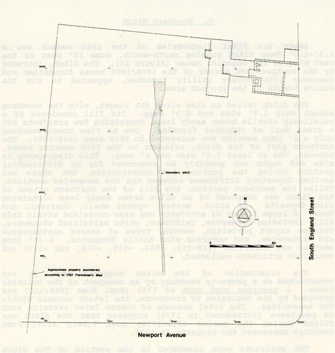 Figure 26. Boundary ditch
compared to 14.6% for architectural items, such as window glass, nails, and architectural hardware. Further analysis of the ceramics shows that 51.5% of the 33 unique vessels recovered from ,the ditch were tableware forms, compared with 30.3% toiletwares and 18.2% food preparation or storage vessels.
Figure 26. Boundary ditch
compared to 14.6% for architectural items, such as window glass, nails, and architectural hardware. Further analysis of the ceramics shows that 51.5% of the 33 unique vessels recovered from ,the ditch were tableware forms, compared with 30.3% toiletwares and 18.2% food preparation or storage vessels.
The fine tableware, representing 17 unique vessels, can be further separated into creamware, white saltglazed stoneware, and Chinese porcelain. Creamware was most prevalent, not only in the number of unique vessels (8), but also in raw sherd count (286). This was followed by white saltglazed stoneware (6 vessels, 28 sherds), and finally Chinese export porcelain (3 vessels, 35 sherds). The relative preponderance of creamware and white saltglazed stoneware vessels over porcelain may well reflect the fact that creamware and white salt glazed stoneware were used more as everyday tableware within the Randolph house, and were thus more likely than the porcelain to be broken.
Randolph's schedule, included in the indenture between Randolph and his trustees, lists the contents of Tazewell Hall as Randolph left it when he fled to England in 1775 (see Appendix 1) . In addition to the opulent furnishings, such as mahogany furniture, carpets, and looking glasses, many ceramics were described in detail. Most common in the schedule were references to Chinese porcelain, with decoration both in blue underglaze designs and with red overglaze motifs. Both types of porcelain were included in the ditch fill. Especially interesting is reference in the schedule to "nine red and white China Turene and dish, fourteen plates Ditto," and "eight red and white China dishes." Fragments of a porcelain bowl and a small plate, both decorated in red overglaze floral motifs, were contained in the ditch assemblage (U.V. #406, U.V. #407). Also mentioned in the schedule, and found abundantly in the ditch, was "Queens Ware," an 18th-century terminology for creamware (Noël Hume 1969b: 124). It is interesting to note that of all the ceramic types found in the ditch, only creamware and porcelain were mentioned specifically in the inventory. These were high status ceramics, more likely to be contained and displayed in the main house, while the other forms, such as storage wares, would have been located elsewhere on,the property.
The presence of teaware both in the schedule and in the ditch assemblage, is a reflection of an important aspect of colonial social life. The tea ceremony in the British colonies had an established set of manners and distinctive accoutrements (Roth 1961). Its importance to Randolph is reflected in his schedule by the contents of his drawing room. Items associated with tea drinking included "one handsome wrought Tea Table, one round carved Mahogony Tea Table, one Mahogony Stand for a Tea-Kettle," and "one compleat set of Nanquin Tea China." Here it is seen that the teaware is located in the a room where the majority of social functions likely took place. Located 72 elsewhere in the house were "five China Chocolate Cups and eight Saucers, one Tea Box, one Tea Chest, one Copper Tea Kettle, and one Copper Tea-Kitchen."
The total absence of tobacco pipe fragments from the ditch is surprising. Tobacco pipes are a common item in most 18th-century deposits and, according to Stanley South's Carolina Artifact Pattern (1977), usually comprise between 1.8% and 13.9% of the total artifact assemblage of domestic sites, with a mean of 5.8% (South 1977:117). Although the assemblage ranks high in kitchen-related artifacts, it appears to be otherwise characteristic of a domestic assemblage, with the exception of the complete lack of pipes.
Also included in the ditch fill were pieces of anthracite coal. It has been hypothesized that the house, or at a least portion of it, was heated by coal during the Randolph occupation of the property. Some support for this comes from Randolph's schedule, which lists "one grate and Fender handsomely Wrought" in the drawing room. It would not have been unusual for John Randolph to use coal for heating, as many Virginia residents had coal grates by the mid-18th century (Goodwin 1963:5). The presence of coal in Randolph's trash deposits, as well as on the floor of his cellar, would be expected if this sort of heating system was used.
Summary
This feature can be evaluated in terms of the changing landscape needs of the property through time and across ownership. The boundary ditch was constructed on the property sometime during the Randolph period and perhaps served to separate the formal back yard from a more utilitarian portion of the property. This separation of the two portions of the property continued into the 19th century. The western side of the Tazewell Hall property can be seen on a pre-Civil war watercolor (Figure 27) as a cleared area, separated from the immediate back yard by a fence. Abutting the fence is a large wooden outbuilding, appearing to be a stable or barn. This may be the same structure as that depicted to the west of the house on the Frenchman's and the Desandrouins Maps. More of what appear to be farm-related outbuildings appear to the north in the watercolor. It is evident that the western portion of the property, throughout its history, served utilitarian functions, perhaps as fields for grazing livestock or as agricultural lands. By the mid-19th century, this portion of the property was separated from the main house yard by a fence, although during the 18th century, a boundary ditch apparently served the same separating function. Although cleared by the 19th century, the vegetation of the western portion of the property during the 18th century, and thus Randolph's use of this area, is not known. Archaeological monitoring of the excavation of the area west of 73 the boundary ditch did not reveal any cultural material in the form of structures, features, or artifacts, and upholds the hypothesis that this portion of the property served as agricultural or grazing lands during the 18th and 19th centuries.
The composition of the artifact assemblage from the ditch is varied, comprised of numerous types of ceramics, glass and other household items. The ceramics include both fine and coarse vessels, including those which would be used in the preparation and serving of food, the entertaining of guests, and daily toiletry. Also included were items of architectural hardware, such as locks, keys, window glass, and nails, as well as large quantities of anthracite coal. The varied nature of this assemblage seems to suggest that this deposit was not related to specialized activity on the site, such as a renovation or the garbage generated by kitchen or stable activities. Rather, it is hypothesized here that the deposition was associated with a general clean-up of the property after it changed owners. Given the complete absence of ceramics commonly present on British colonial sites after 1779, it appears likely that the filling of this ditch took place before this time and was probably associated with the purchase of the property by John Tazewell in 1778. When Randolph fled Williamsburg in 1775, he left his home and its furnishings intact, having arranged for his brother Peyton to sell his estate. With the sale delayed for almost three years, the property sat, most likely virtually untouched, from the time Randolph left until its purchase by John Tazewell. For whatever reason, Tazewell no longer wanted the boundary ditch to remain open, and it was filled with the debris from a general cleaning of the property. Thus the ditch assemblage provides a glimpse of Randolph's discarded possessions, rich in social ceramics like porcelain teawares, and other high-status items of the third quarter of the 18th century, such as queensware and ornate shoe buckles.
74
Figure 27. Williamsburg, VA: South View showing Tazewell Hall
D. Fence Lines
At least three definite fence lines were uncovered in the lot behind Tazewell Hall. Fence lines are distinguished by similar, regularly-spaced groups of postholes, often forming an obvious enclosure. These features are among the most important discoveries for landscape reconstructions, since they delineate property boundaries or internal subdivisions within a garden or yard.
Fence Line 1
An east-west running fence line, composed of seven postholes (Features 37-43), was located 145' south of the 18th-century house (Figure 28). Spaced so that the posts would be located eight feet apart, the rectangular postholes measured between 1.7' and 2.0' N/S and 2.0' and 2.5' E/W. Approximately two-thirds of each hole extended to a depth of 0.8' to 1.0' below the bottom of the parking lot base. The remaining portion, always on the east side of the posthole, extended to a depth of only 0.5', giving each posthole a stepped appearance. The postmolds, measuring 0.6' to 0.9' in diameter, were contained within the deeper portion of the postholes. Fill within each posthole was consistent throughout, suggesting that the stepping was original to the construction of the fence line and did not represent repair or post removal holes. Ivor Noël Hume (personal communication 1984) has suggested that this stepped appearance was a natural result of digging a small deep hole. Excavating a larger area than needed near the top of the hole was necessary in order to be able to maneuver the shovel while digging the deeper portions of the hole.
No ceramics were located within the posthole or postmold fills of Fence Line 1. However, a machine-made nail with a hand-wrought head, contained in posthole 44B-418, provided a date of post-1805 for the construction of this hole and, by implication, the fence line itself. Similar nails were also located within the postmold fill, although this fill was deposited somewhat later after the post had rotted or been removed.
Archaeological feature containing little or no datable artifactual material are often dated relative to the artifacts within various soil layers which they cut through or which seal them. At the Tazewell Hall site, almost all cultural stratigraphy had been stripped away during the construction of the parking lot, making this form of dating usually impossible. In the case of Fence Line 1, however, it was possible to use
76
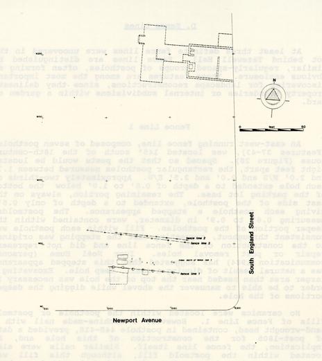 Figure 28. Fence lines
other archaeological features to aid in dating the construction and use of this fence.
Figure 28. Fence lines
other archaeological features to aid in dating the construction and use of this fence.
Two postholes of Fence Line 1 (Features 37 and 38) cut the planting bed (Feature 13), which most likely dated to John Randolph's occupation of the property (1758-1775). This means that the construction of the fence line postdated the construction, and likely the abandonment, of the planting bed. Another posthole (Feature 40) was cut by Feature 60, suggesting that the fence line was no longer functional at the time Feature 60 was constructed. Since the artifacts in this feature indicate that it was constructed sometime after 1820 and filled in 1835, it is probable that Fence Line 1 was in use sometime during the first quarter of the 19th century, and certainly abandoned well before 1835. Thus, through associations with other features on the site, relative dating of this fence line was possible.
The fence line most likely represented an internal property division, perhaps serving to divide the formal yard (per se) from other portions of the Tazewell Hall property to the south. Dating evidence suggests that it was built by Littleton Tazewell, and possibly was abandoned after his death in 1815 when his wife and daughter moved to Mecklenburg County and.left the property in the hands of a tenant or overseer.
Fence Line 2
A second fence line, lying 1201 south of the colonial house, was located 251 north of Fence Line 1 (see Figure 28). The eight ovate to round postholes (Features 45-52) were smaller, ranging from 1.0' to 1.5' in diameter and 0.65'-1.0' deep. They were spaced fairly regularly, 6-7' apart, and contained 0.5'-0.65' diameter postmolds. The smaller size 'of the postholes and postmolds suggests that a less substantial fence was erected here than along Fence Line 1. A terminus post quem of 1805 for the posthole fill was obtained from machine-made nails with hand wrought heads contained within two of the holes (44B-358 and 44B-377). Due to the lack of site-wide stratigraphy, however, it was impossible to determine whether this fence predated or postdated Fence Line 1.
Fence Line 3
Fence Line 3 consisted of seven postholes (Features 44, 53-57, and 88), located less than 51 south of Fence Line 2, but along the same east-west orientation (see Figure 28). These squarish postholes ranged from 1.0'-1.3' in size and 0.8'-1.0' deep, with 0.5'-0.65' postmolds. They were spaced 11-12' apart, at much wider intervals than the holes of Fence Lines 1 and 2. 78 The wide spacing and large, deep holes suggest that the fence must have been fairly substantial, although probably not as large as that of Fence Line 1. A terminus post quem of 1805 was obtained from a machine-made nail in the fill of posthole 44B-407. Again, however, there is no indication whether it predated or postdated the other two fence lines.
Summary
The purpose of these three fence lines apparently relates to some internal division within the back lot of the property. The original Randolph property, shown on the Frenchman's Map, extends to approximately 450' south of Fence Line 1. It does not seem to have been legally subdivided until May 1906, when the property was separated into lots, streets, and alleys (City of Williamsburg n.d. 2:4).
These fences, therefore, must have subdivided the back yard, either enclosing a garden area or some sort of pasture. Since all three fence lines extended past the edges of the project area on both the east and west, the exact shape or size of the enclosure could not be determined. The fact that one side of each fence was at least 75' long, however, suggests that the enclosure(s) must have been fairly large.
Other archaeological features within the confines of the fence lines were suggestive of a formal yard and garden located south of the house, with remnants of walkways and planting areas. It is entirely possible that the fence lines represented sequential boundaries separating the Tazewell mansion from a pasture or wooded area. Since only the extreme northern section of the area south of the fence lines fell within the project area, little is known about its character.
The sequence of fence construction and removal is equally unclear. Artifactual evidence in the posthole fills indicated that all were constructed after 1805, and Fence Line 1, at least, was probably abandoned by 1835. The other two fences, however, may have been built and in use at any time in the 19th century.
E. Garden Features
Introduction
The prospect of well-preserved garden remains was among the most potentially-enlightening possibilities of the Tazewell Hall project. The excavation of John Custis' gardens in 1964 revealed important details of 18th-century Williamsburg gardens (A. Noël Hume 1974), but few other gardens in the city have been extensively studied. John Custis, however, was the epitome of the gentleman gardener, perhaps equalled only, in Williamsburg at least, by his neighbor and friend John Randolph.
John Randolph seems to have been as proud of his gardening ability as of his law practice. He is reputed to have authored a manual of his horticultural techniques entitled A Treatise on Gardening by a citizen of Virginia (Warner 1924). The first gardening manual to be published in the United States, Warner suggests that the volume was written between 1760 and 1770, which would have been during Randolph's residence at Tazewell Hall (Warner 1924:x). In this manual, Randolph gives explicit instructions on the proper methods of vegetable and herb gardening in Virginia. These methods were tested through years of experimentation, probably on the Tazewell property, and it was expected that Randolph's garden experimentation would leave traces visible as archaeological remains.
Various 18th-century maps, such as the Frenchman's Map (Figure 29) and the Desandrouins Map (Figure 30), depict what appears to be an enclosed garden located to the south of Tazewell Hall. Archaeological excavations were expected to uncover remains of this garden, in the form of walkways, planting beds, and tree and shrub holes.
The 1984 excavations did reveal garden remains at Tazewell Hall, extending south up to 1501 from the main house (Figure 31). Archaeological remains were not as numerous as expected, however, due for the most part to mechanical grading which had taken place there when the Williamsburg Lodge parking lot was constructed. Up to 1' of soil was removed from what had been the south yard, and only those features which had cut through subsoil remained. All evidence of walkways and shallow planting beds would have been destroyed, and only features which would have left more substantial evidence in the soil, such as terraces, were left. Although this was disappointing, traces of several important features were uncovered and these are discussed below.
80
Figure 29. Detail of Frenchman's Map showing Tazewell Hall garden
Figure 30. Detail of Desandrouins Map showing Tazewell Hall garden
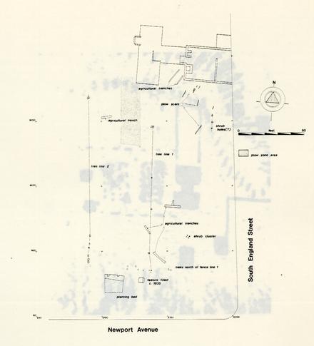 Figure 31. Garden features at Tazewell Hall
Planting Bed
Part of a rectangular planting bed was discovered in the southwestern corner of the project area (Figure 31). The exposed portion was 13.5 N/S by 14' E/W in size and was bounded by concrete parking lot curbs on the south and west. These curbs were later removed, and traces of the planting bed appeared at least 101 west of the curb. Although no more of the bed could be exposed, these traces indicate that the bed was originally at least 14' N/S by 23.5' E/W in size.
Other modern disturbances including a brick sump box and concrete drain pipe, also intruded the planting bed. Fortunately these features caused little disturbance except to the areas immediately around the box and pipe on the south side of the bed, and the spatial arrangement of the bed was left intact.
The bed was two-tiered, With the smaller northern section reaching a depth of 0.8' below the bottom of the parking lot base and the southern section only 0.5'. It was filled with a rich dark brown loam containing bits of oyster shell, bone, and charcoal. The loam retained moisture extremely well, and was still moist long after the surrounding subsoil had dried. Flotation analysis of a soil sample from the bed revealed very little seed, however, and it is likely that the identity of the plants grown in this bed will never be known.
The dating evidence suggests that the bed was constructed in the 18th century, probably during Randolph's occupation. A terminus post quem of 1740 was obtained from a piece of white saltglazed stoneware, and pieces of English delft and Fulham-type stoneware were also contained within the fill. Two postholes of Fence Line 1 intruded the bed, indicating that the planting bed was abandoned before this fence line was constructed. By other evidence, it is known that Fence Line I was built after 1805 and was probably no longer in existence by 1835, so it follows that the planting bed was not used after 1835, and possibly was abandoned during the last quarter of the 18th century or the first quarter of the 19th.
Similar planting beds have recently been found elsewhere in Williamsburg, most notably behind the Peyton Randolph House (Andrew Edwards, personal communication 1985). As with these beds, the soil in the Tazewell Hall bed seemed to retain moisture better than the surrounding area and therefore would have provided an excellent medium for plant growth. Unlike the Peyton Randolph beds, however, the example at Tazewell Hall was not lined with wine bottle glass or bone and shell. For a more complete discussion of the Peyton Randolph planting beds, see Edwards (1986).
Stake Holes.
Located to the southwest of the colonial house was a series of small rectangular holes. Measuring 1.5" by 1.0", these 73 features were, for the most part, arranged in a semicircle extending from the south end of the west wing (Figure 32). Excavation of several of these features revealed that they reached a depth of 0.5' to 0.6' below the base of the parking lot, had pointed bottoms and were filled with a light yellowish brown ash. Due to their regular spacing and semi-circular patterning, it was at first believed that these represented holes where flower bulbs had been planted. The small size of the features, however, coupled with the discovery of their pointed bottoms, makes this fairly unlikely. It seems possible that these features represent places where wooden stakes had been driven into the ground. Although the purpose these stakes may have served is not clear, it is likely they functioned in a gardening sense, perhaps representing an edging for a walkway or path, or serving as support for flowers or climbing plants.
Although the stake features clustered in a semicircular pattern around the end of the west wing, several holes were located outside this area, perhaps suggesting that they did not all date to the same period. Dating of these features, as with others on the site, proved to be difficult, since all overlying stratigraphic layers had been stripped when the parking lot was constructed. Therefore, these features could date any time from the 18th to the 20th century. They were located in what would have been the front yard of the 1908/1909 house, and it is likely that they were associated with the Susannah Garrett/Peyton Randolph Nelson occupation of Tazewell Hall. Photographs of the front of the 1909 house show a line of what appear to be day lilies extending east from the front porch of the house (Colonial Williamsburg Photographic Record n.d.). It is possible that the stake holes were created by a border or edging around flowers beds similar to these.
Clay-Capped Feature (Feature 60)
A rectangular 3.8' N/s by 4.5' E/W feature was found some 11' east of the planting bed, near the southern edge of the project area (Figure 31). The feature extended 0.5' below the bottom of the parking lot with fairly straight sides; its original depth below ground surface was probably 1.5'-2.0'. The feature was filled with a dark grayish brown loam containing shell, brick, and charcoal. Included in this fill was a piece of a brown transfer printed whiteware plate with a Ridgeway "Italian flower garden" pattern (U.V. #172), matching more complete pieces found in the west wing cellar fill (Williams 1978:302). Although 85 this pattern appeared to have been purchased as a set of tableware, there is no evidence that the fragment found in this feature was necessarily part of a plate-deposited with the cellar fill. It can be concluded, however, that this fill was probably deposited by the occupants of the household which filled the cellar.
The western two-thirds of the feature was capped with a 0.4' thick layer of brownish yellow silty clay (44B-422), appearing similar to that used to fill the cellar in 1835. This layer included a fragment of blue transfer printed whiteware, which appears to be part of a bowl found in the cellar fill (U.V. #188). Since these fragments do indeed appear to be part of the same vessel, this convincingly argues that Feature 60 was probably filled with the same material and at the same time as the west wing cellar.
The purpose of the feature is less easy to discern. It may have been a privy pit, abandoned when the west wing was removed and perhaps relocated elsewhere on the property. If so, it was a fairly shallow pit for this sort of feature, probably reaching no more, than 2.5' in depth below ground surface. Another possibility is that this was the remains of a cold frame, used to enable plants to survive the winter.
Parasitological analysis of the fill was undertaken to provide a clearer answer to these questions. Performed by Dr. Karl J. Reinhard of Texas A & M University, this analysis revealed that no parasites were present in the grayish brown loam (Appendix 9). Reinhard (personal communication 1985) therefore believes that the feature was probably not a privy. The most likely alternative, then, is that this was a cold frame or some other sort of garden feature. It clearly long post-dated Randolph's occupation of the property, probably being used by whomever occupied the property before it was sold to Dickie Galt in 1835.
Plow Scars
Some 15 plow scars (Features 14, 15, 17-21, 23-25), most running southwest-northeast, were found in the project area (Figure 31). At least two of these scars (44B-123 and 44B-148) were probably cut by the colonial house, and therefore would have predated the construction of this building around 1762. This area was highly disturbed during the 1948 Knight excavation, however, and the exact relationship of these features to the house foundation could not be determined.
Only 8 of the 15 plow scars were excavated. These scars were 0.3'-0.4' wide and uniformly shallow, extending only some 0.3' below the bottom of the parking lot base. Clearly many of 87 the features were destroyed when the parking lot was constructed. All had V-shaped sides and tended to be less than 7' in length, fading out gradually at each end. All but the two plow scars cut by the house foundation were filled with a brown loamy sand containing fragments of brick, shell, and charcoal. Few artifacts were found in any of the scars, and these consisted only of two pieces of glass, a hand-wrought nail, and a brass upholstery tack.
Although two of the plow scars were cut by the house foundation and therefore had to predate the construction of the house, it is most likely that the remainder of these plow features postdated this period. This conclusion is based on the presence of brick, shell, charcoal and artifacts in these features. There is no record of any cultural activity on this site prior to the construction of Tazewell Hall, and it would be highly unlikely that any plow scars predating the house would contain any cultural material.
Plowzone
In an area 30 to 45' south of the west wing, a small portion of soil stratigraphy remained intact despite the mechanical stripping of the parking lot. This area revealed what appeared to have been a plowzone, composed of brown sandy loan with shell, bone, brick, marl, and charcoal inclusions. This plowzone was sealed by the parking lot fill and sealed sterile subsoil. Artifacts contained within the plowzone were of mixed 18th- and 19th- century dating, with the ceramic assemblage suggesting that the plowing dated after 1860. This area is shown on a 1947 map of the property (McManus 1937) as an orchard of fruit trees, and most likely the plowing and preparation of the soil here related to the planting and maintenance of these trees.
Narrow Agricultural Trenches
Two parallel trenches (Features 16 and 22), 5' apart and running southwest-northeast, were found on the west side of the colonial house (Figure 31). Both were out by the builder's trench for the foundation, indicating that they predated the construction of the house.
The trenches were 0.8' wide and cut at least 0.5' into subsoil, with V-shaped sides and flat bottoms. No artifacts were found within the dark grayish brown sandy loam fill, which did contain a bit of charcoal. It seems likely that these were agricultural features, perhaps suggesting that someone, probably 88 Randolph, was experimenting with gardening on the property before the house was built.
Other Agricultural Trenches
Located near Fence Lines 2 and 3, two deep trenches ran northwest-southeast, in exactly the opposite direction as the plow scars and narrow agricultural trenches described above (Figure 31). One (Feature 29) was at least 7.5' long, 1.0' wide, and cut at least 0.9' into subsoil. No artifacts were found in the brown sandy loam fill. The other (Feature 28) was 12.5' long, 1.3' wide, and cut at least 0.7' into subsoil. It contained a piece of creamware and a machine made nail with a hand wrought head, dating the filling of this trench to after 1805.
A third trench (Feature 30), located just east of the boundary ditch and running east-west, was at least 7.5' long, 1.1' wide, and cut at least 0.7' into subsoil. The brown sandy loam fill of this trench contained two pieces of creamware, a wine bottle fragment, several pieces of window glass, and two machine made nails. A single piece of colorless non-leaded glass dated the filling of this feature to after 1864.
The functions of these three trenches may have been different, although all were approximately the same width and depth. They were interpreted as planting trenches based mostly on their location within the garden, but clearly at least two of the three were filled long after Randolph had abandoned the property.
Among the unusual features located to the south of Tazewell Hall was a trench oriented on a north-south axis (Feature 26). Varying in width from 1.0' to 2.0', the trench was filled with a mottled brown sandy loam and had slightly sloping sides and a flat bottom. Unlike other agricultural trenches located on the property, however, the depth of this trench varied, sloping down from north to south. At the north end the trench cut 0.15' below the bottom of the parking lot base, increasing to 0.9' at the southern end. A sherd of whiteware provided a terminus post quem of 1820 for the filling of this feature. Though it is possible that this feature is connected with garden activity on the Tazewell Hall property, the sloping bottom of the trench suggests that it functioned as a drainage trench of some sort.
The north-south trench was cut at its southern end by an east-west running trench (Feature 27) similar to the three trenches (Features 28-30) described above. This 12' long trench had slightly sloping sides and a flat bottom, extending 0.9' into the subsoil below the parking lot. A terminus post quem of 1864 was provided by a piece of colorless non-leaded glass located 89 within the fill. This trench was also probably associated with garden activity on the property, and, being oriented in the same direction, perhaps had the same purpose as Feature 30.
Shrub-Lined Walkway
A shrub-lined walkway leading south from the colonial house was represented by a. layer of marl and a series of shrub holes (Figure 31). only shrub holes near the house foundation were located, but since the area farther south could not be stripped and archaeologically excavated due to construction scheduling and the presence of a modern sidewalk, any shrub holes farther to the south could not be located. A series of test holes placed just west of the sidewalk, however, was able to trace the marl walkway as far south as Newport Avenue.
Trees or Shrubs North of Fence Line 1
Located along an east-west axis, 1451 from the main house, was a series of planting holes (Features 61-62, 64-71). These appear to represent areas where shrubs and plants were located along the north side of Fence Line 1 (Figure 31). Although the features were mostly devoid of artifacts, the inclusion of a machine made nail with a hand wrought head, similar to those found in Fence Line 1 , would seem to suggest that Fence Line 1 and these planting holes may have been roughly contemporaneous. It is possible that these represented a screen planting along the fence.
Tree Line 1
A line of tree holes (Features 63, 72-74) was located running north-south in the back yard of the colonial house (Figure 31). The trees were spaced from 251 to 351 apart, and were represented by deep narrow holes filled with grayish brown sandy loam. The depth and narrow diameter of the holes suggests trees or shrubs which contained taproots, as opposed to a spreading root system.
Tree Line 2
A second line of tree holes (Features 75-80, 89-91) was found along the west side of the boundary ditch (Feature 34). Three of the holes, near the 1908/1909 house foundation, intruded into the ditch fill and therefore probably postdated Randolph's occupation of the property. Six other tree holes, only three of which were excavated, were found west of Fence Lines 1-3 and west of the edge of the boundary ditch. The large area between these 90 two clusters of holes was damaged by construction activities and could not be archaeologically excavated, so any holes in this part of the site were undiscovered.
The excavated holes contained relatively few artifacts, but included creamware, Chinese export porcelain, lead glazed redware, wine bottle fragments, and a clay pipe bowl with the impressed letters "WM." The tree line clearly postdated the use of the ditch, but these artifacts are not helpful in determining a clearer use date. It is likely that these were fairly late features, however, and at least the southern cluster may have been the "hedge of small trees" described on a 1937 landscaping plan (McManus 1937).
Shrub Cluster
Located 120' to the south of the colonial house were four features grouped in a trapezoidal pattern (Figure 31). These round holes, all approximately 0.5' in diameter, were filled with dark brown sandy loam. Three of these features (Features 64, 66, and 67) had flat bottoms and straight sides, and varied in depth from 0.35' to 0.8'. The fourth feature (Feature 65) contained at its bottom a soil discoloration that, upon excavation, appeared to represent a taproot stain. All four holes were extremely consistent in shape, and gave the impression of possibly being dug with a post-hole digger. It is postulated that these features represent holes where small shrubs were planted. There were no artifacts within the fill of these features to suggest dating, and no similar arrangements of features in the remainder of the project area.
Summary
The lack of good stratigraphic control significantly complicates any attempt at periodization of the garden features at Tazewell Hall. While a few, notably the planting bed, clearly seem to fall within the Randolph tenure (1758-1775), the great majority seem to post-date Randolph's occupation of the property. Undoubtedly the gardens were much more extensive than shown here, and it is most unfortunate that the grading of the parking lot removed so much of the archaeological evidence.
F. Rectangular Features
Description
Mechanical stripping of the southernmost bay of the parking lot revealed two large rectangular features cutting through the subsoil below the parking lot base (Figure 33). These features were oriented with their longest sides on an east-west axis and were spaced 0.8' apart. The northern feature (Master Context C01) measured 7.6' E/W by 3.1' N/S, and was filled with yellowish brown silty clay mottled with very pale brown and brownish yellow sandy loam. The southern feature (Master Context C02), containing the same fill, measured 7.8' E/W by 3.4' N/S. These features were located 122' south of the house, and oriented in the same direction as the three east-west fence lines found on the property. Several disturbances, such as a utility trench and what appeared to be small planting holes, cut through the features.
The shape, size, fill, east-west orientation, and distance of these features from the house seemed to suggest that they represented human interments. Although no documentary evidence had then been located to support this conclusion, the excavation of these features proceeded as if they did indeed contain human burials.
Excavation Strategy
Sensitivity toward human interments demands that graves, if possible, remain undisturbed, and if they must be excavated, that the remains be treated with care and reverence. Since the two features looked like possible graves, it was necessary to proceed carefully. Clearly they had to be excavated, as the soil of the entire area was to be removed to a depth of 25' below grade for the Lodge Addition. The only alternative was that the human remains, if any, be removed and reinterred elsewhere.
Initially it was necessary to determine whether indeed they were graves. An attempt was made to define a pattern of coffin nails using a Nautilus metal detector, but no significant pattern was found. Without this information to proceed on, the southern half of the southern feature was carefully excavated using trowels and brushes, looking for any evidence of a coffin or human remains. The locations of nails were piece-plotted in the hope that they could reveal the outlines of a decomposed coffin, and the yellowish brown clay fill was removed in 0.5' arbitrary levels for greater locational control.
92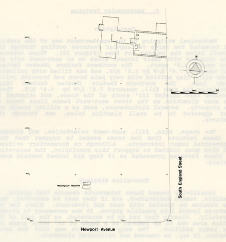 Figure 33. Location of the two rectangular features
When the entire clay fill was removed in this section and no evidence of human remains was found, the southern half of the northern feature was similarly excavated. Upon finding no indication of a burial in the fill of this section, the northern halves of both features were then excavated. Soil samples were taken of all layers within these features.
Southern Feature
During the removal of the southern half of Master Context C02, a small piece of a long bone shaft was discovered at a depth of 0.5' below the top of the hole. Excavation was halted until staff zooarchaeologist Joanne Bowen-Gaynor positively identified the faunal material as a medial section of a long bone shaft from a pig (Sus scrofa). Removal of the yellowish brown silty clay (44B-363 and -364) continued, revealing a hole with straight sides. Numerous machine-made nails were dispersed throughout the silty clay, and their locations were recorded. Other artifacts included English delft, pearlware, and Chinese export porcelain, with a terminus post quem of 1805 provided by the machine-made nails. A piece of wood appeared at a depth of 1.6' below the top of the feature. This wood, a 3.3' x 0.3' fragment of what appeared to be a roughly finished 1.5" board, was set slightly askew on the perimeter of a soil discoloration. This discoloration was located 0.15' from the southern edge of the feature (Figure 34) and extended to the east and west within 0.07' to 0.15' of each end. This stain cut a shelf of relatively clean yellow redeposited clay (44B-480 and 44B-481), which extended to the edges of the rectangular feature. The wood rested on the edge of this clean fill, set into and covered by the yellowish brown silty clay fill. Excavation continued, exposing more wood at greater depths. This wood, composed of thick cut planks, was identified by Marshall White of the Virginia Polytechnic Institute & University as Southern yellow pine (Pinus spp.). It was scattered in disarray throughout the feature with most of it arranged along the edges of the pit filled with yellowish brown silty clay (Figure 35). Machine-made nails were embedded in some of the wood. The stain, within which the wood was contained, by its shape and size (7.6' E/W x 2.7' N/S) appeared to represent an octagonal or hexagonal coffin stain. Although it seemed likely that the wood represented demolished structural remains of some kind, the thickness and unfinished state of the wood did not suggest a coffin. Also supporting this conclusion, there were no bones of any type located within the fill above the wood, with the exception of the pig bone previously mentioned. Below the yellowish brown silty clay fill, in and around the wood, appeared a brownish yellow loamy sand (44B-471 and 44B-472). At this point, deeper excavation was halted and the northern section of silty clay fill was removed to expose still more wood and the same shelf of clean redeposited yellow clay cut by the silty clay
94
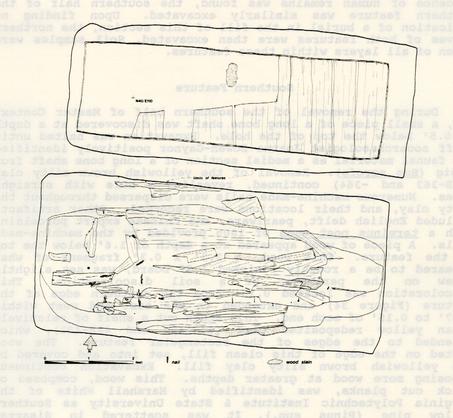 Figure 34. Plan view of northern and southern rectangular features
95
Figure 34. Plan view of northern and southern rectangular features
95
 Figure 35. Disarrayed wood in southern rectangular feature.
96
along the northern edge of the feature. Here also the wood was located along the sides of the clean redeposited yellow clay.
Figure 35. Disarrayed wood in southern rectangular feature.
96
along the northern edge of the feature. Here also the wood was located along the sides of the clean redeposited yellow clay.
When all the silty clay fill was removed, the outlines of the wood-filled pit were fully visible. The loamy sand discovered in and around the wood was thoroughly mixed with the wooden planks, covering some and underlying others. Cutting through the loamy sand and wood at the western edge of the feature was an oval soil stain (44B-470). This turned out to be an intrusive feature, the fill of which was composed of the same silty clay as the layer above it, and its filling presumably dating to the same time as the deposition of the silty clay. The oval hole contained a portion of a non-leaded glass tumbler, which would date its filling, and consequently the silty clay fill, to after 1864.
After the removal of the yellowish brown silty clay in the oval feature, the loamy sand around the wood was removed. This loamy sand was located both around and below the wood, so the wood had to be pedestaled carefully, investigated, and then removed. More wood was discovered sealed beneath the loamy sand layer, suggesting that the feature had remained open and exposed for some time prior to being filled, with consequent siltation around the wood.
Removal of this loamy sand layer and the wood revealed that the bottom of the feature extended to a total depth of 3.3' below the bottom of the parking lot base. Given that the parking lot grading stripped approximately 1' of soil from this area (Poster 1984b), it can be estimated that the original hole would have extended about 4.5' below the original 19th-century ground surface. The clean redeposited yellow clay (44B-480 and 44B-481) located around the perimeter of the feature was removed last, revealing the feature as a straight-sided hole cut into subsoil. Machine-made nails and oyster shell were included in this redeposited subsoil, but unfortunately there were no artifacts with which to provide firmer dating for the construction of this, the original hole.
Northern Feature
As with the southern feature, the northern rectangular stain (Master Context C01) was bisected along an east-west axis, and the southern half removed. This feature contained the same yellowish brown silty clay (44B-428, -429, -439, and -440) which was present in the southern feature. This layer extended to a depth of 1.65' below the bottom of the parking lot base, at which level remnants of wood began to appear. Unlike the disarrayed wood in the other feature, however, this wood formed a rectangular unlidded box measuring 7.0' E/W by 2.4' N/S (Figures 34 and 36). The interior of the box also contained the same
97
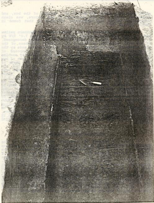 Figure 36. Wooden box in northern feature
98
silty clay fill which had sealed it. Outside of the box, and extending 0.2-0-4' to the perimeter of the feature, was clean redeposited yellow clay apparently identical to that found in Master Context C02.
Figure 36. Wooden box in northern feature
98
silty clay fill which had sealed it. Outside of the box, and extending 0.2-0-4' to the perimeter of the feature, was clean redeposited yellow clay apparently identical to that found in Master Context C02.
The box was composed of ½" thick planks of Southern yellow pine, joined with machine-made nails. It measured 7.0' E/W by 2.4' N/S by 0.9' deep. Although the wood was badly decomposed, it was still possible to discern the original thickness of the side planks of the box through the soil discoloration made by the decomposing wood. The bottom of the box was composed of horizontally running planks, joined to the side planks by machine made nails at 0.3' intervals (Figure 34). The side planks of box were held together with nails spaced 0.2' apart. The layer of redeposited subsoil, evident around the outside of the box, and the construction of the box itself, indicated that it had been built prior to being placed in the slightly larger hole. Clean yellow clay was then packed around the sides, up to within 0.1' to 0.2' of the top of the box. Unfortunately there were no datable artifacts contained within the redeposited yellow clay to help indicate when the box was placed into the ground. The machine-made nails holding the box together, however, indicate that the box must have been built after 1805, when this method of nail-making became common. Artifacts within the yellowish brown silty clay (44B-428, -429, -439, and -440) provided a terminus post quem of 1805 as well for the filling of the feature, also on the basis of machine-made nails. Unlike the southern feature, there was no evidence of silting in this hole, suggesting that it did not remain open and exposed to the elements for a long period of time.
Pit Below Southern Feature
A floor of subsoil was revealed after the last of the disarticulated wood and loamy sand was removed. from the southern feature. A 1.2' by 2.4' discoloration cutting the subsoil in the center of Master Context C02, however, suggested the presence of another feature (Figure 37). The western half of this feature was carefully excavated to determine its characteristics. Excavation revealed a 1.0' deep pit, filled mostly with loamy sand and a few pieces of wood from the feature above. Set into sand and a few pieces of wood from the feature above. Set into this pit, at a depth of 0.7', was a 0.9' by 1.5' wooden box, constructed of 0.5" thick boards joined by machine made nails. The box appeared to have been covered with a wooden lid, which had almost disintegrated on the western side of the box but was fairly intact on the eastern side. Nothing was found inside the western half of the box except brownish yellow loamy sand fill.
99 Figure 37. Plan and profile of small pit in southern feature
Excavation of the eastern half of the pit was then begun. The wooden lid of the box, more intact here, was removed to reveal more of the same brownish yellow loamy sand fill present in the western half. Within this fill, however, were several small flecks of badly disintegrating material. This material was identified as bone by Joanne Bowen-Gaynor (personal communication 1984), but proved to be too fragmentary and decomposed to identify to species. It appeared to be flat bone, possibly part of a skull (Figure 38).
Due to the ambiguous nature of this find, and the improbability of ever positively determining whether it was a human, it was decided simply to treat this feature as if it did indeed represent an infant burial. Since the entire area around the feature was going to be excavated 25' below grade for the underground parking lot, the feature was removed. After a court order was obtained from the City of Williamsburg and James City County Circuit Court, the box and its contents were carefully excavated, place inside a larger box, and reinterred in a small cemetery located to the east of the site (see Appendix 8 for a 7 full description of this reinterment).
Discussion
Excavation did not reveal positive identification of these features, and in this section several explanations of their possible function(s) will be offered. If not a burial, these features may have represented some type of feature related to the gardening or farming activities behind Tazewell Hall.
Grave pits can be of almost any size, but are virtually invariably oriented east-west. Blakely and Beck (1982) uncovered 391 19th-century graves in Oakland Cemetery in Atlanta, finding them all oriented east-west but ranging in size from 2.5' x 1.0' to 8.0' x 3.0'. These dimensions were determined by the size of the coffin, which in turn was determined by the size of the deceased individual.
They found that of the 17 pits that they actually excavated, all dated to after 1850 and were dug with vertical walls to a depth of about 3.5', after which the floor was levelled and a smaller chamber was dug in the exact shape of the coffin. The depth of these smaller chambers ranged from 0.7 to 1.0'. The coffins themselves, mostly decayed, were made in at least three shapes: rectangular, oblong hexagonal, and oblong octagonal (Blakely and Beck 1982:188). The hexagonal coffins were apparently the earliest style, partially replaced by the octagonal coffin and then the rectangular one, first made around 1850 (Blakely and Beck 1982; Kline and Kline n.d.). Members of lower socio-economic groups, however, apparently continued to
101
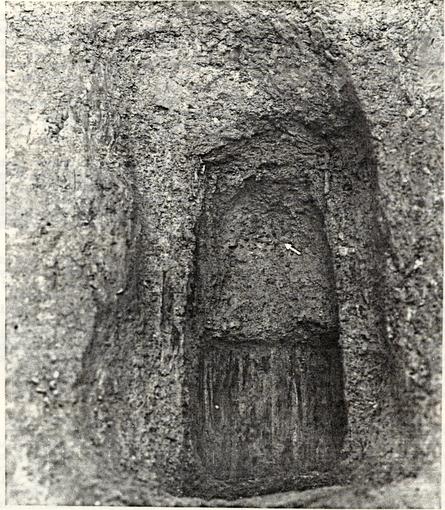 Figure 38. Small box in southern feature
102
utilize octagonal coffins even after the rectangular style became popular with the more wealthy individuals.
Figure 38. Small box in southern feature
102
utilize octagonal coffins even after the rectangular style became popular with the more wealthy individuals.
The pits found at Tazewell Hall superficially resembled the Atlanta grave pits, at least in size, shape, and orientation. Excavation did not necessarily confirm this interpretation, however, since no human bones were recovered in either pit, except (perhaps) for the possible human bone in the small pit in the southern feature. Since the wood in both features was well-preserved, it is highly unlikely that soil conditions would have caused the decomposition of all bone in the upper parts of the two features, although the moisture and soil acidity in the small pit in the southern feature probably contributed to the decomposition of most of this softer, more permeable bone.
An interpretation of the two features as grave pits, therefore, must explain the loss of the most telling evidence, the skeletons themselves, as a result of later disinterment. The presence of the decomposing bone in the small, lidded box in the bottom of the southern pit could then be explained by assuming that this small pit intentionally or unintentionally remained undisturbed when the disinterment took place.
The disinterment in the southern feature must have included removal of the coffin, if one existed. However, the disarrayed wood thrown back into the pit, though obviously once part of a joined structure of some kind (since nails were still embedded in some of the wood), was probably not the remnant of a coffin, however crude that coffin may have been. The planks appear to have been simply tossed into the pit as part of the filling process, perhaps coming from something recently demolished nearby. The shape of the chamber into which these planks were thrown, on the other hand, strongly suggests a hexagonal or octagonal coffin, although this shape may possibly have been an inadvertent result of the way in which the coffin was dug out.
The disinterment in the northern feature must have left in place the larger rectangular wooden box, which probably served as a vault. In this feature the lid of the "coffin", if that it was the actual function of the box, had been removed, but the box left in place. This box, like the disarrayed wood in the other feature, was made' of Southern yellow pine, a wood also traditionally used for less elaborate coffins and for those of lower socio-economic classes (Habenstein and Lamers 1955). This suggests that the deceased in this feature was probably a relatively poor individual, perhaps even a slave. By extension the individual buried in the grave just to the south must have been relatively poor as well, since spatial segregation between rich and poor is a common and pervasive practice in 18th-, 19th-, and even 20th-century grave sites.
103The rectangular box found in the northern feature, if it is a vault, could have held a coffin of any shape. The soil outline in the southern feature, on the other hand, suggests that there was no vault and that a hexagonal or octagonal coffin was probably present.
However, the shortcomings of this explanation are numerous. The "disinterment" holes are unlikely to have been oriented in such a way as to parallel and totally eradicate evidence of the original interment holes, particularly after several years when the outlines of the original graves would begin to be weathered away.
An alternative possibility is that these features represent garden-related features, such as cold frames or compost heaps. Their proximity to the large planting bed may suggest that they were constructed there to serve as starting boxes for plants which were later transferred to the planting bed. The holes would have been covered with a frame constructed of wood and glass, which would enable the warmth of the sun to reach the plants.
It was also suggested that the features may have represented storage pits for root vegetables, such as potatoes and carrots. Root vegetables are usually stored in sand, however (Kelso 1984:117), and there was no sand evident in the fill of either of these features.
Neither of these explanations of these as garden features is totally acceptable either. The depth of the two pits, some 4.5' below the 19th-century ground surface, would have been rather deep for garden remains. A cold frame or some similar device would be expected to leave other traces as well, including postholes for the supports of the covering device, protruding even down into the graded surface beneath the parking lot. Most importantly, perhaps, is the nature of the silty clay fill of both features. This soil has a Ph value of 6.0 and seems an unlikely place for plant growth or decomposition. A more organic soil, like that found in the planting bed (Feature 13), would be expected.
In summary, the two features presented a body of confusing evidence. It was not possible even to relate them to a particular household, since they may have been constructed any time after 1805, though probably in the later 19th century. As the most unusual features on the property, they present a continuing puzzle in reconstructing the history of this lot.
CHAPTER 6
ARTIFACTS
by Ann Morgan Smart and William Pittman
106
FIGURE 39
A. Chamber pot, base through rim. This saltglazed chamber pot is made up of a fine grey paste and is uniformly covered with a lustrous brown engobe. The only ornamentation is a broad mechanically incised band composed of short wavy lines interrupted by pairs of square impressions. The standing ring is simple as is the rolled rim. A single strap handle was applied to the side after the completion of the incised decoration. This type of brown saltglazed stoneware was commonly produced in Nottinghamshire and Staffordshire potteries as early as 1690.
Found in boundary ditch.
Catalog # 213.44B-514 (Vessel # 398).
Principal measurements: 12.2 cm standing rim diameter.
18 cm rim diameter.
12.75 cm height.
Archaeological context: 1762-1778.
B. Chamber pot, base/body fragments. Black-glazed redware. This vessel is composed of a high fired coarse earthenware body dusty brick red in color and is uniformly colored on the interior with a dark brown glaze. The same dark brown glaze partially covers the exterior except for the area nearest the base. The vessel wall curves gradually to a simple rolled base without footring. Black glazed redware was commonly produced throughout the 18th century in English potting centers.
Found in boundary ditch.
Catalog # 154.44B-514 (Vessel 382).
Principal projected measurement: 13.2 cm base diameter.
Archaeological context: 1762-1778.
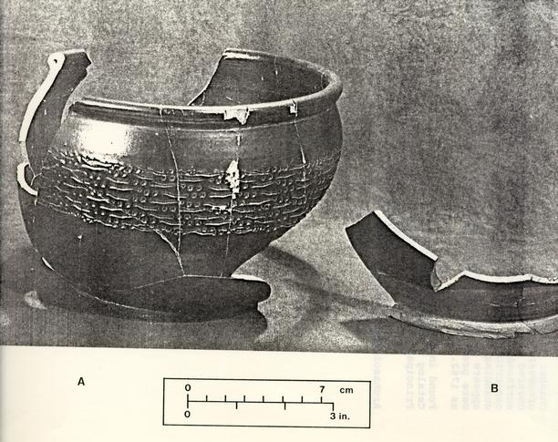 Figure 39. Brown saltglazed and black-glazed redware chamber pots
FIGURE 40
Chamber pot, rim to base fragments. This undecorated creamware vessel has a thin-walled refined earthenware body covered by a clear lead glaze on interior and exterior surfaces. The pear-shaped body curves outward from a slightly constricted mouth and through a full-bellied waist to the standing ring. A single vertical strap handle terminal appears on the assembled fragments. Chamber pots of this ware were produced throughout the English pottery centers as early as 1762.
Found in boundary ditch.
Catalog # 155.44B-515 (Vessel # 392).
Principal measurements: approx. 12.8 cm base diameter.
approx. 20 cm rim diameter.
13.9 cm height.
Archaeological context: 1762-1778.
 Figure 40. Creamware chamber pot
FIGURE 41
A. Bowl; rim and body fragment of annular creamware. Vessel is decorated with annular banding and common cable in blue, brown, tan, and cream. An incised herringbone band below rim is impainted with pale khaki, with a similar khaki band appearing below the cabled band. Clear lead glaze covers the entire surface of the assembled fragment. The body is a thin-walled refined earthenware fabric. Bowls of this type and design were known to have been produced by English potters as early as 1790.
Found in redeposited clay fill of west wing cellar.
Catalog # 020.44B-301 (Vessel # 53).
Principal measurement: approx. 12.4 cm diameter.
Archaeological context: 1835.
B. Bowl, rim/body fragments of annular creamware. Vessel is decorated with annular banding and common cable in brick red, blue, brown, and brown-grey on broad band of brownish-grey flanked by two narrow contiguous dark brown bands. Clear lead glaze covers the entire surface of the fragment. The body is a thin-walled refined earthenware fabric. Bowls of this type and decoration were known to have been produced by English potters as early as 1790.
Found in redeposited clay fill of the west wing cellar.
Catalog # 021.44B-301 (Vessel 56).
Principal measurement: approx. 14.4 cm diameter.
Archaeological context: 1835.
 Figure 41. Annular creamware bowls
FIGURE 42
All fragments depicted are brown transfer printed whiteware of the "Italian Flower Garden" pattern produced by John and William Ridgeway of Staffordshire between 1814-1830.
A. Plate, rim through base fragments. This vessel has a true whiteware body and distinctive scalloped rim with embossed flowers. The molded shape is accented by the transfer printed pattern of sharply serrated dark brown lines and a similarly scalloped light brown stippled field. Beneath this is a rococo border of scallops interspersed with a floral motif on the vessel's marley. The central pattern is outlined by delicate brown lines and the extant portion on these fragments illustrates a stylized fountain and flowering prunus. Underglazed brown printing and stippling were introduced in 1810, but the ware type did not begin production until around 1820.
Found in Knight backfill of west wing cellar.
Catalog # 093.44B-291 (Vessel # 172).
Archaeological context: 1948.
B . Platter, rim fragment. This transfer printed brown whiteware serving vessel is represented by one rim to marley fragment decorated with serrated edge, scroll and floral motif.
Found in redeposited clay fill of west wing cellar.
Catalog # 095.44B-119 (Vessel # 179).
Archaeological context: 1835.
C. Plate, base fragment. This portion of the central romantic motif is the same as shown in (A) by the stylized fountain and prunus and thus represents a second unique vessel of the same set on the bottom of this fragment is found the very corner of the pattern mark.
Found in Knight backfill of west wing cellar.
Catalog # 094.44B-220 (Vessel # 323).
Archaeological context: 1948.
D. Platter, base fragment. The interior of the fragment depicts a stylized structure with foliage and palm-like trees behind a lake with mountains in the distance. As shown here, a large portion of the maker's mark and pattern name is printed on the bottom, in italic script "Italian Flower Gardens" with "JWR" beneath it, all in an oval of scrolled edges and flowers.
Found in Knight backfill of west wing cellar.
Catalog # 095.44B-292 (Vessel # 179).
Archaeological context: 1948.
 Figure 42. Matched transfer printed whiteware
FIGURE 43
Can, rim through base fragments. This cylindrical drinking vessel is made of a refined whiteware paste with a clear lead glaze covering the entire piece. A single vertical handle with foliate terminals is applied to the side of the vessel opposite a brown transfer printed scene above the caption "FOR A GOOD GI(RL?)" in Roman block letters. The majority of the scene is not present; however, a small cat-like animal is visible in the lower left foreground. No maker's marks are evident on these assembled fragments. Vessels of this type printed with special scenes, motifs, and messages were often presented as gifts in the last three quarters of the 19th century, while the ware type does not precede 1820.
Found in redeposited clay fill of west wing cellar.
Catalog # 099.44B-163 (Vessel 194).
Principal measurements: 6.0 cm base diameter.
6.2 cm height.
Archaeological context: 1835.
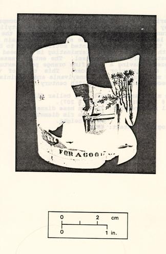 Figure 43. Whiteware can
FIGURE 44
This American grey stoneware storage jar is comprised of a fine grey paste upon which has been painted stylized floral motif s running laterally around the vessel at the height of the two lateral handles on the shoulder and again around the waist of the vessel. The painted motifs appear to be straight stems with graduated petals terminating in a closed tulip-like bud repeating around the vessel. The entire vessel has been salt glazed, leaving a very fine orange peel texture on both interior and exterior surfaces. This type of vessel was produced most commonly in Pennsylvania and Virginia and dates to the second quarter of the 19th century.
Found in mixed area of west wing cellar fill.
Catalog # 200.44B-130 (Vessel # 207).
Principal measurements: 22.5 cm base diameter.
22.1 cm rim diameter.
35 cm height.
Archaeological context: 1835.
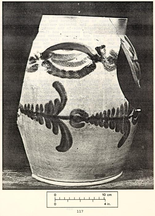 Figure 44. American grey stoneware storage jar
FIGURE 45
A. Flower pot. This unglazed earthenware pot is composed of a coarse pale orange to buff colored body with small dark red brick-like inclusions. The interior surface exhibits potting rings and one large drain hole in the center of the base. The exterior surface has been smoothed and flairs gradually from the base to a raised and incised cordon beneath the flaired and rounded rim. One broad incised line appears approximately two-thirds the way up the side of the vessel. Similar unglazed flower pots have been excavated at many sites.
Found in rubble fill of west wing cellar.
Catalog # 201.44B-153/303/159 (Vessel # 20).
Principal projected measurements: 20.8 cm base diameter.
38 cm rim diameter.
29.4 cm height.
Archaeological context: 1835.
B. Flower pot. This unglazed flower pot is comprised of a coarse dusty-orange body with dark red brick-like inclusions. The interior exhibits potting rings while the exterior has been smoothed and has a slightly darker orange color. The vessel flairs gradually from the base to raised and incised cordon and a broad incised line can be seen approximately two-thirds the way up the side of the vessel.
Found in mixed area of west wing cellar fill.
Catalog # 202.44B-153 (Vessel # 121).
Principal measurement: 20.5 cm base diameter.
Archaeological context: 1835.
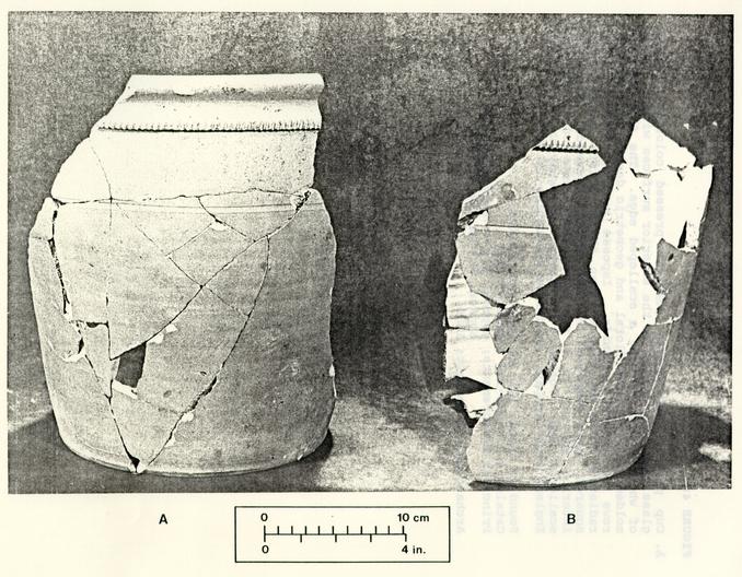 Figure 45. Earthenware flower pots
FIGURE 46
A. Cup plate. This nearly complete pressed colorless leaded glass vessel is molded on the exterior surfaces with a "sheaf of wheat" motif forming a scalloped edge. The flat base is molded with a raised floral and geometric design comprised of rows of faceted pyramids. Imposed between floral leaves radiating from the central open flower motif, appear small squares, each comprised of four faceted pyramids. The only interior molding is a series of small dots outlining the scalloped edge. Possibly attributed to Sandwich and/or New England Glass Company, beginning production in 1825.
Found in rubble fill of west wing cellar.
Catalog # 114.44B-313 (Vessel # 325).
Principal measurements: approx. 6.8 cm base diameter.
approx. 9.2 cm rim diameter.
Archaeological context: 1835.
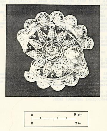 Figure 46. Pressed glass cup plate
FIGURE 47
A. Wine bottle, rim, body and base fragments. This French wine bottle is of thin straw green metal, exhibiting some surface deterioration. The finish of the bottle consists of an uneven lip and a flattened string rim of varying width. The basal kick is domed with a distinct pontil scar. The shoulder of the body bears a vintner's seal consisting of a single application of glass into which a circular seal has been impressed. The seal consists of the words "Chateau Margaux" surrounding a vine with leaves and a cluster of grapes, superimposed upon a horizontally linear background.
Found in rubble fill of west wing cellar.
Catalog # 203.44B-303 (Vessel # 284)
Archaeological context: 1835.
B. Same as (A).
Found in rubble fill of west wing cellar.
Catalog # 204.44B-303 (Vessel # 283).
Archaeological context: 1835.
C. Detail of vintner's seal on French wine bottle described in Figure 47B. The seal consists of the words "Chateau Margaux" surrounding a vine with leaves and a cluster of grapes, superimposed upon a horizontally linear background.
Found in rubble fill of west wing cellar.
Catalog # 131.44B-303 (Vessel 283).
Archaeological context: 1835.
 Figure 47. Chateau Margaux wine bottles
FIGURE 48
A. Hearthstone (?). These fragments of fossiliferous limestone are believed to be part of a hearthstone. The stones vary in color from a slate gray to a pale dusty gray and exhibit a high percentage of fossiliferous inclusions, which are white in color. A shallow channel has been cut and smoothed running parallel to the finished edges but not equidistant from them. Considerable surface deterioration is evident due either to abrasive wear or heat.
Found in rubble fill of west wing cellar.
Catalog # 217.44B-130 (Object # 341).
Principal measurements: 22.5 cm width.
2.1 to 3.3 cm thickness.
3 cm channel width. Archaeological context: 1835.
B. Detail of hearthstone (?). These fragments are of the same material described above. These fragments differ from those previously discussed in thickness and are slightly curvilinear on one finished edge. The accompanying cut and smoothed channel follows this curving edge. As shown in this detail photograph, a hand written inscription appears on one edge, most likely carved on two separate occasions due to the difference in lettering. The inscription reads: "D. [block letter] W [block letter] ILKINS (cursive letters]". The identity of this D. Wilkins has not been established.
Found in rubble fill of west wing cellar.
Catalog # 217.44B-130 (Object # 340).
Principal measurement: 4.5 cm thickness.
Archaeological context: 1835.
 Figure 48. Hearthstone (?)
FIGURE 49
A. Tobacco pipe, bowl fragment. This pipe of fired earthenware has an exterior surf ace covered with lead glaze of a dark brown color. The interior of the bowl does not appear to have been intentionally glazed, even though some glazing appears. It is in the shape of a stylized Indian head complete with facial features and feather headdress. A renewable length of hollow reed was inserted into the base of this bowl. This type of inexpensive tobacco pipe became common around 1800 and were popularly known as "penny pipes". Pipes of this type supplanted the use of white kaolin pipes of British, and particularly Bristol, manufacturing popular during the previous two centuries.
Found in rubble fill of west wing cellar.
Catalog #126.44B-303.
Principal measurements: 0.6 to 0.7 mm reed aperture diameter.
1.6 cm breadth of bowl at base (through molded "face").
4.0 cm approximate length of base from reed aperture to bowl base.
Archaeological context: 1835.
B. Tobacco pipe, bowl fragment. This pipe is the same type as that described above. Its earthenware paste, however, is pinkish-tan, and it has a clear lead glaze.
Found in rubble fill of west wing cellar
Catalog # 125.44B-303.
Principal measurements: 0.8 cm reed aperture diameter.
1.8 cm bowl aperture diameter.
2.2 cm breadth of bowl at base (through molded "face").
3.5 = length of bowl from reed aperture to bowl base.
3.7 cm depth of bowl.
Archaeological context: 1835.
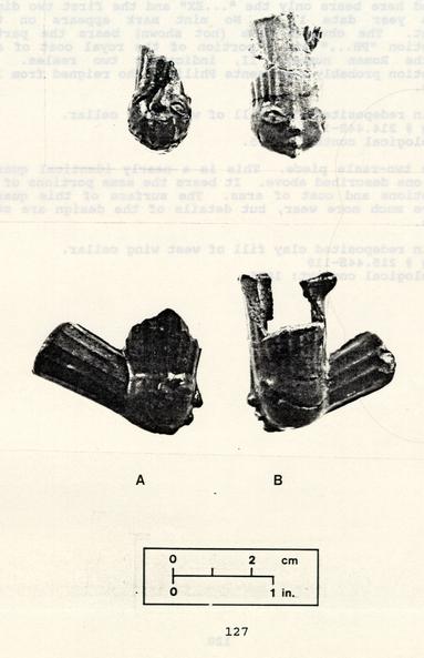 Figure 49. Stylized two-reale pieces
FIGURE 50
A. Spanish two-reale piece. This quartered silver coin was originally from a Spanish two-reale piece whose reverse side bears the arms of Spain and the complete inscription "HISPANIARUM REX", followed by a year date. The quarter pictured here bears only the " ... EX" and the first two digits of the year date 17__ . No mint mark appears on this fragment. The obverse—side (not shown) bears the partial inscription* "PH... " and a portion of the royal coat of arms with the Roman numeral II, indicating two reales. The inscription probably represents Philip V who reigned from 1700 to 1749.
Found in redeposited clay fill of west wing cellar.
Catalog # 214.44B-119.
Archaeological context: 1835.
B. Spanish two-reale piece. This is a nearly identical quarter to the one described above. It bears the same portions of the inscriptions and coat of arms. The surface of this quarter displays much more wear, but details of the design are still legible.
Found in redeposited clay fill of west wing cellar.
Catalog # 215.44B-119
Archaeological context: 1835.
 Figure 50. Spanish two-reale pieces
FIGURE 51
Suspension eye and chains for hall lantern. This copper alloy apparatus was used to suspend a glass globe in which a candle was placed. These globes were often highly decorated and of French or English manufacture. They date from the late eighteenth to the early nineteenth century.
Found in redeposited clay fill of west wing cellar.
Catalog # 140.44B-335.
Principal measurements: 8.5 mm height of "finial".
4.4 mm diameter of bottom ring.
14.2 mm chain length.
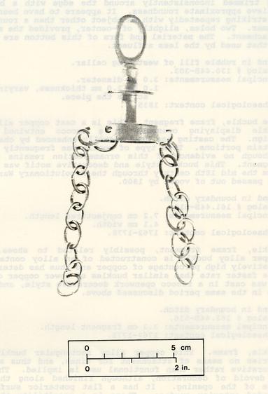 Figure 51. Suspension device for hall lantern
FIGURE 52
A. Button, one-piece. This soft lead alloy button was possibly formed from a spherical lead projectile hammered into a disc and trimmed inconsistently around the edge with a blade to achieve approximate roundness. It appears to have been formed by striking repeatedly with an object other than a round-faced hammer. Two holes, slightly off-center, provided the means of attachment. The material and form of this button are similar to that used by the less affluent.
Found in rubble fill of west wing cellar.
Catalog # 130.44B-303.
Principal measurements: 3.0 cm diameter.
1.0 to 2.0 mm thickness, varying across the piece.
Archaeological context: 1835.
B. Shoe buckle, frame fragment. This is a cast copper alloy shoe buckle displaying openwork in a rococo entwined floral design. The casting has been visually enhanced by chasing on certain portions. This type of buckle was frequently gilded, although no evidence of this ornamentation remains on this fragment. This buckle style and decorative motif was popular from the mid 18th century through the Revolutionary War period and passed out,of vogue by 1800.
Found in boundary ditch.
Catalog # 161.44B-514.
Principal measurements: 7.2 cm conjectured length.
4.1 cm width.
Archaeological context: 1762-1778.
C. Buckle, frame fragment, possibly related to shoes. This copper alloy buckle is constructed of an alloy containing a relatively high percentage of copper and thus has deteriorated at a faster rate than similar buckles of lower copper content. It was cast in a rococo openwork decorative style, and was in use in the same period discussed above.
Found in boundary ditch.
Catalog # 162.44B-516.
Principal measurements: 3.3 cm fragment length.
Archaeological context: 1762-1778.
D. Buckle, frame. This copper alloy rectangular buckle frame carries no means of attachment for tines,. and thus a purely decorative rather than functional use is implied. The frame is devoid of decoration, although finished along the inner edge of the opening. It has a flat posterior surface and rounded anterior surface. There is a possibility that this 133 frame was unfinished due to a minor casting flaw evident on the anterior surface.
Found in plowzone.
Catalog # 138.44B-492.
Principal measurements: 2.9 cm length.
1.9 cm width.
2.1 cm x 1.1 cm interior opening.
Archaeological context: undated.
E. Buckle, corner fragment. This copper alloy fragment may, have been a part of a simple openwork shoe buckle. There is no apparent decoration on the extant portion.
Found in charcoal lens in fill of west wing cellar.
Catalog # 137.44B-195.
Principal measurement: 12.6 mm fragment length.
Archaeological context: 1835.
 Figure 52. Buttons and buckles
FIGURE 53
A. Button, one-piece. This copper alloy button is of the type commonly used on outer garments, particularly of male attire. It is round, with impressed stars circling the edge. The central motif is a circle of radiating arrow heads joined with a series of crescent shaped lines composed of small impressed dots. This button was originally heavily gilded, remnants of which can be seen in all of the impressed designs. A single soldered loop on the back forms the only means of attachment.
Found in Knight backfill of main house.
Catalog # 133.44B-106.
Principal measurements: approx. 2.75 cm diameter.
1 mm thickness at rim.
Archaeological context: 1948.
B. Button, one-piece. This copper alloy button is of the same type described above. It is round with a highly stylized floral pattern engraved on the flat anterior surface. This floral engraving surrounds three centrally positioned concentric circles. All of the engraved decoration appears to have been mechanically applied. The back of the button is slightly concave and bears one single wire loop.
Found in spoil.
Catalog # 135.44B-125.
Principal measurements: 2.7 cm diameter.
2.0 mm thickness at rim.
Archaeological context: Undated.
C. Button, one-piece. Made of copper alloy, this flat small clothes button has no apparent surface decoration aside from a small quantity of gold gilding on the anterior surface. The back of the button is equally flat but is stamped "B & BURNHAM, best.d.gilt.11 A single soldered loop forms the means of attachment.
Found in Knight backfill of main house.
Catalog # 134.44B-102.
Principal measurements: 1.7 cm diameter.
1.5 cm thickness at rim.
Archaeological context: 1948.
D. Button, one-piece. This copper alloy small clothes button has a flat plain surface that may have been gilded, but has no remaining surface decoration. The rear of the button has a circular impressed design comprised of a series of stylized leaves within a broad band. The means of attachment was a single soldered loop.
137Found in posthole.
Catalog # 132.44B-230
Principal measurements: 1.5 cm diameter.
0.5 mm thickness at rim.
Archaeological context: Post-1805.
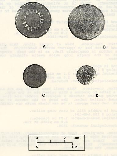 Figure 53. Buttons
FIGURE 54
A. Button, one-piece. This copper alloy button has a slightly convex face and no engraved ornamentation. The posterior surface is slightly concave with an iron wire loop attachment. There is no evidence of gilding or any other applied or incised ornamentation. The size of the button would suggest use on outer garments, as compared to that used on small clothes.
Found in northern rectangular feature.
Catalog W 131.44B-428.
Principal measurements: 2.6 cm diameter.
1.0 mm thickness at rim.
Archaeological context: Post-1805.
B. Button, one-piece. Made of copper alloy, this plain flat round button has no apparent surface decoration. The face of the button is completely flat, as is the back, except in the area of the single loop which swells slightly toward the center.
Found in spoil.
Catalog W 136.44B-503.
Principal measurement: 2.2 cm diameter.
1.0 mm width at rim.
Archaeological context: Undated.
C. Button, one-piece. this small bone button was cut and turned on a lathe to produce a thin raised rim at the edge. It has a curving surface towards a depressed center and five unevenly spaced drilled holes. The back of the button is completely flat, but what appear to be saw blade marks are visible.
Found in rubble fill of west wing cellar.
Catalog # 128.44B-194.
Principal measurements: 1.75 cm diameter.
2.0 mm-width at rim.
Archaeological context: 1835.
D. Button, one-piece. Made of mother-of-pearl, this button has a chamfered edge on the front and is completely flat on the back side. There are four unevenly spaced holes which provide attachment. This type of button was commonly used on shirts, blouses, and undergarments.
Found in rubble fill of west wing cellar.
Catalog # 129.44B-159.
Principal measurements: 1.1 cm diameter.
2.0 mm width at rim.
 Figure 54. Buttons
CHAPTER 7
CONCLUSION
As originally conceived, the Tazewell Hall project was intended to reveal details of the life and material remains of John Randolph's household. It developed, of necessity, into something entirely different: an investigation of the sometimes shadowy traces of garden and landscape features, a study of a group of terminal deposits associated with ownership changes, and evidence of the varying status of its different occupants over time.
Only recently have gardens received a great deal of attention from historical archaeologists. Archaeological investigations around large plantation houses at Carter's Grove, Kingsmill, and Monticello has shown the potential for interpretation of fencing, terracing, orchard and vineyard location and garden patterns (Kelso 1984b). Even on more disturbed urban sites in Williamsburg, archaeology has shown the locations of fences, walls, walkways, terraces and other features (A. Noël Hume 1974).
Tazewell Hall had an extensive formal garden in the 18th century. This is clear from the Desandrouins Map (1781), which shows a large enclosed garden behind the house, composed of two discrete rectangular sections of plantings and two smaller blocks which may represent either outbuildings or planting beds. As depicted on the map, the complex is oriented to reduplicate the dimensions of the house in two similar and parallel units, bordered on all sides by what are probably walkways. The detail of the interior of each garden unit is not easily discernible, although the northern one contains what may be a depiction of a set of perpendicular walkways dividing it into four roughly equal sub-units.
It is almost certain that the originator of this garden was John Randolph, whose interest in gardening led him to write a manual for his friends and neighbors (Warner 1924). Randolph's "Treatise" is devoted exclusively to the kitchen garden, i.e. the cultivation of edible vegetables. Although he relied heavily on Philip Miller's The Gardener's Dictionary, published in England in 1754, his alterations to suit Virginia's climate suggest that Randolph, did considerable personal experimentation in his own garden. The "Treatise" does not discuss the cultivation of purely ornamental flowering plants and shrubs, but one must assume that Randolph had these in his garden as well.
It is unfortunate that little remained of the occupation levels associated with Randolph's tenure. Almost without 144 exception his planting seems to have been relatively shallow and the evidence thus obliterated by subsequent plowing and grading. The planting bed found in the southwestern corner of the project area revealed little dating evidence, but from all indications appears to be associated with Randolph. However, no seeds or other remains could be obtained to determine what was being grown. A few other trenches and tree holes may date to this period, but no sort of pattern could be discerned from such scanty evidence.
Whatever its exact configuration, Randolph's garden was probably maintained by the next occupant, John Tazewell. Whether Tazewell or his son Littleton had any great interest in gardening is not known, but by the early 19th century, Littleton had considerably altered the garden bounds. An east-west fence line 1451 south of the house probably formed a division between the much reduced formal garden and some sort of back lot pasturage. An alteration in the garden's configuration might also be expected, but the lack of good dating control makes this almost impossible to determine. It is perhaps worth noting that most of the garden trenches and tree holes south of the house probably date from the early to mid 19th century, indicating deeper cultivation and/or more substantial planting during this period.
Aside from garden remains, the two most important features on the site were the filled west wing cellar and the western boundary ditch. Based on characteristics of the fill and documentary evidence, both represent a special type of archaeological context which may be called a terminal deposit. These are closely related to abandonment processes described on prehistoric sites (e.g., Deal 1985), the major difference being that the abandoned historic urban site is usually reoccupied more rapidly.
The material possessions that are reflected in the two terminal deposits share an important characteristic: they may not faithfully represent the entire range of normally deposited household goods. Because terminal deposits relate to a specific action— i.e. change of occupancy and physical replacement of one household with another— they must be analyzed with reference to the specific corollary actions involved in the moving process.
While most of the family's most valuable possessions would probably accompany them, several factors influence which ones remain behind. Deal (1985:270) suggests that these variables include (1) their portability, (2) the means of transportation (3) the distance to the new site (4) the season of movement, and (5) the relative functional utility of the items. They would apply, albeit differentially, under both gradual and rapid abandonment conditions.
145In any case, the terminal deposit would probably be filled with those items, mostly utilitarian, whose value in real or emotional terms was less than the cost to transport them to a new location. Although inevitably some more valued pieces will be abandoned or broken during the moving process, the overall picture will be one that, if analyzed uncritically, reflects an unrealistic dependence on inexpensive or bulky goods and a relative lack of expensive luxury goods. Certainly in no case will the entire picture of a dynamic, living household be preserved.
The boundary ditch appears to have been filled after Randolph departed for England in 1775, probably as part of a general yard cleaning associated with readying the property for sale or preparing it for John Tazewell's occupancy. The northern part of the ditch, the area closest to the house and its activities, was composed of a dark brown sandy loam that superficially resembled occupation levels from other domestic sites in Williamsburg. Several almost totally reconstructable chamber pots, a large number of glass wine bottle bases and necks, and a number of other ceramics, glass and animal bones were found in this fill.
Months before leaving for England, John Randolph had drawn up an indenture for his brother Peyton Randolph, John Blair, and James Cocke to sell his real and personal estate after his departure, despite his assurance that he only intended to be gone a few months. Certainly he had enough time and foreknowledge to gather a few of his most treasured possessions for shipment. Additionally, after his departure his executors would have been able to maintain his other fine possessions for sale, either together with or separate from his real property. It seems likely that the ditch fill was composed only of the previously broken vessels swept up during yard cleaning and the mostly unpretentious chamber pots and bottles deemed unworthy of inclusion in Randolph's marketable personal property.
Table 2 lists the identifiable ceramic vessels found in the boundary ditch. While this assemblage seems to represent a variety of activities, closer inspection reveals some interesting trends. Tablewares and teawares are mostly represented by small non-mending fragments likely to have been generated from swept-up yard scatter. Among vessels composed of ten or more fragments, only one porcelain overglaze floral plate and one edged creamware plate were likely to have been relatively valued pieces. Two creamware chamber pots (11 and 216 fragments), a Staffordshire brown stoneware chamber pot (30 fragments), a black-glazed redware chamber pot (22 fragments), and a delft drug jar (37 fragments) were the five remaining vessels. Together these account for 316 of the 433 sherds identifiable to vessel. But surely this preponderance of utilitarian ware sherds does not accurately reflect the living Randolph household in its entirety; 146
| U.V.# | Description | # of Fragments |
|---|---|---|
| 375 | Delft ointment pot | 3 |
| 376 | Delft ointment pot | 5 |
| 377 | Delft salve pot | 2 |
| 378 | Delft drug (syrup) jar | 37 |
| 379 | Coarseware butter pot | 8 |
| 380 | Buckley coarseware bowl | 3 |
| 381 | Black-glazed redware bowl | 5 |
| 382 | Black-glazed redware chamber pot | 22 |
| 383 | Creamware plate | 3 |
| 384 | Creamware plate, feather edge | 1 |
| 385 | Creamware plate, dot and diamond | 12 |
| 386 | Creamware platter | 3 |
| 387 | Creamware saucer, beaded trombler | 2 |
| 388 | Creamware saucer | 2 |
| 389 | Creamware cup | 2 |
| 390 | Creamware pitcher | 7 |
| 391 | Creamware chamber pot | 11 |
| 392 | Creamware chamber pot | 216 |
| 393 | Westerwald chamber pot | 4 |
| 394 | Westerwald chamber pot | 2 |
| 395 | Fulham-type stoneware storage jar (?) | 9 |
| 396 | Fulham-type stoneware storage jar | 5 |
| 397 | Fulham-type stoneware storage jar | 3 |
| 398 | Staffordshire brown stoneware chamber pot | 30 |
| 399 | White saltglazed stoneware plate, barley pattern | 4 |
| 400 | White saltglazed stoneware plate | 1 |
| 401 | White saltglazed stoneware plate, lattice pattern | 2 |
| 402 | White saltglazed stoneware plate/platter | 5 |
| 403 | White saltglazed stoneware platter | 1 |
| 404 | White saltglazed stoneware tankard | 2 |
| 405 | Chinese export porcelain plate, underglaze blue | 4 |
| 406 | Chinese export porcelain small plate overglaze floral | 14 |
| 407 | Chinese export porcelain bowl | 3 |
| TOTAL | 433 |
The assemblage associated with the filling of the west wing cellar was apparently much different. The cellar was almost certainly filled in 1835, when Dickie Galt acquired the property and removed the wings as part of a general structural renovation. The fill of the cellar hole consisted of alternating lenses of rubble, orange clay and brownish loam. The orange clay and brown loam were taken from elsewhere on the property to help fill the hole, thus containing items first deposited in an entirely different context. The rubble and its associated items, however, have been interpreted as the results of the primary construction and/or destruction activities involving the removal of the superstructure.
If the assemblage associated with the rubble is thought of as a terminal deposit, similar in origin to the boundary ditch fill, then some obvious problems immediately arise. The contents of the assemblage ranged from porcelain and fine earthenware tablewares and teawares, chandelier parts, and French bordeaux wine bottles to coarse earthenware chamber pots and stoneware bottles. While utilitarian wares were definitely present in quantity, much higher valued items were also dumped into the cellar hole. The questions then become: Why were these objects not transported to their owner's new home, and what does this say about the relationship of the owner/occupant to his or her material possessions? To understand this problem, it is necessary to look at the dynamics of the assemblage itself, the mechanics of acquisition, use and discard, and the history of the property prior to its sale and renovation in 1835.
Many of the ceramic tablewares from the primary rubble fill of the cellar were types commonly used in the 1820s and early 1830s (see Table 3). Viewed as a whole, however, the ceramic assemblage from the rubble fill includes a wide range of tablewares commonly believed to have been in use at different times. Included were feather edged creamwares common in the 1770s, as well as embossed shell edged pearlwares and whitewares. Shell-edge decoration was popular from 1790 to around 1850 and when combined with the edged cream wares from the assemblage, it is seen that this group of ceramic tablewares were in production for more than half a century. Yet it appears that all of these ceramics were discarded in 1835 either by a just departed occupant or from an already abandoned house. If it can be assumed that the ceramics were in use up until the abandonment in 1835, then this presents an excellent opportunity to study the problem of time lag in archaeological assemblages.
Time lag studies in archaeology have been used to determine the span of time between the manufacture and sale of an item and its subsequent discard. A study of late 19th-early 20th century 148
| U.V. # | Description | Date Range |
|---|---|---|
| 28 | Black-glazed redware chamber pot | 1700-1850 |
| 39 | Creamware plate, undecorated | 1790-1830 |
| 40 | Creamware plate, feather edge | 1762-1780 |
| 45 | Creamware plate, royal rim | 1770-1825 |
| 48 | Creamware plate, dot and diamond | 1763-1780 |
| 49 | Creamware tea bowl, undecorated | 1763-1820 |
| 53 | Creamware bowl, common cable | 1795-1830 |
| 55 | Creamware basin, shell edge, embossed edge | 1820-1830 |
| 56 | Creamware bowl, common cable | 1795-1825 |
| 68 | Pearlware plate, shell edge, even scalloped rim | 1800-1832 |
| 80 | Pearlware plate, shell edge, even scalloped rim | 1800-1832 |
| 81 | Pearlware plate, shell edge, even scalloped rim | 1800-1832 |
| 87 | Pearlware soup plate, shell edge, embossed edge | 1822-1835 |
| 88 | Pearlware plate, shell edge, embossed edge | 1822-1835 |
| 92 | Pearlware plate, shell edge, embossed edge | 1822-1835 |
| 102 | Pearlware plate, shell edge embossed edge | 1822-1835 |
| 104 | Pearlware plate, shell edge, embossed edge | 1822-1835 |
| 116 | Pearlware dish, shell edge | 1780-1830 |
| 118 | Pearlware dish, shell edge, unscalloped edge, impressed | 1809-1831 |
| 121 | Pearl/whiteware dish, shell edge, embossed edge | 1822-1835 |
| 128 | Pearlware deep saucer, hand painted | 1790-1830 |
| 149 | Pearlware mug, hand painted polychrome | 1790-1830 |
| 157 | Pearlware mug, hand painted polychrome | 1795-1830 |
| 158 | Pearlware mug | 1790-1830 |
| 172 | Whiteware plate, transfer print, Italian Flower Garden pattern | 1825-1830 |
| 179 | Whiteware dish, transfer print, Italian Flower Garden pattern | 1825-1830 |
| 184 | Whiteware, deep saucer, transfer print, Swiss pattern | 1825-1835 |
| 195 | Pearl/whiteware mug, annular | 1795-1830 |
| 196 | Whiteware ewer, transfer print | 1825-1835 |
| 197 | Pearl/whiteware tray or box, transfer print | 1825-1840 |
| 149 | ||
| 202 | Fulham-type stoneware ointment pot | 1690-1775 |
| 209 | American blue & grey stoneware bottle, painted | 1775-1860 |
| 229 | Chinese porcelain plate | 1700-1830 |
| 232 | Chinese porcelain plate, underglaze blue | 1700-1820 |
| 253 | Chinese porcelain plate, overglaze enamel | 1700-1830 |
| 277 | Bone china bowl, bat printed | 1810-1900 |
| 279 | Porcellaneous scalloped plate | 1820-1835 |
Adams and Gaw used both ceramics and glass from the Silcott assemblages, with glass providing a control date for comparison with the ceramics. During the time period represented by the Silcott sites (late 19th-early 20th century) , the glass industry was advancing at a phenomenal rate, with glass technology rapidly changing. Dating controls on glass for this period were often more -precise than those provided by ceramics, and bottles were used and discarded at a much faster rate than ceramic tablewares (Hill 1982). The Tazewell cellar fill, however, dated to the first quarter of the 19th century, before the glass industry had begun to make the advances that would allow close dating control on glass containers. All of the bottle glass from the cellar fill was free blown and thus difficult to date with accuracy. For this reason, the glass from the cellar fill was not included in this study. Instead the known date of the cellar fill was used as a control for (comparison with the ceramic assemblage.
Maker's marks were used by Adams and Gaw to provide dates for their ceramics, with the average mark in use for just over seventeen years. Since only one ceramic vessel within the primary cellar fill was marked, manufacture ranges were used, with vessel attributes such as color and decorative technique for certain ceramic types refining long manufacture ranges. A chronology developed by George Miller for edged wares provided tight dating control for many of the vessels contained within the assemblage, producing a date span of as little as ten to twelve years for some vessels (Miller n.d.; see Table 3). For examples, Figure 55 shows the variety of shell edged wares located in the 150 rubble fill of the cellar. Based on Miller's chronology of mean date ranges for the different types of edged wares, this sample spans a period of fifty-five years. Vessels A-C have scalloped rims with impressed curved lines, a type with mean beginning and end dates of 1802-1832 (Miller n.d.). Vessel D, with impressed straight lines, has a date range of 1809 through 1831. Vessel E, an embossed creamware, was probably produced between 1820 and 1830, and vessels F-J, with embossed patterns, were most popular between 1822 and 1835.
Thirty-seven identifiable ceramic vessels were located within the primary cellar fill. Initial, mean, and terminal manufacture dates were determined for each vessel. Calculating an average of the initial and terminal dates for these vessels provides a date range of 1784 to 1829.7 for the assemblage, with an average mean date of 1804.6. Thus a difference of 30.4 years elapsed between the mean date of the ceramic vessels' manufacture spans and the actual date of the deposit, a time lag approximately 8 years longer than that found by Adams and Gaw for Silcott.
This longer time period may be explained by several factors. Using the periods of manufacture of ceramics rather than maker's marks provided a somewhat longer date span for some of the ceramics, as much as 130 years in certain cases. Adams and Gaw found that the average mark of the Silcott assemblage was in use for a little over seventeen years, while the average manufacturer's span for the ceramic vessels in the Tazewell assemblage was 45.4 years. Removing the types of ceramic vessels which were manufactured for more than sixty years (i.e. porcelains and coarsewares) provides a date range of 1802.1 to 77 1822.2, with an average mean date of 1815.5. This gives a time lag of 19.5 years, a calculation more consistent with that found by Adams and Gaw.
Another explanation for the initial discrepancy in time lag lies in the difference in the controls used in the two studies. While Adams and Gaw postulated that the use span of glass would be shorter than that for ceramics, they did not actually determine the time lag of bottle deposition. A subsequent study using the Silcott bottles as one of four test cases showed that between six and sixteen years elapsed between manufacture and deposition, depending on what type of container was represented (Hill 1982). The lag for bottles was generally shown to decrease over time, as the amount of time required for manufacturing, bottling, and transportation decreased, along with the lowering cost of glass (Hill 1982). Although the time lag for the Tazewell cellar glass was not calculated due to the difficulty of assigning accurate dates, the ceramic dating does fall in line with the results seen in the Silcott analysis. Removing the few ceramic vessels which had long manufacture spans, which would
151
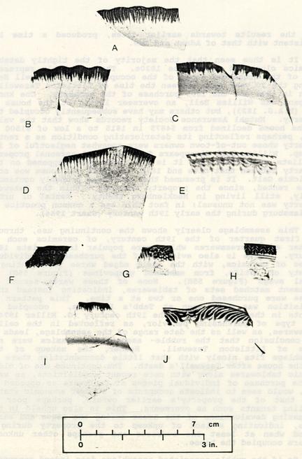 Figure 55. Shell edged wares from the cellar rubble fill.
152
skew the results towards earlier dates, produced a time lag consistent with that of Adams and Gaw.
Figure 55. Shell edged wares from the cellar rubble fill.
152
skew the results towards earlier dates, produced a time lag consistent with that of Adams and Gaw.
It is thus seen that the majority of the tightly datable ceramics clustered around the 1820s. These probably represent some of the household goods of the occupant(s) of Tazewell Hall during the 20 year span between the time of Littleton Tazewell's death in 1815 and the 1835 purchase of the property. one known occupant was William Ball, an overseer living at the house in 1823 (M.A.S. 1823), but others may have subsequently occupied the property. Mutual Assurance Society records show that the value of the house declined from $4875 in 1815 to a low of $1500 in 1830, perhaps reflecting its deteriorating condition as a rental property whose out-of-town owners were somewhat neglectful of its upkeep. William Ball disappears from the local personal property tax lists after 1824, and it is not known what happened on the property between that date and 1835, the year the house was sold to Dickie Galt. It is presumed that the house probably continued to be rented, since the property remained within the Tazewell family, still living in Mecklenburg County. Rental of urban property was not unusual; in fact this was a common practice in Williamsburg during the early 19th century (Smart 1986).
This assemblage clearly shows the continuing use, through the first quarter of the 19th century, of ceramics such as feather edged creamwares which were popular in the late 18th century. There is also evidence of the purchase of individual pieces of ceramics, with the shell edged wares representing a variety of motifs, from embossed grapevines (Figure 55G) to floral swags (Figure 55H). None of these wares seemed to represent matched sets of tablewares, indicating instead that plates were purchased one or two at a time. This pattern of acquisition was also seen at Tabb's Purchase, occupied by tenants in the first half of the 19th century (G. Miller 1974). This type of purchasing behavior, as reflected in the cellar tablewares, as well as the date range of the assemblage, leads to the conclusion that the rubble- associated ceramics were not those of Littleton Tazewell. Rather, the makeup of the assemblage fits nicely with what little documentation there is for the house after Tazewell's death. The continued use of older ceramic tablewares along with more recent acquisitions, as well as the purchase of individual pieces of tableware as opposed to sets, would seem to indicate occupants of a lower economic status than that of the property's, earlier owners, perhaps poor or middling tenants such as overseers. This is also upheld in the increasing devaluations of the house during the 1820s and early 1830s, indicating a lack of upkeep to the property during a period when at least one overseer and perhaps other unknown renters occupied the house.
So if the rubble-associated assemblage does indeed represent the possessions of a tenant, possibly William Ball, it is 153 tempting to see his abandonment of the site as somehow qualitatively different than the abandonment behavior shown by wealthy owner John Randolph. Why did the tenant not take his possessions along when he departed? More importantly, exactly how representative is this assemblage of the way his household really lived?
One explanation, though by no means the only one, might be the abandonment of the house with the purpose of subsequent return. If the house were sold before the tenant's return, then it might be quite logical to expect most of the everyday household possessions to be intact. This explanation might account for the twenty reconstructable glass wine bottles also found in the rubble fill, at least two of which bearing the seal "Chateau Margaux". This fairly expensive French wine belies the stereotype of a poor tenant, but even more might indicate that whoever.left the wine fully intended to eventually return.
Galt's renovation in 1835 closed a chapter in the property's history. From its beginnings as John Randolph's expression of gracious living, through John Tazewell's short occupancy, to Littleton Tazewell's long residency, it was one of the most imposing homes in Williamsburg. Twenty years later it had deteriorated considerably, and the property had apparently changed to a semi-urban plantation seat with an absentee owner and a resident overseer. The action in 1835 was more than a change in ownership and occupancy; it was a true renaissance for the house that John Randolph built.
CHAPTER 8
BIBLIOGRAPHY
- 1977
- A Model for Determining Time Lag of Ceramic Artifacts. Northwest Anthropological Research Notes 11(2):218-231.
- 1930
- Speech Given by a College of William and Mary Student, May 1, 1699. William and Mary Quarterly 10 (2):332.
- 1982
- Bioarchaeology in the Urban Context. In Archaeology of Urban America: The Search for Pattern and - Process, edited by Roy Dickens, pp. 175-208. Academic Press, New York.
- 1699
- Draft of the City of Williamsburg and Queen Mary's Port and Princess Anne's Port in Virginia, 1699. Map on file, Foundation Library, Colonial Williamsburg Foundation, Williamsburg, VA.
- 1978
- The Analysis of Faunal Remains from Clifts Plantation. Report submitted to the Robert E. Lee Memorial Association, Inc., Stratford Hall, Virginia.
- 1985
- The Peyton Randolph Planting Beds: A Discussion of the Non-Dietary Use of Bone. Paper presented at the Society for Historical Archaeology annual meeting, Boston.
- 1941
- Memories of Williamsburg and Stories of My Father. Privately published in Richmond, Virginia.
- 1974
- Statistics: An Intuitive Approach. Science Research Associates, Inc., Chicago.
- 1982
- Wild Mammals of North America. Johns Hopkins University Press, Baltimore.
- n.d.a
- Plat Book 2:4. 156
- n.d.b
- Tax Records. Microfilm, Foundation Library, Colonial Williamsburg Foundation, Williamsburg, VA.
- n.d.
- On file at Research Department, Colonial Williamsburg Foundation.
- n.d.
- Colonial Williamsburg Deed Book. Colonial Williamsburg Department of Archives, Colonial Williamsburg Foundation, Williamsburg, VA.
- 1933
- Recollections by Williamsburg, Va. Residents in the 1930s of the 1860s: Interview with John S. Charles. Unpublished report on file, Foundation Library, Colonial Williamsburg Foundation, Williamsburg, VA.
- n.d.
- Photograph No. 76-23. Personalities, Williamsburg. Photograph on file, Foundation Library, Colonial Williamsburg Foundation, Williamsburg, VA.
- 1732
- Letter Book of John Custis. Manuscript on file, Library of Congress, Washington, DC.
- 1985
- Household Pottery Disposal in the Maya Highlands: An Ethnoarchaeological Interpretation. Journal of Anthropological Archaeology 4:243-291.
- 1778
- Virginia Gazette, July 17, 1778.
- 1984
- Spatial Patterning on the Peyton Randolph Back Lot. Paper presented at the Society for Historical Archaeology annual meeting, Williamsburg, VA.
- 1982
- Peyton Randolph House: 1982 Interim Report. Unpublished report on file, Office of Archaeological Excavation, Colonial Williamsburg Foundation, Williamsburg, VA.
- 1781
- Carte des Environs de Williamsburg en Virginie on les Armes Francoise et Americaine ont campes en September 1781. (By Desandrouins, Enlargement of Williamsburg Area.) original located in Paris, Ministry of Wars, 157 Service Technique dur Genie #47, Fascicule 8, carte #29. Photostat on file, Special Collections, Foundation Library, Colonial Williamsburg Foundation, Williamsburg, VA.
- 1778
- Virginia Gazette, July 17, 1778.
- 1775
- Letter to Lord Dartmouth, private correspondence, September 24, 1775. Public Record Office, London, Colonial Office Papers 5-1353. Cited in 1775: Another Part of the Field, by Ivor Noël Hume, Alfred A. Knopf, New York, 1966.
- 1986
- Peyton Randolph Archaeology. Unpublished report on file, office of Archaeological Excavation, Colonial Williamsburg Foundation, Williamsburg, VA.
- 1972
- Turtles of the United States. University of Kentucky Press, Lexington.
- n.d.
- Eastern State Hospital Index 1770-1860. Manuscript on file, Foundation Library, Colonial Williamsburg Foundation, Williamsburg, VA.
- 1984a
- Interview with James M. Knight. Notes on file, office of Archaeological Excavation, Colonial Williamsburg Foundation, Williamsburg, VA.
- 1984b
- Interview with Donald Parker. Notes on file, Office of Archaeological Excavation, Colonial Williamsburg Foundation, Williamsburg, VA.
- 1782
- Plan de la ville et environs de Williamsburg en Virginie, 1782. Photstat copy of map on file, Foundation Library, Colonial Williamsburg Foundation, Williamsburg, VA.
- n.d.
- I. E. 14, p. 11.
- 1981
- Taphonomy and Paleoecology: A Critical Review of Archaeology's Sister Disciplines. In Advances in Archaeological Method and Theory. Volume 4. Edited by Michael B. Schiffer. Academic Press, New York. 158
- 1963
- Use of Coal and Fire Grates in Eighteenth Century Virginia. Unpublished research report, Foundation Library, Colonial Williamsburg Foundation, Williamsburg, VA.
- 1972
- A Brief and True Report concerning Williamsburg in Virginia. The Dietz Press, Richmond.
- 1981
- Soil, pH, Bone Preservation, and Sampling Bias at Mortuary Sites. American Antiquity 46:566-570.
- 1955
- The History of American Funeral Directing. Bulfin Printers, Inc., Milwaukee.
- 1979
- Principles of Archaeological Stratigraphy. Academic Press, London.
- 1778
- Ledger of Humphrey Harwood. B:18. Manuscript on file, Foundation Library, Colonial Williamsburg Foundation, Williamsburg, VA.
- 1967
- Littleton Waller Tazewell's Sketch of His Own Family ... 1823: Transcribed and Edited. M.A. thesis, Department of History, College of William and Mary, Williamsburg, VA.
- 1819
- The Statutes at Large; Being a Collection of All 1823 the Laws of Virginia, from the First Session of the Legislature in the Year 1619. 13 volumes. Richmond, VA.
- 1928
- Fishes of Chesapeake Bay. Reprinted 1972, for the Smithsonian Institution by T.F.H. Publications, Inc., Neptune, New Jersey.
- 1982
- An Examination of Manufacture-Deposition Lag for Glass Bottles from Late Historic Sites. In Archaeology of Urban America: the Search for Pattern and Process, edited by Roy S. Dickens, Jr., pp. 291 327. Academic Press, New York. 159
- n.d.
- Tax Records. Microfilm, Foundation Library, Colonial Williamsburg Foundation, Williamsburg, VA.
- 1984a
- Kingsmill Plantations, 1619-1800: Archaeology of Country Life in Colonial Virginia. Academic Press, Orlando.
- 1984b.
- Landscape Archaeology: A Key to Virginia's Cultivated Past. In British and American Gardens in the Eighteenth Century, edited by Robert Maccubbin and Peter Martin, pp. 159-169. Colonial Williamsburg Foundation, Williamsburg, VA.
- 1976
- Geomorphic Processes and the Surface Survey of Archaeological Sites in Semi-Arid Areas. In Geoarchaeology: Earth Science and the Past, edited by, D.A. Davidson and M.L. Shackley, pp. 229-253. Duckworth Press, London.
- n.d.
- The Meaning and Value of the Casket. Brochure of the Casket Manufacturers Association of America, Evanston, Illinois.
- 1948
- Archaeological Survey of Original Tazewell Hall and Outbuildings Located on South England Street Williamsburg, VA. Map on file, Office of Archaeological Excavation, Colonial Williamsburg Foundation, Williamsburg, VA.
- 1981
- Pewter in America; Its Makers and Their Marks. Volume 3. American Legacy Press, New York.
- 1967
- The Collector's Encyclopedia of Buttons. Crown Publishers, New York.
- 1937
- Landscaping Plan for Corner of Tazewell Hall Street and South England Street. Blueprint on file, office of Archaeological Excavation, Colonial Williamsburg Foundation, Williamsburg, VA. 160
- 1967
- The Juntanen Site and the Late Woodland Prehistory of the Upper Great Lakes Area. Anthropological Papers No. 30. Museum of Anthropology, University of Michigan, Ann Arbor.
- 1974
- A Tenant Farmer's Tableware: Nineteenth-Century Ceramics from Tabb's Purchase. Maryland Historical Magazine 69(2):197-210.
- n.d.
- Date Ranges for the Periods of Highest Popularity and Production for the Different Types of Shell Edge Decorated Pearl and White Wares. Manuscript on file, Office of Archeological Excavation, Colonial Williamsburg Foundation, Williamsburg, VA.
- 1974
- English Yellow-Glazed Earthenware. Barrie and Jenkins, London.
- 1982
- Sheet Refuse: An Indicator of Past Lifeways. In Settlement of the Prairie Margin, edited by Mark Raab, pp. 139152. Archaeology Research Program, Southern Methodist University, Dallas.
- 1949
- Tazewell Hall: A Report on its Eighteenth Century Appearance. Journal of the Society of Architectural Historians XIV(1):14-17.
- 1975
- Munsell Soil Color Charts. Macbeth/Kollmorgen Corporation, Baltimore.
- 1802
- Policy No. 592, issued to Littleton & Sarah Tazewell. Virginia State Library, Richmond. Copy on file, Foundation Library, Colonial Williamsburg Foundation, Williamsburg, VA.
- 1809
Policy No. 972, issued to Littleton & Sarah Tazewell. Virginia State Library, Richmond. Copy on file, Foundation Library, Colonial Williamsburg Foundation, Williamsburg, VA.- 1815
Policy No. 1529, issued to Littleton Tazewell. Virginia State Library, Richmond. Copy on file, Foundation Library, Colonial Williamsburg Foundation, Williamsburg, VA. 161- 1823
- Policy No. 5038, issued to Littleton Tazewell's Heirs. Virginia State Library, Richmond. Copy on file, Foundation Library, Colonial Williamsburg Foundation, Williamsburg, VA.
- 1830
- Policy No. 7601, issued to Littleton Tazewell's Heirs. Virginia State Library, Richmond. Copy on file, Foundation Library, Colonial Williamsburg Foundation, Williamsburg, VA.
- 1836
- Policy No. 8338, issued to Dickie Galt. Virginia State Library, Richmond. Copy on file, Foundation Library, Colonial Williamsburg Foundation, Williamsburg, VA.
- 1846
- Policy No. 14391, issued to Dickie Galt. Virginia State Library, Richmond. Copy on file, Foundation Library, Colonial Williamsburg Foundation, Williamsburg, VA.
- 1853
- Policy No. 17655, issued to Joshua Walker. Virginia State Library, Richmond. Copy on file, Foundation Library, Colonial Williamsburg Foundation, Williamsburg, VA.
- 1860
- Policy No. 21340, issued to John D. Munford. Virginia State Library, Richmond. Copy on file, Foundation Library, Colonial Williamsburg Foundation, Williamsburg, VA.
- 1983
- Field Guide to the Birds of North America. National Geographic Society, Washington, DC.
- 1974
- Archaeology and the Colonial Gardener. Colonial Williamsburg Archaeological Series No. Colonial Williamsburg Foundation, Williamsburg, VA.
- 1969a
- Archaeology and Wetherburn's Tavern. Colonial Williamsburg Archaeological Series No. 3. Colonial Williamsburg Foundation, Williamsburg, VA
- 1969b
- A Guide to Artifacts of Colonial America. Alfred A. Knopf, New York.
- 1970
- James Geddy and Sons, Colonial craftsmen. Colonial Williamsburg Archaeological Series No. 5. Colonial Williamsburg Foundation, Williamsburg, VA. 162
- 1961
- Tea Drinking in 18th Century America: Its Etiquette and Equipage. Contributions from the Museum of History and Technology, United States National-Museum Bulletin 225:61-91. Smithsonian Institution, Washington, DC.
- 1982
- Peyton Randolph Nelson, Williamsburg's 'Grahnd Rahscal'. Daily Press, November 7, 1982:C3.
- 1983
- Bruton Parish Church, Lightning Rod Conductor (Block 21, Building 1). Memorandum on file, Office of Archaeological Excavation, Colonial Williamsburg Foundation, Williamsburg, VA.
- 1972
- Archaeological Context and Systemic Context. American Antiquity 37:156-165.
- 1983
- Toward the Identification of Formation Processes. American Antiquity 48(4):675-706.
- 1934
- Report on Tazewell Hall Old Foundation Walls. Memorandum on file, Foundation Library, Colonial Williamsburg Foundation, Williamsburg, VA.
- 1986
- The Urban/Rural Dichotomy of Status Consumption: Tidewater Virginia, 1815. M.A. Thesis, American Studies Program, The College of William and Mary, Williamsburg, Virginia.
- 1977
- Method and Theory in Historical Archaeology. Academic Press, New York.
- 1771
- Legal Cases and Estates, James City County. Folders 164 and 182, Tazewell Hall Estate, 1771-1850. Special Collections, Swem Library, College of William and Mary, Williamsburg, VA.
- 1946
- House History for Tazewell Hall, Block 44. Unpublished research report, Foundation Library, Colonial Williamsburg Foundation, Williamsburg, VA. 163
- 1952
- Peyton Randolph House, Block 28 Colonial Lots 207 and 237. Unpublished research report, Foundation Library, Colonial Williamsburg Foundation, Williamsburg, VA.
- 1775
- John Randolph's Deed of Trust on his Williamsburg Property to Peyton Randolph, John Blair and James Cocke, Dated August 25, 1775. Colonial Williamsburg Foundation, Williamsburg, VA.
- 1976
- Figuring Anthropology: First Principles of Probability and Statistics. Holt, Rinehart, and Winston, New York.
- 1812
- Letter to Robert Wash, dated October 2, 1812. Tucker Manuscripts, Special Collections, Swem Library, College of William and Mary, Williamsburg, VA.
- 1924
- A Treatise on Gardening by a Citizen of Virginia. John Randolph, Jr. (1727-1784). Reprinted from The American Gardener of John Gardiner and David Hepburn, 3d edition, 1826. Appeals Press, Inc., Richmond.
- 1978
- Staffordshire: Romantic Transfer Patterns. Foundation House East, Jeffersontown, KY.
- 1976
- Date and Status in Eighteenth Century Delaware: An Archaeologist's View. Transactions of the Delaware Academy of Science 1974 and 1975. Delaware Academy of Science, Newark, Delaware.
[blank sheet]
APPENDIX 1
To
Peyton Randolph, John Blair and James Cocke
August 25, 1775
THIS INDENTURE made the twenty fifth Day of August in the year of our Lord one thousand seven hundred and seventy five BETWEEN John Randolph and Ariana his wife of the City of Williamsburg of the one part and Peyton Randolph, John Blair and James Cocke Esquires of the same City of the other part WITNESSETH that the said John Randolph and Ariana his Wife for a provision for the payment of the Debts of him the said John now owing and for and in Consideration of the sum of five Shillings in hand paid by the said Peyton Randolph John Blair and James Cocke the receipt whereof the said John doth hereby acknowledge the said John and Ariana have demised bargained and sold and do by these presents demise bargain and sell unto the said Peyton Randolph John Blair and James Cocke their Heirs Executors Administrators and Assigns the House wherein the said John Randolph now dwelleth in the City of Williamsburg together with one Tract of Land adjoining the said House part of it lying in the said City of Williamsburg and the remaining part in the County of James City containing by estimation one hundred Acres be the same more or less which Land was granted to the said John Randolph by the said Peyton Randolph Esquire with all the outhouses, Buildings, Edifices, Improvements, reversion and Reversions, remainder and remainders, Ways, Waters and advantages in any ways appertaining and belonging to the said House and Land aforementioned; ALSO one pew in the Church of the said City belonging to the said John Randolph; ALSO thirteen Negro Slaves belonging to the said John Randolph, to wit, Dinah, Betty, Betsey Daughter of the said Betty, Esther Miles, Son of the Said Esther, Any, Kitty, Sally, Lucinda Daughter of the said Sally, Molly, Scilla, Johnny and Troy with all the furture Increase of the said Slaves; ALSO all the Household furniture and sundry other things now in the said House and Outhouses specified in a Schedule hereunto annexed TO HAVE AND TO HOLD the said House Land and all and singular the premises hereby demised or mentioned to be demised with their and every of their Appurtunances unto the said Peyton Randolph John Blair and James Cocke their Heirs Executors Administrators and Assigns forever. UPON this special TRUST and CONFIDENCE that they the said Peyton Randolph John Blair and James Cocke or the Survivors or Survivor their Heirs Executors Administrators or Assigns shall by, with, and out of the Rents, Issues and Profits of the said demised premises, or by Sale thereof, or any part thereof, or otherwise as to them shall seem meet, fit and convenient, raise and Levy Monies, and shall therewith pay and 1- 2 Satisfy all the just and legal Debts of the said John Randolph which he now doth owe to any person or persons whatsoever, by Speciality, Simple Contract, or any other Way and after all the Debts of the said John Randolph paid and satisfied shall well and truly pay or cause to be paid to the said John Randolph whatsoever Sum or Sums of Money shall be left in the Hands of the said Peyton Randolph John Blair and James Cocke, or either of them. IN WITNESS whereof the said John Randolph and Ariana his wife their Hands and Seals have set the Day and Year above written.
SIGNED SEALED
and DELIVERED
in the presence of
John Randolph [Randolph seal)
Ariana Randolph [Randolph seal]
H.U. St. George
Saml Dixon
Wm Rose
[Randolph seal] [Randolph seal]
SCHEDULE referred to by the Deed
IN THE BED CHAMBER - Two Beds and Bed-steads, six work bottomed Chairs, two low straw bottom Chairs, one gilt frame looking Glass, one Mahogony Cabinet with Glass Doors, one Dressing Table with Drawers, one Dressing Box one small Looking Glass, six work bottomed Stools, one pair And Irons, with Brass Tops, one pair Tongs and Shovel with Ditto. IN THE UPPER CHAMBER - Two bedsteads, six Chairs, two dressing Tables with Drawers, one Desk and Book Case one chest of Drawers, one Bed-Carpet, one small deal Table, one Mahogony Horse for Clothes. IN THE PASSAGE eight Mahogony Chairs, one Cup Board, one Glass Lanthorn. IN THE GALLERY - fourteen Green Windsor Chairs, two large square Mahogony Tables, for twelve people each, one large oval Mahogony Table, three Globe Lanthorns. IN THE SALLOON - one large Glass Lanthorn, four Grandoles, twelve Mahogony Chairs, two square Mahogony Tables. IN THE DRAWING ROOM - Ten Handsome Mahogony Chairs, two Mahogany Settees, two Mahogony Card Tables, one plain black-Walnut Table, one Japan Table, one handsome wrought Tea Table, one round carved Mahogony Tea Table, one Mahogony Stand for a Tea-Kettle, two worked fire screens, one Japaned Tea Board, one Grate and Fender handsomely Wrought, one pair Tongs and Shovel, one large pier Glass with gilt Frame, one Chimney Glass with Ditto, one Print of the King, one Ditto of the Queen, two Dutch pieces of painting, one compleat set of Nanquin Tea China, two handsome Ornamental China Branches, five Flower Pots and six small China Figures, on the Chimney Piece, two handsome Crimson Silk Curtains, one handsome large Turkey Carpet. IN THE DINING PARLOUR - Ten Mahogony Chairs, one Mahogony side Board Table, one round Mahogony Tea Table, one Pier Glass gilt frame, five pictures, two prints of the King and Queen, one pair handsome green Worsted Window Curtains, one pair ornamental China Branches, seven pieces Ornamental China, one pair Tongs and Shovel, (one-half line torn and illegible] one Chimney Glass, gilt frame, one handsome Wilton Carpet, one old Ditto, IN THE SMALL DINING PARLOUR - One pier Glass, eleven black Walnut Chairs, three Calico Window Curtains, one Wilton Carpet, one pair Tongs, Shovel, Fender and Hooks, one Harpischord, one Card Table, one Writing Table, one black-Walnut Table, one Epergne Cut-glass containing twelve Branches, twelve Baskets twelve Ornaments, six Cream Glasses, six Syllabub Glasses, six Jelly Ditto, large Salver to turn round, one glass Branch and a large Cut-glass for the top (prime Cost seven Guineas) forty seven cut-Jelly Glasses, twenty two cut Syllabub Glasses, twelve cut Glass Baskets, four large handsome cut-glass Candlesticks, eleven large glass pickle plates, thirteen ditto, small, three glass Cruets, two flowered glass Bowls, one glass Dish, seven white Glass gallon Bottles, one glass Still, one compleat Set blue and white China, containing, one Turene and Dish, twenty Dishes, three doz shallow plates, one doz and an half deep Ditto, eight Salt Sellers, four Sauce Boats, fifteen old China Dishes, ten 1- 4 Plates Ditto, one red and white China Turene and Dish, nine red and white China Dishes, fourteen plates ditto, eight red and white China Dishes, four red and white China Potting Pots and Dishes, two blue and White Ditto, six glass Pattiepans, six blue and white China Ditto, seven blue and white China Scollop Shells, two China Dishes, one China Cauliflower and Plate, three China Bowls, two pint China Bowls and Plates, twelve pinte Bottles, five China Mugs, two Jugs, Queens Ware, two earthen Ditto, five flower potts, five China Chocolate Cups and eight Saucers, three Butter prints, one lead Still, two pair Bellows, one warming Pan, one Cindar Pan, one Box Spermecity Candles, one box Soap, two Brooms, one plate Warmer, twelve Butter potts, two more ditto, one Tea Box, one Tea Chest, two Cases Silver handle Knives and Forks, one Copper Tea Kettle, one Copper Tea-Kitchen, two handsome Jacks with Weights &c, two Brass chafing Dishes, one Bell Harp, six canisters, eight best pewter Dishes, two doz and nine pewter plates, five milk pans, one Mahogony Dressing Table, five green Windsor Chairs, one green Settee belonging to the Summer House, sundry Carboys and Casks of different sizes in the Cellar, five large Deal Chests in the Corn House, one Bed, one pair Crimson Damask Curtains &c, a pair of red Moree ditto, two large Screens, one black japan'd plate Case and Draws, one Easy Chair, five large Chests, one black Walnut Bed Stead, one poplar Ditto, one pair Brass Scales and Weights, two side Board Carpets belonging to the Dining Room, ten Sickles, sundry Garden Tools, four new Hoes, one Womans Saddle.
[Endorsement on the reverse side of Schedule]
At a Court held for James City County August the eleventh, 1777.
This indenture was partly proved the preceding Court by the oathes Samuel Dixon and William Rose, two of the Witnesses, and this Court finally proved by the Oath of Hambleton Usher St. George, the third Witness thereto and ordered to be recorded.
Teste Ben C Waller Cl. Crt.
Randolph &c
to Deed
Randolph &c
Recd and Ent
APPENDIX 2
MUTUAL ASSURANCE SOCIETY PLATS
Several Mutual Assurance Society policies reveal changes in the Tazewell Hall property between the years from 1802 and 1860. These fire insurance policies, issued by the Mutual Assurance Society of Richmond, Virginia, usually show the location of the house and outbuildings, the value and material of each, and the situation of the property in relation to neighboring owners. They are reproduced here in chronological order, beginning with Littleton and Sarah Tazewell's 1802 policy. originals are housed at the Virginia State Library in Richmond; these reproductions have been drafted from the photostat copies on file at- the Colonial Williamsburg Foundation Library.
2-2
Figure 2.1 1802 insurance policy
Figure 2.2 1809 insurance policy
Mutual Assurance Society Policy #1529 Revaluation of Buildings A formerly declared for Assurance by Littleton Tazewell per declaration #972
June 28, 1815
"... my building on a street in the South part of Williamsburg situated between the landing road west and Bassetts lands on the East in the County of James City and occupied by myself
The Dwelling House marked A at $4875"
Figure 2.3 1815 insurance policy
Mutual Assurance Society Policy #5038 Revaluation per Declaration #1529
March 28, 1823
"... That the said building is at present owned by the heirs of said Littleton Tazewell residing at Mecklenburg County and is occupied by William Ball-overseer
The Dwelling marked A at $2340"
Figure 2.4 1823 insurance policy
1830, May 20th
Mutual Assurance Policy #7601 Revaluation of Building declared for Assurance by Littleton Tazewells heirs as per Declaration #5038 by Littleton Tazewells heirs
"... that the said Buildings are at present owned by the heirs of the said Littleton Tazewell residing at Mecklenburg County and are occupied by **— That they are situated on a cross street on the north, and by plantation land in other directions in the county of James City...
The Dwelling & Wings marked A at $1500"
Figure 2.5 1830 insurance policy
Mutual Assurance Society Policy #8338 Revaluation of Buildings formerly declared by Littleton Tazewell per declaration #601 Dickie Galt residing at Williamsburg in the county of James City
Jan. 22, 1836
"my buildings on my own land in the City of Williamsburg now occupied by myself situated between the lands of Burwell Bassett on the East and Jessie Cole on the West
The Dwelling House marked A at $2500 The Kitchen Laundry &c B 400 $2900
Figure 2.6 1836 insurance policy
Mutual Assurance Society Policy #14391 revaluation of buildings formerly declared for assurance by Dickie Galt per declaration #9214
1846, October 3rd.
I the underwritten Dickie Galt residing at Williamsburg in the county of James City do hereby declare for assurance... my buildings on my own land now occupied by myself situated between a cross street on the North and my own lands on the East, South and West in the county of James City...
The Dwelling marked A at $4500 The Kitchen and Laundry marked B at 800 $5300
Figure 2.7 1846 insurance policy
Mutual Assurance Society Policy #21340 revaluation of buildings formerly declared for assurance by Joshua Walker per declaration #17655
1860, [no month or day]
I the underwritten John D. Munford residing at Williamsburg in the county of James City do hereby declare for assurance... my building on my land adjoining the city of Williamsburg now occupied by Myself situated between a Street on the North and my own land otherwise and in the county of James City...
| The Dwelling | Marked A at | $5000 |
| The Kitchen | Marked B at | 800 |
| $5800 |
Figure 2.8 1860 insurance policy
APPENDIX 3
SAMPLE CONTEXT RECORD FORM
The context record is used for each soil layer or feature encountered during excavation. It is used in conjunction with a Harris matrix record (not shown) , which contains stratigraphic information about the relationship of each context with others on the site. The context record is designed specifically for use in computer-assisted data management, thus the coded information on soil type, archaeological technique, and feature or layer description.
3- 3OEC CONTEXT RECORD version 1.2 10/2/84
please use CAP LOCK to capitalize all letters
| MACRO-FEATURE 000 | FEATURE 000 | CONTEXT REF. 44000B 0001 |
| PROJECT: TAZEWELL HALL | BLOCK 44 AREA 000B | SUB CONTEXT# 0001 |
| NH | ||
| CONTEXT TYPE 007 topsoil |
| UNIT 00230N 00150E | EXCAVATORS RMA AEB | |
| UNIT SIZE: 4 5x5 foot unit | SCREEN SIZE 1 not screened | |
| DATE BEGUN 06/25/84 | END 06/25/84 | TREATMENT LEVEL 1 minimal |
| RECORDED PMS | APPROVED PMS | ENCODER GJB TPQ 1935 |
| BOUNDARY SHAPE | 1 smooth |
| BOUNDARY DISTINCTION | 3 gradual |
| INCLUSIONS: | SHELL Y | BONE Y | WOOD N | FOSSIL Y | CHARCOAL N |
| MORTAR N | BRICK Y | PEBBLE N | GRAVEL Y | BOG IRON N |
| METER READING | f8@1/250 sec | SOIL COLOR 10YR3/3 |
| SOIL CONDITION | 2 | damp— slight moisture content |
| SOIL TEXTURE | 11 | loamy sand |
| SAND SIZE | 1 | fine sand |
| SOIL COHERENCE | 2 | friable |
| GENERAL DESCRIPTION: | |
| SOD REMOVED WITH SHOVEL; | CONTAINS COAL. |
| MOTTLINGS: | COLOR | TEXTURE | DISTRIBUTION | PATTERN | BOUNDARY SHAPE | BOUNDARY DISTINCTION |
|---|---|---|---|---|---|---|
| A | 00 | 00% | ||||
| B | 00 | 00% | ||||
| SKETCH # | 107 | SOIL # | —- | |||
| PHOTO # | —- | PEEL# | —- |
APPENDIX 4
MASTER CONTEXT RECORD
The master context record describes the groupings of related archaeological contexts. Feature numbers are assigned to intermediate groupings such as fill layers and postholes with their associated postmolds. Master context numbers are assigned to larger groupings such as fence lines, discrete activity complexes, and other groupings of related features.
The description of each master context is given below, along with the feature numbers and context numbers of which it is composed. Each master context is described in more detail within the body of this report.
4- 3| Master Context | Description | Feature | Context |
|---|---|---|---|
| A01 | WEST WING CELLAR | 1 | 162 |
| (1= orange clay I) | 163 | ||
| 301 | |||
| 321 | |||
| (2= rubble 1) | 2 | 193 | |
| 194 | |||
| (3= orange clay 11) | 3 | 118 | |
| 119 | |||
| 120 | |||
| 121 | |||
| 130 | |||
| 154 | |||
| 300 | |||
| (4= rubble 11) | 4 | 124 | |
| 126 | |||
| 159 | |||
| 303 | |||
| 544 | |||
| (5= brick dust) | 5 | 184 | |
| 185 | |||
| 186 | |||
| 187 | |||
| 316 | |||
| (6= black loam) | 6 | 173 | |
| 174 | |||
| 175 | |||
| 176 | |||
| 207 | |||
| 216 | |||
| 217 | |||
| 328 | |||
| 337 | |||
| (7= lenses) | 7 | 153 | |
| 155 | |||
| 179 | |||
| 180 | |||
| 190 | |||
| 192 | |||
| 195 | |||
| 302 | |||
| 315 | |||
| 317 | |||
| 543 |
| Master Context | Description | Feature | Context |
|---|---|---|---|
| A01 | WEST WING CELLAR | 8 | 320 |
| (8= hearth base) | 327 | ||
| 330 | |||
| 335 | |||
| 336 | |||
| 338 | |||
| (9= trench in floor) | 9 | 245 | |
| A02 | BUILDER'S TRENCHES | 10 | 110 |
| (10= 1762 main house) | 117 | ||
| (11= west wing) | 11 | 177 | |
| 178 | |||
| 183 | |||
| 191 | |||
| 205 | |||
| 206 | |||
| 257 | |||
| 280 | |||
| 285 | |||
| (12= 1908/1909 house) | 12 | 331 | |
| 332 | |||
| 538 | |||
| 540 | |||
| A03 | LIGHTNING ROD | 58 | 244 |
| 252 | |||
| B01 | PLANTING BED | 13 | 322 |
| 323 | |||
| 375 | |||
| 376 | |||
| B02 | PLOW SCARS | 14 | 123 |
| 15 | 148 | ||
| 17 | 237 | ||
| 18 | 258 | ||
| 19 | 279 | ||
| 20 | 269 | ||
| 21 | 140 | ||
| 141 |
| Master Context | Description | Feature | Context |
|---|---|---|---|
| B02 | PLOW SCARS | 23 | 281 |
| 282 | |||
| 24 | 505 | ||
| 25 | 519 | ||
| 541 | |||
| B03 | TRENCHES | 16 | 122 |
| 127 | |||
| 22 | 208 | ||
| 26 | 399 | ||
| 27 | 400 | ||
| 495 | |||
| 28 | 445 | ||
| 450 | |||
| 29 | 389 | ||
| 30 | 499 | ||
| B04 | STAKE HOLES | 31 | 250 |
| 32 | 277 | ||
| B05 | MARL WALKWAY | 33 | 019 |
| 020 | |||
| 026 | |||
| 044 | |||
| 050 | |||
| 058 | |||
| B06 | BOUNDARY DITCH | 34 | 512 |
| 513 | |||
| 514 | |||
| 515 | |||
| 516 | |||
| 517 | |||
| B07 | DITCH | 59 | 053 |
| 054 | |||
| B08 | SQUARE CLAY-CAPPED FEATURE | 60 | 417 |
| 422 | |||
| 479 |
| Master Context | Description | Feature | Context |
|---|---|---|---|
| B09 | TREES N. OF FENCE LINE 1 | 61 | 380 |
| 62 | 371 | ||
| 374 | |||
| 64 | 346 | ||
| 65 | 351 | ||
| 66 | 373 | ||
| 67 | 372 | ||
| 68 | 433 | ||
| 434 | |||
| 69 | 391 | ||
| 70 | 395 | ||
| 71 | 367 | ||
| B10 | FOUR-HOLE FEATURE | 64 | 304 |
| 65 | 305 | ||
| 310 | |||
| 66 | 306 | ||
| 67 | 307 | ||
| B11 | TREE LINE 1 | 63 | 414 |
| 72 | 458 | ||
| 73 | 436 | ||
| 74 | 382 | ||
| B12 | TREE LINE 2 | 75 | 531 |
| 76 | 533 | ||
| 77 | 496 | ||
| 78 | 510 | ||
| 79 | 525 | ||
| 80 | 523 |
| Master Context | Description | Feature | Context |
|---|---|---|---|
| B12 | TREE LINE 2 | 89 | 545 |
| 90 | 547 | ||
| 548 | |||
| 91 | 549 | ||
| B13 | PLOWZONE | 92 | 215 |
| 219 | |||
| 221 | |||
| 222 | |||
| 225 | |||
| 226 | |||
| 227 | |||
| 228 | |||
| 229 | |||
| C01 | NORTH RECTANGULAR FEATURE | 35 | 428 |
| (35= silty clay fill) | 429 | ||
| 439 | 440 | ||
| (81= redeposited clay) | 81 | 452 | |
| 453 | |||
| 454 | |||
| 455 | |||
| (82= wooden box) | 82 | 475 | |
| 476 | |||
| 477 | |||
| 478 | |||
| C02 | SOUTH RECTANGULAR FEATURE | 36 | 363 |
| (36= silty clay fill) | 364 | ||
| (83= intrusion) | 83 | 470 | |
| (84= loamy sand) | 84 | 471 | |
| 472 | |||
| (85= disarrayed wood) | 85 | 473 | |
| 474 | |||
| (86= redeposited clay) | 86 | 480 | |
| 481 | |||
| (87= small pit fill) | 87 | 482 | |
| 483 | |||
| 484 | |||
| 485 |
| Master Context | Description | Feature | Context |
|---|---|---|---|
| D01 | FENCE LINE | 37 | 342 |
| 343 | |||
| 344 | |||
| 38 | 326 | ||
| 39 | 423 | ||
| 424 | |||
| 425 | |||
| 430 | |||
| 40 | 437 | ||
| 438 | |||
| 41 | 418 | ||
| 419 | |||
| 426 | |||
| 42 | 412 | ||
| 413 | |||
| 43 | 420 | ||
| 421 | |||
| D02 | FENCE LINE 2 | 45 | 448 |
| 449 | |||
| 456 | |||
| 46 | 358 | ||
| 368 | |||
| 47 | 370 | ||
| 48 | 377 | ||
| 378 | |||
| 49 | 387 | ||
| 50 | 442 | ||
| 447 | |||
| 51 | 441 | ||
| 443 | |||
| 52 | 398 | ||
| 451 | |||
| D03 | FENCE LINE 3 | 44 | 446 |
| Master Context | Description | Feature | Context |
|---|---|---|---|
| D03 | FENCE LINE 3 | 53 | 365 |
| 379 | |||
| 54 | 384 | ||
| 55 | 489 | ||
| 490 | |||
| 491 | |||
| 56 | 486 | ||
| 487 | |||
| 57 | 407 | ||
| 408 | |||
| 88 | 545 |
APPENDIX 5
UNIQUE VESSEL CATALOGUE
Unique Vessel numbers (U.V. #s) are consecutively assigned beginning with number 000 and are roughly grouped by ware type within distinct crossmended feature groups. These feature artifact groups were crossmended to determine specific temporal relationships between various parts of the site.
Crossmends are designated by provenience numbers in BOLD connected with +. Individual sherd numbers are indicated within parentheses. Mends within a provenience unit are similarly designated. Non-contiguous fragments are those which are deemed to be a part of a unique vessel but do not physically attach. Unidentified unique vessel numbers (U.U.V. #s) are assigned to sherds which crossmend but do hot provide sufficient information for form identification, and are listed at the end.
| U.V. #s | Crossmended features group | Artifact type |
|---|---|---|
| 1-279,323 | Cellar fill, cellar floor, Knight disturbances of cellar, robber trenches, marl walkway, main structure fill, 1835 destruction layer, agricultural trenches, lightning rod trenches, clay-capped feature, builder's trenches. | Ceramics |
| 280-282 | Planting beds, fence lines and rectangular features. | ceramics |
| 283-324 | Cellar fill and related units. | Wine bottle glass |
| 325-339 | Cellar fill and related units. | Glassware |
| 340-343 | Cellar fill and related units. | Architectural stone |
| 344-374 | Unassigned numbers. | N/A |
| 375-407 | Boundary ditch and fence lines. | Ceramics |
| 408-428 | Boundary ditch and fence lines. | Wine bottle glass |
| 429-430 | Boundary ditch and fence lines. | Glassware |
| u.v.# | |
|---|---|
| 001 | Delftware plate, rim |
| Non-contiguous fragments: | |
| 291 (029, 031) | |
| 002 | Delftware plate, rim |
| Mends: | |
| 195 (008, 009, 003) | |
| 003 | Delftware bowl?, base |
| Fragment: | |
| 190 (003) | |
| 004 | Delftware drug pot, rim |
| Fragment: | |
| 118 (006) | |
| 005 | Delftware salve pot, base and rim |
| Non-contiguous fragments: | |
| 188 (010, 004) | |
| 125 (225) | |
| 006 | Delftware salve pot, rim |
| Fragment: | |
| 95 (048) | |
| 007 | Delftware salve pot, rim |
| Fragment: | |
| 153 (041) | |
| 008 | Delftware drug pot, base, blue and white |
| Mends: | |
| 104 (001, 005, 007) | |
| Non-contiguous fragment: | |
| 95 (008) | |
| 009 | Redware flower pott base, unglazed |
| Fragment: | |
| 303 (066) | |
| 010 | Redware flower pot, base, molded, unglazed |
| Fragment: | |
| 106 (022) | |
| 011 | Redware flower pot, base, unglazed |
| Non-contiguous fragments: | |
| 135 (032) | |
| 106 (011) | |
| 130 (051) | |
| 292 (008) | |
| 5- 3 | |
| 012 | Redware flower pot, rim, unglazed |
| Mend: | |
| 125 (292, 239) | |
| 013 | Redware flower pot, unglazed |
| Fragment: | |
| 135 (008) | |
| 014 | Redware flower pot, unglazed |
| Mend: | |
| 153 (094, 095, 096, 097, 098, 099) | |
| 015 | Redware flower pot, unglazed |
| Mend: | |
| 153 (083, 084) | |
| 016 | Redware flower pot, rim, unglazed |
| Mends: | |
| 102 (033, 034, 035, 036, 003) | |
| and | |
| 102 (026, 027) | |
| 017 | Redware flower pot, rim, unglazed, 8" exterior diameter, raised and incised cordon below rim |
| Mend: | |
| 303 (060, 061) | |
| Non-contiguous fragment: | |
| 153 (078) | |
| 018 | Redware flower pot, rim, unglazed, 9" exterior diameter, incised band |
| Crossmend: | |
| 153 (070, 071, 072, 073, 074, 075, 076, 077, 106) + | |
| 135 (025) | |
| Non-contiguous mend: | |
| 102 (016, 017) | |
| 019 | Redware flower pot, rim, unglazed, 10" exterior diameter, incised band |
| Mends: | |
| 153 (100, 101, 102, 103, 104, 105) | |
| and | |
| 153 (085, 086, 087) | |
| 020 | Redware flower pot, base and rim, unglazed, 15" exterior diameter, incised band |
| Crossmend: | |
| 153 (081, 088, 089, 090, 091, 079, 080, 107) + | |
| 303 (067, 068, 069, 070, 071, 073, 074, 075, 076, 077, 072) + | |
| 159 (017, 018, 019, 020) | |
| 5- 4 | |
| Non-contiguous fragments: | |
| 292 (001) | |
| 291 (022) | |
| 303 (056) | |
| 153 (082) | |
| 200 (001) | |
| 021 | Redware flower pot, rim and base, unglazed, 10" exterior diameter, raised rim |
| Crossmends: | |
| 153 (054, 055, 064, 065, 063, 059, 056, 053, 057, 066, 058, 062, 061, 060) + | |
| 303 (063, 064, 065, 054, 055, 058, 059,) + | |
| 159 (026, 014) + | |
| 207A (001) | |
| and | |
| 153 (067, 068, 069) + | |
| 289 (002) | |
| Noncontiguous fragments: | |
| 130 (030) | |
| 153 (093) | |
| 022 | Buckley coarseware bowl, rim |
| Fragment: | |
| 130 (041) | |
| 023 | Colono-Indian bowl |
| Fragment: | |
| 216C (004) | |
| 024 | Colono-Indian bowl, base |
| Non-contiguous fragments: | |
| 303 (001, 033) | |
| 025 | Redware pan, rim, clear lead glaze |
| Fragment: | |
| 200 (002) | |
| 026 | Redware bowl rim, clear lead glaze |
| Fragment: | |
| 301 (026) | |
| 027 | Courseware storage jar |
| Fragment: | |
| 169 (001) | |
| 028 | Black glazed redware chamber pot, rim and base |
| Non-contiguous fragments: | |
| 153 (029) | |
| 303 (002, 013, 039, 050, 018, 045) | |
| 302 (002, 003) | |
| 159 (003, 004) | |
| 5- 5 | |
| 134 (002) | |
| 300 (004) | |
| 136 (008) | |
| 162 (029) | |
| 155 (001) | |
| 029 | Slipware oval trencher, slip-trailed |
| Mend: | |
| 125 (287,288) | |
| 030 | Slipware mug?, rim, dotware |
| Fragment: | |
| 95 (041) | |
| 031 | Whieldon ware small bowl, rim |
| Fragment: | |
| 95 (003) | |
| 032 | Creamware plate, rim |
| Fragment: | |
| 337 (011) | |
| 033 | Creamware plate, base and rim |
| Crossmend: | |
| 244 (017) + | |
| 95 (070) | |
| Non-contiguous fragments: | |
| 125 (138) | |
| 244 (014) | |
| 034 | Creamware plate, rim |
| Fragment: | |
| 162 (025) | |
| 035 | Creamware plate |
| Non-contiguous fragments: | |
| 95 (079) | |
| 94 (054, 036) | |
| 036 | Creamware plate, rim |
| Non-contiguous fragments: | |
| 125 (135) | |
| 163 (023) | |
| 293 (009) | |
| 037 | Creamware plate, rim |
| Fragment: | |
| 136 (010) | |
| 038 | Creamware plate, rim |
| Fragment: | |
| 162 (028) | |
| 5- 6 | |
| 039 | Creamware plate, rim |
| Non-contiguous fragments: | |
| 124 (001) | |
| 296 (001) r | |
| 040 | Creamware plate, rim, feather edge |
| Fragment: | |
| 159 (012) | |
| 041 | Creamware plate, rim, feather edge |
| Fragment: | |
| 94 (016) | |
| 042 | Creamware plate, rim, Queen's shape |
| Fragment: | |
| 95 (038) | |
| 043 Creamware plate, rim and base, Royal pattern | |
| Non-contiguous fragments: | |
| 163 (009, 036) | |
| 295 (006) | |
| 118 (005) | |
| 044 | Creamware plate, rim, Royal pattern |
| Non-contiguous fragments: | |
| 163 (025) | |
| 102 (030) | |
| 045 | Creamware plate, base and rim, Royal pattern |
| Mend: | |
| 328B (010, 011) | |
| Non-contiguous fragments: | |
| 321 (001, 002) | |
| 159 (022) | |
| 135 (002) | |
| 194 (010) | |
| 046 | Creamware plate, rim, octagonal, dot and diamond edge |
| Fragment: | |
| 94 (038) | |
| 047 | Creamware plate, rim, hand painted, overglazed red bands |
| Fragment: | |
| 293 (001) | |
| 048 | creamware platter, base and rim, polygonal, dot and diamond edge |
| Non-contiguous fragments: | |
| 94 (081) | |
| 303 (046) | |
| 5- 7 | |
| 049 | Creamware saucer, rim |
| Non-contiguous fragments: | |
| 106 (051) | |
| 102 (011) | |
| 302 (026) | |
| 162 (022, 031) | |
| 159 (036) | |
| 94 (071) | |
| 217P (001) | |
| 050 | Creamware bowl, rim |
| Crossmend: | |
| 130 (008, 007) + | |
| 153 (011) | |
| Non-contiguous fragment: | |
| 289 (001) | |
| 051 | Creamware bowl, rim |
| Crossmend: | |
| 153 (017) + | |
| 291 (003) | |
| 052 | Creamware shallow bowl, rim |
| Fragment: | |
| 337 (022) | |
| 053 | Creamware bowl, rim, annular decoration, finger trailed |
| Crossmends: | |
| 196 (005) + | |
| 291 (013) | |
| and | |
| 130 (001, 002, 003, 004, 005, 006) + | |
| 159 (015) + | |
| 125 (221, 093) | |
| Non-contiguous fragment: | |
| 125 (215) | |
| 054 | Creamware bowl, rim, overglazed red bands |
| Fragment: | |
| 328B (007) | |
| 055 | Creamware basin/bowl, rim and base, embossed edge |
| Crossmends: | |
| 303 (048) + | |
| 315 (005, 004, 003, 002) | |
| and | |
| 287 (001) + | |
| 293 (005) | |
| Non-contiguous fragment: | |
| 303 (038) | |
| 5- 8 | |
| 056 | Creamware bowl, base and rim, annular decoration, finger trailed |
| Mends: | |
| 135 (015, 016) | |
| and | |
| 130 (023, 034) | |
| and | |
| 301 (001, 002, 003, 004) | |
| Non-contiguous fragment: | |
| 303 (003) | |
| 057 Creamware tankard, base, overglazed red bands | |
| Non-contiguous fragments: | |
| 118 (002) 163 (017) | |
| 058 | Creamware chamber pot, rim |
| Fragment: | |
| 119 (008) | |
| 059 | Creamware chamber pot, rim and handle |
| Non-contiguous fragments: | |
| 190 (006) | |
| 291 (Q32) | |
| 060 | Creamware chamber pot, rim |
| Mend: | |
| 118 (031, 032, 033, 030) | |
| Non-contiguous fragments: | |
| 120 (003) | |
| 162 (015) | |
| 303 (029) | |
| 163 (003) | |
| 061 | Creamware chamber pot |
| Crossmends: | |
| 217J (006, 007) + | |
| 217N (007) | |
| and | |
| 217J (005) + | |
| 207S (002) | |
| Non-contiguous fragments: | |
| 217J (003) | |
| 217N (002) | |
| 062 | Creamware chamber pot, base and rim |
| Crossmend: | |
| 95 (006, 007, 091) + | |
| 94 (047) | |
| Mend: | |
| 95 (017, 088) | |
| 5- 9 | |
| Non-contiguous fragments: | |
| 94 (030, 066, 011, 009, 044, 029) | |
| 302 (005) | |
| 95 (024, 061, 075, 080, 010) | |
| 337 (004) | |
| 111 (010) | |
| 125 (142, 120, 110, 115) | |
| 244 (007) | |
| 118 (016) | |
| 153 (015) | |
| 102 (032) | |
| 063 Creamware bowl, London shape | |
| Fragment: | |
| l58 (016) | |
| 064 Creamware bowl, rim, London shape | |
| Non-contiguous fragments: | |
| 195 (007) 130 (014) | |
| 301 (016, 014, 009) | |
| 291 (025) | |
| 065 Creamware bowl, rim, London shape | |
| Crossmend: | |
| 244 (008) + | |
| 125 (187) | |
| Mend: | |
| 106 (005, 006) | |
| Non-contiguous fragments: | |
| 94 (062) | |
| 106 (008) | |
| 337 (015) | |
| 066 | Pearlware plate, base, impressed mark |
| Non-contiguous fragments: | |
| 106 (047) | |
| 293 (014) (marked fragment) | |
| 067 | Pearlware plate, rim, blue shell edge |
| Non-contiguous fragments: | |
| 216D (016) | |
| 125 (017) | |
| 068 | Pearlware plate, rim, blue shell edge |
| Crossmend: | |
| 217H (014) + | |
| 194 (019) | |
| 5- 10 | |
| 069 | Pearlware plate, base and rim, blue shell edge |
| Crossmend: | |
| 125 (013, 178, 179, 170) + | |
| 129 (001) | |
| Non-contiguous fragments: | |
| 328N (001) | |
| 174C (001) | |
| 070 | Pearlware plate, rim, blue shell edge |
| Fragment: | |
| 337 (012) | |
| 071 | Pearlware plate, rim, blue shell edge |
| Fragment: | |
| 216D (022) | |
| 072 | Pearlware plate, rim, blue shell edge |
| Fragment: | |
| 130 (015) | |
| 073 | Pearlware plate, rim, blue shell edge |
| Non-contiguous fragments: | |
| 125 (019) | |
| 118 (009) | |
| 074 | Pearlware plate, rim, blue shell edge |
| Non-contiguous fragments: | |
| 106 (004, 019) | |
| 075 | Pearlware plate, rim, blue shell edge |
| Non-contiguous fragments: | |
| 95 (051, 067) | |
| 076 Pearlware plate, base and rim, blue shell edge | |
| Mend: | |
| 125 (020, 021, 247) | |
| Non-contiguous fragments: | |
| 129 (002) | |
| 216D (030) | |
| 077 Pearlware plate, base and rim, blue shell edge | |
| Crossmend: | |
| 118 (001) + | |
| 99 (007) | |
| Non-contiguous fragment: | |
| 94 (032) | |
| 078 | Pearlware plate, base and rim, blue shell edge |
| Non-contiguous fragments: | |
| 125 (018, 188) | |
| 244 (001) 163 (019) | |
| 5- 11 | |
| 079 | Pearlware plate, rim, blue shell edge |
| Fragment: | |
| 162 (013) | |
| 080 | Pearlware plate, rim, blue shell edge |
| Non-contiguous fragments: | |
| 303 (049, 052, 014, 019) | |
| 217H (010) | |
| 081 | Pearlware plate, rim and base, blue shell edge |
| Crossmend: | |
| 159 (001) + | |
| 207M (002) + | |
| 303 (005) | |
| Non-contiguous fragments: | |
| 125 (016) | |
| 163 (004) | |
| 130 (042) | |
| 082 | Pearlware plate, rim, blue shell edge, burnt |
| Fragment: | |
| 163 (011) | |
| 083 | Pearlware plate, rim and base, blue shell edge |
| Crossmend: | |
| 125 (012) + | |
| 163 (010) | |
| Non-contiguous fragments: | |
| 119 (011) | |
| 158 (017) | |
| 084 | Pearlware plate, rim, blue shell edge, burnt |
| Fragment: | |
| 337 (006) | |
| 085 | Pearlware plate, rim and base, blue painted embossed oak leaf edge |
| Non-contiguous fragments: | |
| 106 (007) | |
| 18 (006) | |
| 337 (003) | |
| 158 (006) | |
| 216C (002) | |
| 125 (006) | |
| 086 | Pearlware plate, rim, blue painted embossed leaf edge |
| Fragment: | |
| 125 (002) | |
| 5- 12 | |
| 087 | Pearlware plate, base and rim, blue painted embossed leaf edge |
| Mend: | |
| 216B (003, 004) | |
| Non-contiguous fragments: | |
| 192 (010, 012) | |
| 194 (017) 216D (005) | |
| 088 Pearlware platter, base and rimj, blue painted embossed cherrystone and leaf | |
| Non-contiguous fragments: | |
| 216D (012, 014, 002) | |
| 216H (001) | |
| 217M (001) | |
| 111 (009) | |
| 216C (005) | |
| 125 (001) | |
| 194 (002) | |
| 089 Pearlware plate, rim, blue painted embossed fish scales | |
| Fragment: | |
| 328B (002) | |
| 090 Pearlware plate, base and rim, blue painted embossed feathers | |
| Mend: | |
| 328C (002, 003) | |
| Non-contiguous fragments: | |
| 328C (001) | |
| 328B (008, 006) | |
| 207M (001) | |
| 091 | Pearlware plate, rim, blue painted embossed spearhead |
| Crossmend: | |
| 135 (011) + | |
| 288 (014, 015, 016, 017, 018, 019, 020, 021, 022, 023, 024, 025, 026) | |
| 092 | Pearlware plate, rim and base., blue painted embossed arrow with floral swags |
| Mends: | |
| 194 (011, 012) | |
| and | |
| 95 (032, 033) | |
| Non-contiguous fragments: | |
| 328J (001) | |
| 125 (004, 005, 069, 070) | |
| 173S (001) | |
| 111 (011) | |
| 5-13 | |
| 93 | Pearlware plate, rim and base, green shell edge |
| Non-contiguous fragments: | |
| 135 (007) 12S (158) | |
| 094 | Pearlware plate, rim and base, green shell edge, impressed anchor and "Davenport" |
| Crossmend: | |
| 134 (001) + | |
| 135 (022) | |
| Mends: | |
| 153 (007, 008, 009, 010) | |
| Non-contiguous fragments: | |
| 291 (006) | |
| 130 (035, 036) | |
| 292 (010) | |
| 125 (189) (marked piece) | |
| 095 | Pearlware plate, rim, green shell edge |
| Non-contiguous fragments: | |
| 244 (002) | |
| 119 (001) | |
| 096 | Pearlware plate, rim, green shell edge |
| Non-contiguous fragments: | |
| 125 (007) | |
| 302 (001) | |
| 097 | Pearlware plate, rim, green shell edge |
| Non-contiguous fragments: | |
| 118 (004) | |
| 100 (003) | |
| 098 | Pearlware plate, rim, green shell edge |
| Non-contiguous fragments: | |
| 95 (036) | |
| 119 (009) | |
| 162 (021) | |
| 163 (029) | |
| 099 | Pearlware plate, rim, green shell edge |
| Fragment: | |
| 162 (026) | |
| 100 | Pearlware platee rim, green shell edge |
| Non-contiguous fragments: | |
| 118 (017) | |
| 244 (005) | |
| 125 (009) | |
| 5- 14 | |
| 101 | Pearlware plate, rim, green shell edge |
| Fragment: | |
| 125 (010) | |
| 102 | Pearlware plate, rim, green painted embossed grapevine |
| Fragment: | |
| 194 (003) | |
| 103 | Pearlware plate, rim, green painted embossed grapevine |
| Fragment: | |
| 162 (016) | |
| 104 | Pearlware plate, rim, green painted embossed cherrystone and leaf |
| Fragment: | |
| 194 (001) | |
| 105 | Pearlware plate, rim, green painted embossed feather edge |
| Non-contiguous fragments: | |
| 106 (025) | |
| 244 (018) | |
| 106 | Pearlware plate, rim, transfer printed blue |
| Non-contiguous fragments: | |
| 301 (007) | |
| 135 (003) | |
| 107 | Pearlware plate, transfer printed blue |
| Fragment: | |
| 125 (302) | |
| 108 | Pearlware plate, base and rim, transfer printed blue, Buffalo pattern |
| Mend: | |
| 301 (024, 025) | |
| Non-contiguous fragment: | |
| 106 (045) | |
| 109 | Pearlware plate, rim, transfer printed blue, unique border design attributed to Joseph Stubbs, Burslem, 1790-1829 |
| Non-contiguous fragments: | |
| 217M (004) | |
| 135 (012) | |
| 110 | Pearlware plate, base, transfer printed blue |
| Non-contiguous fragments: | |
| 301 (027) | |
| 135 (030) | |
| 130 (037) | |
| 5-15 | |
| 111 | Pearlware small plate, rim, transfer printed blue, possilly Willow pattern, damaged |
| Non-contiguous fragments: | |
| 217H (016) | |
| 217L (001) | |
| 111 (017) | |
| 112 | Pearlware plate, rim, hand painted blue, banded |
| Non-contiguous fragments: | |
| 106 (016) | |
| 181 (001) | |
| 217L (002) | |
| 113 | Pearlware plate, rim, hand painted blue, banded |
| Mend: | |
| 130 (032, 031) | |
| Non-contiguous fragments: | |
| 106 (012) | |
| 114 | Pearlware oval platter, base |
| Crossmends: | |
| 217L (010) + | |
| 163 (001) | |
| 115 Pearlware platter, base | |
| Fragment: | |
| 295 (001) | |
| 116 | Pearlware platter, base |
| Crossmend: | |
| 207L (001) + | |
| 159 (029) | |
| Non-contiguous fragment: | |
| 95 (016) | |
| 117 | Pearlware oval platter, base, molded concentric circles on base |
| Mend: | |
| 293 (011, 023) | |
| Non-contiguous fragments: | |
| 291 (010) | |
| 216E (001) | |
| 118 | Pearlware platter, base and rim, blue shell edge |
| Crossmend: | |
| 216D (029) + | |
| 193 (008, 021, 022) + | |
| 194 (007) + | |
| 217H (001) + | |
| 217P (006, 007, 008, 009, 010, 011, 012) + | |
| 217K (001) | |
| 5-16 | |
| 119 | Pearlware platter, rim, blue shell edge |
| Non-contiguous fragments: | |
| 125 (014) | |
| 328J (007, 008) | |
| 120 | Pearlware platter, rim, blue shell edge |
| Fragment: | |
| 125 (015) | |
| 121 | Pearlware platter, rim, green shell edge |
| Fragment: | |
| 193 (013) | |
| 122 | Pearlware platter, rim, green shell edge |
| Fragment: | |
| 207S (001) | |
| 123 | Pearlware platter, base and rim, transfer printed blue |
| Crossmend: | |
| 328P (001) + | |
| 106 (018) | |
| Mend: | |
| 328J (005, 006) | |
| Non-contiguous fragments: | |
| 135 (024) | |
| 321 (003) | |
| 217K (005) | |
| 130 (011) | |
| 124 | Pearlware saucer, base and rim, blue shell edge, burnt |
| Non-contiguous fragments: | |
| 125 (003) | |
| 292 (004) | |
| 125 | Pearlware saucer, rim, hand painted brown, "shell edge" |
| Fragment: | |
| 100 (001) | |
| 126 | Pearlware saucer, rim, transfer printed brown |
| Fragment: | |
| 207J (002) | |
| 127 | Pearlware saucer, base and rim, hand painted brown |
| Crossmend: | |
| 217P (005) + | |
| 217M (008) + | |
| 217L (009, 011) + | |
| 216D (026, 027) + | |
| 217H (018, 020, 019) | |
| Non-contiguous fragments: | |
| 293 (015) | |
| 5-17 | |
| 128 | Pearlware saucer, base, hand painted blue |
| Non-contiguous fragments: | |
| 102 (023) | |
| 194 (006) | |
| 129 | Pearlware saucer, base, hand painted polychrome |
| Fragment: | |
| 328A (003) | |
| 130 | Pearlware saucer, base, hand painted polychrome |
| Fragment: | |
| 293 (017) | |
| 131 | Pearlware saucer, riml hand painted blue |
| Fragment: | |
| 216D (017) | |
| 132 | Pearlware small serving dish, base and rim, blue shell edge |
| Mend: | |
| 134 (004, 005) | |
| 133 | Pearlware serving dish, rim, blue shell edge |
| Fragment: | |
| 217H (021) | |
| 134 | Pearlware dish, molded |
| Fragment: | |
| 328B (003) | |
| 135 | Pearlware oval bowl, base |
| Crossmend: | |
| 163 (002) + | |
| 301 (021, 022, 023) | |
| Non-contiguous fragments: | |
| 99 (009) | |
| 94 (052) | |
| 337 (007) | |
| 295 (003) | |
| 196 (006) | |
| 303 (012) | |
| 136 | Pearlware bowl, rim, blue shell edge |
| Fragment: | |
| 163 (033) | |
| 137 | Pearlware bowl, base, London shape, transfer printed blue |
| Non-contiguous fragments: | |
| 162 (007) | |
| 125 (237) | |
| 5- 18 | |
| 138 | Pearlware bowl, rim, transfer printed blue |
| Non-contiguous fragments: | |
| 125 (238, 304) | |
| 130 (027) | |
| 139 | Pearlware bowl, rim, hand painted blue |
| Crossmend: | |
| 135 (020) + | |
| 217L (004) | |
| Mend: | |
| 217J (001, 002) | |
| Non-contiguous fragments: | |
| 169 (006) | |
| 140 | Pearlware bowl, rim, polychrome sponged |
| Fragment: | |
| 118 (018) | |
| 141 | Pearlware bowl, rim, annular decoration, finger painted |
| Fragment: 216C (001) | |
| 142 | Pearlware bowl, London shape, annular decoration, mocha |
| Mend: | |
| 94 (015, 084) | |
| Non-contiguous fragment: | |
| 125 (208) | |
| 143 | Pearlware bowl?, bass and rim, annular decoration, mocha |
| Mend: | |
| 217H (003, 004) | |
| Non-contiguous fragments: | |
| 125 (209) | |
| 169 (002) | |
| 144 | Pearlware bowl, London shape, annular decoration, mocha |
| Fragment: | |
| 217H (013) | |
| 145 | Pearlware bowl, rim, annular decoration |
| Fragment: | |
| 195 (001) | |
| 146 | Pearlware bowl, rim, annular decoration, banded |
| Fragment: | |
| 328B (009) | |
| 147 Pearlware bowl, rim, hand painted blue | |
| Fragment: | |
| 217H (006) | |
| 5-19 | |
| 148 | Pearlware cup or small bowl, rim, hand painted blue |
| Fragment: | |
| 94 (033) | |
| 149 | Pearlware cup or small bowl, rim, hand painted blue |
| Non-contiguous fragments: | |
| 217R (002) | |
| 213 (002) | |
| 125 (246) | |
| 194 (013) | |
| 150 | Pearlware cup, rim, transfer printed blue |
| Fragment: | |
| 163 (026) | |
| 151 | Pearlware cup, rim, transfer printed blue |
| Mend: | |
| 125 (241, 242) | |
| Non-contiguous fragments: | |
| 119 (003) | |
| 125 (301) | |
| 152 | Pearlware cup?, rim, transfer printed blue |
| Fragment: | |
| 163 (013) | |
| 153 | Pearlware cup, rim, hand painted blue |
| Non-contiguous fragments: | |
| 196 (003) | |
| 301 (017) | |
| 154 | Pearlware cup, rim, hand painted blue |
| Mend: | |
| 216D (025, 028) | |
| Non-contiguous fragments: | |
| 193 (002) | |
| 217M (005) | |
| 155 | Pearlware cup, rim, hand painted blue |
| Fragment: | |
| 125 (203) | |
| 156 | Pearlware cup, rim, hand painted blue |
| Non-contiguous fragments: | |
| 217K (006) | |
| 130 (040) | |
| 157 Pearlware can, base and rim, hand painted polychrome | |
| Crossmend: | |
| 217L (005) + | |
| 241 (015) + | |
| 361 (020) + | |
| 5- 20 | |
| 193 (003, 004, 005) + | |
| 337 (013) + | |
| 503 (001) + | |
| 216D (001, 012) + | |
| 217H (007) | |
| 125 (201, 100) | |
| Non-contiguous fragments: | |
| 337 (014) | |
| 95 (076) | |
| 216H (001) | |
| 158 | Pearlware tankard, base, molded cordons around base |
| Crossmend: | |
| 292 (039, 038, 037, 040, 041) + | |
| 293 (042, 043, 044, 045, 046, 047, 048, 049, 050, 051, 052, 053) + | |
| 303 (006) | |
| Non-contiguous fragments: | |
| 303 (032, 015) | |
| 159 | Pearlware tankard, base |
| Crossmend: | |
| 293 (016) + | |
| 291 (020) | |
| Non-contiguous fragment: | |
| 249 (001) | |
| 160 | Pearlware tankard, base with handle terminal |
| Fragment: | |
| 111 (004) | |
| 161 | Pearlware tankard, annular decoration, hand painted polychrome |
| Non-contiguous fragments: | |
| 135 (028) | |
| 244 (019) | |
| 162 | Pearlware tankard, rim, annular decoration, banded, finger trailed |
| Mend: | |
| 130 (028, 029) | |
| Non-contiguous fragment: | |
| 18 (011) | |
| 163 | Pearlware teapot, rim, transfer printed blue |
| Non-contiguous fragments: | |
| 217H (015) | |
| 216D (003) | |
| 337 (029) | |
| 98 (005) | |
| 5-21 | |
| 164 | Pearlware coffee pot lid, rim, transfer , printed blue |
| Mends: | |
| 301 (011, 012, 013) | |
| and | |
| 111 (022, 023, 001) | |
| and | |
| 111 (014, 015) | |
| and | |
| 125 (306, 306) | |
| Non-contiguous fragments: | |
| 125 (240, 305) | |
| 163 (005) | |
| 165 | Pearlware tureen, blue shell edge |
| Fragment: | |
| 189 (005) | |
| 166 | Pearlware chamber pot, base and rim |
| Crossmend: | |
| 106 (041) + | |
| 95 (027, 028) + | |
| 291 (127) | |
| Non-contiguous fragments: | |
| 193 (001) | |
| 125 (169) | |
| 166 (025) | |
| 95 (037) | |
| 94 (073, 037) | |
| 167 | Pearlware chamber pot, rim |
| Non-contiguous fragments: | |
| 95 (p78) | |
| 94 (040) | |
| 168 | Whiteware plate, rim |
| Non-contiguous fragments: | |
| 94 (021) | |
| 162 (014) | |
| 169 | Whiteware plate, rim |
| Non-contiguous fragments: | |
| 125 (149) | |
| 95 (083, 073) | |
| 170 | Whiteware plate# rim |
| Fragment: | |
| 130 (048) | |
| 171 | Whiteware plate, ironstone |
| Fragment: | |
| 130 (009) | |
| 5-22 | |
| 172 | Whiteware plate, bass and rim, transfer printed brown, "Italian Flower Garden" pattern, John and William Ridgeway, 1814-1830 |
| Mends: | |
| 153 (043, 044, 045, 046, 047, 048, 049, 050, 051, 052) | |
| and | |
| 291 (004, 005) | |
| Non-contiguous fragments: | |
| 111 (006) | |
| 125 (229, 231, 230) | |
| 417 (002) | |
| 220 (006) | |
| 124 (004) | |
| 291 (009) | |
| 323 | Whiteware plate, transfer printed brown, "Italian Flower Garden" pattern, John and William Ridgeway, 1814-1830 |
| Non-contiguous fragment: | |
| 220 (005) same pattern fragment as 153 (047) | |
| 173 | Whiteware plate, rim, transfer printed polychrome |
| Mend: | |
| 125 (076. 077) | |
| Non-contiguous fragments: | |
| 125 (075) | |
| 216D (011) | |
| 174 | Whiteware plate, rim, hand painted red, transfer printed black, embossed lettering. |
| Non-contiguous fragments: | |
| 293 (018) | |
| 125 (223) | |
| 175 Whiteware plate, base, transfer printed blue | |
| Fragment: | |
| 295 (004) | |
| 176 | Whiteware plate, rim, transfer printed blue, scalloped edge |
| Fragment: | |
| 118 (015) | |
| 177 | Whiteware platter, base and rim |
| Crossmend: | |
| 95 (026, 044) + | |
| 94 (024) | |
| Mend: | |
| 125 (216, 217) | |
| Non-contiguous fragments: | |
| 125 (253, 109, 265) | |
| 95 (050, 049, 045) | |
| 102 (024) | |
| 5-23 | |
| 178 | Whiteware platter, rim |
| Mend: | |
| 106 (001, 002) | |
| Non-contiguous fragments: | |
| 106 (031) | |
| 179 | Whiteware platter, base and rim, transfer printed brown, "Italian Flower Garden" pattern, John and William Ridgeway, 1814-1830 |
| Non-contiguous fragments: | |
| 125 (232) | |
| 119 (005) | |
| 292 (003) | |
| 180 | Whiteware platter, rim, transfer printed green with stippling and embossed floral |
| Fragment: | |
| 111 (025) | |
| 181 | Whiteware saucer, base |
| Non-contiguous fragments: | |
| 125 (254) | |
| 241 (004) | |
| 182 | Whiteware saucer, rim |
| Fragment: | |
| 125 (057) | |
| 183 | Whiteware saucer, rim |
| Fragment: | |
| 301 (018) | |
| 184 | Whiteware saucer, base and rim, transfer printed blue |
| Cross-mends: | |
| 303 (028, 027, 026, 020, 010, 011) + | |
| 293 (030, 031, 002, 003, 004, 007, 006) + | |
| 291 (029) + | |
| 292 (009) | |
| and | |
| 293 (026, 027, 019, 020) + | |
| 291 (012) | |
| 185 | Whiteware saucer, base, hand painted blue |
| Non-contiguous fragments: | |
| 106 (038) | |
| 125 (002) | |
| 186 | Whiteware saucer, base, transfer printed polychrome |
| Fragment: | |
| 18 (012) | |
| 5- 24 | |
| 187 | Whiteware bowl, rim |
| Fragment: | |
| 125 (256) | |
| 188 | Whiteware bowl, rim, transfer printed blue, London shape |
| Non-contiguous fragments: | |
| 303 (040) | |
| 422 (003) | |
| 159 (035) | |
| 189 | Whiteware large bowl, rim, transfer printed blue, London shape |
| Fragment: | |
| 291 (023) | |
| 190 | Whiteware bowl, banded polychrome |
| Non-contiguous fragments: | |
| 125 (216, 214) | |
| 191 | Whiteware bowl, base, banded polychrome |
| Crossmend: | |
| 328K (002) + | |
| 328P (002) | |
| Non-contiguous fragments: | |
| 293 (010) | |
| 125 (072) | |
| 192 | Whiteware bowl, banded polychrome |
| Non-contiguous fragments: | |
| 216D (013) | |
| 94 (049) | |
| 193 | Whiteware cup, rim |
| Mend: | |
| 104 (008, 011) | |
| 194 | Whiteware can, base and rim, transfer printed brown |
| Crossmend: | |
| 293 (012, 013) + | |
| 292 (017, 013, 011, 012, 016, 015, 014, 018, 019, 022, 020, 021, 008) | |
| 291 (021) | |
| Mend: | |
| 291 (017, 019) | |
| 195 | Whiteware tankard, rim, hand painted polychrome, finger trailed |
| Crossmend: | |
| 125 (210) + | |
| 106 (004) + | |
| 194 (014) | |
| 5-25 | |
| 196 | Whiteware ewer, base and rim, transfer printed blue |
| Mends: | |
| 193 (006, 007) | |
| and | |
| 136 (001, 002) | |
| Non-contiguous fragments: | |
| 303 (021) | |
| 293 (022) | |
| 163 (008) | |
| 94 (012) | |
| 159 (021) | |
| 197 | Whiteware trinket box, base and rim, transfer printed blue |
| Crossmend: | |
| 153 (027) + | |
| 162 (032, 033, 034, 035, 036, 037, 038) | |
| Non-contiguous fragment: | |
| 194 (004) | |
| 198 | Whiteware lid, transfer printed red |
| Mend: | |
| 130 (043, 044, 045) | |
| 199 | Whiteware chamber pot, handle, beige discoloration |
| Fragment: | |
| 130 (038) | |
| 200 Yellow ware utility bowl, base and rim | |
| Crossmends: | |
| 164 (001, 002) + | |
| 158 (008) | |
| and | |
| 189 (004) + | |
| 188 (001, 002, 003, 008) | |
| 303 (036, 042) + | |
| 158 (007) + | |
| 169 (004) + | |
| (011) | |
| Mends: | |
| 158 (001, 002) | |
| and | |
| 158 (003, 004) | |
| Non-contiguous fragment: | |
| 188 (007) | |
| 201 | Canary ware tankard, base |
| Fragment: | |
| 18 (008) | |
| 202 | Fulham-type stoneware small salve pott base |
| Fragment: | |
| 194 (069) | |
| 5-26 | |
| 203 | Fulham-type stoneware ink bottle, base |
| Mend: | |
| 94 (001, 002) | |
| Non-contiguous fragments: | |
| 95 (052) | |
| 125 (233) | |
| 204 | American stoneware storage jar, base, blue and grey |
| Crossmend: | |
| 94 (041) + | |
| 303 (016) | |
| 205 | American stoneware storage jar, base, blue and grey |
| Fragment: | |
| 291 (001) | |
| 206 | American stoneware storage jar, base, blue and grey |
| Fragment: | |
| 303 (022) | |
| 207 | American stoneware storage jar, base and rim, blue and grey |
| Crossmends: | |
| 130 (061, 062, 063, 064, 065, 066, 067) + | |
| 291 (007) | |
| and | |
| 130 (058, 059, 060) | |
| 159 (006, 007, 034) | |
| Mend: | |
| 130 (0 55, 056, 057) | |
| Non-contiguous fragments: | |
| 125 (284, 285) | |
| 130 (053, 054) | |
| 290 (001) | |
| 135 (023) | |
| 208 | American stoneware utility bowl, rim, blue and grey |
| Non-contiguous fragments: | |
| 300 (001) | |
| 111 (005) | |
| 209 | American stoneware bottle, rim, blue and grey |
| Fragment: | |
| 303 (009) | |
| 210 | American stoneware pitcher, rim, blue and grey |
| Fragment: | |
| 125 (283) | |
| 211 | Fulham-type stoneware bottle, brown |
| Fragment: | |
| 135 (027) | |
| 5-27 | |
| 212 | American (?) stoneware lid, brown |
| Non-contiguous fragments: | |
| 95 (015) | |
| 103 (001) | |
| 213 | Westerwald stoneware chamber pot, blue and grey |
| Fragment: | |
| 135 (001) | |
| 214 | Nottingham brown stoneware mug, handle terminal, |
| Fragment: | |
| 125 (298) | |
| 215 | Fulham-type stoneware storage jar, base, brown |
| Fragment: | |
| 111 (007) | |
| 216 | Fulham-type stoneware storage jar# rim, brown |
| Fragment: | |
| 188 (012) | |
| 217 | Fulham-type stoneware storage jar, base, brown |
| Non-contiguous fragments: | |
| 125 (289) | |
| 244 (012) | |
| 104 (010) | |
| 218 | Fulham-type stoneware jug, brown |
| Fragment: | |
| 18 (005) | |
| 219 | Fulham-type stoneware pitcher, handle, brown |
| Mend: | |
| 217J (009, 010) | |
| 220 | White saltglazed stoneware plate, rim, dot, diaper, and basket pattern Fragment: |
| 125 (025) | |
| 221 | White saltglazed stoneware platter, rim, bead and reel pattern |
| Crossmend: | |
| 102 (006) + | |
| 278 (003) | |
| Non-contiguous fragments: | |
| 125 (026) | |
| 153 (025) | |
| 222 | white saltglazed stoneware bowl, base |
| Fragment: | |
| 163 (030) | |
| 5-28 | |
| 223 | White saltglazed stoneware bowl, base |
| Fragment: | |
| 417 (001) | |
| 224 | White saltglazed stoneware teabowlt rim |
| Fragment: | |
| 153 (039) | |
| 225 | White saltglazed stoneware teabowl, rim |
| Fragment: | |
| 106 (050) | |
| 226 | White saltglazed stoneware teabowl, rim |
| Fragment: | |
| 337 (023) | |
| 227 | White saltglazed stoneware~tankard, base |
| Fragment: | |
| 216D (006) | |
| 228 | Chinese export porcelain plate, base, underglaze blue |
| Fragment: | |
| 95 (082) | |
| 229 | Chinese export porcelain plate, base |
| Non-contiguous fragments: | |
| 125 (080) | |
| 124 (005) | |
| 230 | Chinese export porcelain plate, base |
| Fragment: | |
| 94 (057) | |
| 231 | Chinese export porcelain plate, rim, underglaze blue |
| Non-contiguous fragments: | |
| 153 (030) | |
| 125 (040) | |
| 173R (002) | |
| 207J (001) | |
| 301 (006) | |
| 232 | Chinese export porcelain plate, base, Yung Cheng shape, underglaze blue |
| Non-contiguous fragments: | |
| 106 (040) | |
| 194 (016) | |
| 162 (018) | |
| 233 | Chinese export porcelain plate, rim, underglaze blue |
| Crossmend: | |
| 120 (001) + | |
| 125 (044) | |
| 5-29 | |
| 234 | Chinese export porcelain plate, rim, underglaze blue |
| Mend: | |
| 163 (021, 038) | |
| Non-contiguous fragments: | |
| 162 (030) | |
| 235 | Chinese export porcelain plate, rimt underglaze blue |
| Non-contiguous fragments: | |
| 125 (053, 046, 051) | |
| 236 | Chinese export porcelain plate, base, underglaze blue |
| Fragment: | |
| 125 (043) | |
| 237 | Chinese export porcelain platter, base, underglaze blue |
| Mend: | |
| 95 (021, 022, 023) | |
| 238 | Chinese export porcelain plate, rim, overglaze red |
| Fragment: | |
| 125 (096) | |
| 239 | Chinese export porcelain saucer, base and rim |
| Non-contiguous fragments: | |
| 244 (016) | |
| 95 (012) | |
| 240 | Chinese export porcelain saucer, base |
| Fragment: | |
| 217H (017) | |
| 241 | Chinese export porcelain saucer, base and rim |
| Non-contiguous fragments: | |
| 328J (003) | |
| 95 (057) | |
| 242 | Chinese export porcelain saucer, rim, "eggshell" |
| Fragment: | |
| 103 (009) | |
| 243 | Chinese export porcelain saucer, base |
| Fragment: | |
| 18 (010) | |
| 244 | Chinese export porcelain saucer, base, underglaze blue |
| Fragment: | |
| 293 (028) | |
| 245 | Chinese export porcelain saucer, rim, underglaze blue |
| Non-contiguous fragments: | |
| 135 (005) | |
| 94 (019) | |
| 5-30 | |
| 246 | Chinese export porcelain saucer, base, underglaze blue |
| Fragment: | |
| 216D (019) | |
| 247 | Chinese export porcelain saucer, base, underglaze blue |
| Fragment: | |
| 95 (005) | |
| 248 | Chinese export poreleain saucer, underglaze blue |
| Fragment: | |
| 125 (052) | |
| 249 | Chinese export porcelain saucer, rim, overglaze red and black |
| Fragment: | |
| 217P (004) | |
| 250 | Chinese export porcelain saucer, base, overglaze red |
| Non-contiguous fragments: | |
| 337 (019) | |
| 163 (024) | |
| 251 | Chinese export porcelain saucer, rim, overglaze |
| Non-contiguous fragments: | |
| 94 (003) | |
| 302 (017) | |
| 252 | Chinese export porcelain saucer, base, overglaze black |
| Fragment: | |
| 216D (024) | |
| 253 | Chinese export porcelain saucer base and rim, overglaze red |
| Non-contiguous fragments: | |
| 216C (007) | |
| 303 (024) | |
| 194 (015) | |
| 254 | Chinese export porcelain saucer, rim, overglaze red |
| Fragment: | |
| 125 (098) | |
| 255 | Chinese exportporcelain saucer, rim, overglaze red |
| Fragment: | |
| 199 (012) | |
| 256 | Chinese export porcelain saucer, rim, overglaze red |
| Fragment: | |
| 291 (016) | |
| 5-31 | |
| 257 | Chinese export porcelain saucer, base and rim, overglaze red |
| Non-contiguous fragments: | |
| 95 (014) | |
| 118 (023) | |
| 258 | Chinese export porcelain saucer, base, overglaze |
| Non-contiguous fragments: | |
| 125 (095) | |
| 153 (003) | |
| 259 | Chinese export porcelain saucer, overglaze red |
| Fragment: | |
| 303 (008) | |
| 260 | Chinese export porcelain shallow bowl, base and rim, underglaze blue, Canton |
| Crossmend: | |
| 189 (001) + | |
| 158 (005, 009, 018) + | |
| 188 (009) | |
| 261 | Chinese export porcelain small bowl, rim, underglaze blue |
| Fragment: | |
| 125 (050) | |
| 262 | Chinese export porcelain bowl, base, bianco sopra bianco |
| Non-contiguous fragments: | |
| 337 (016, 002) | |
| 263 | Chinese export porcelain bowl, base, underglaze blue |
| Fragment: | |
| 95 (029) | |
| 264 | Chinese export porcelain small bowl, rim, Batavian, overglaze red |
| Fragment: | |
| 118 (019) | |
| 265 | Chinese export porcelain teabowl, base |
| Non-contiguous fragments: | |
| 125 (082) | |
| 158 (010) | |
| 266 | Chinese export porcelain teabowl, rim |
| Fragment: | |
| 302 (011) | |
| 267 | Chinese export, porcelain teabowl, bass and handle terminal, overglaze gold |
| Crossmend: | |
| 99 (001, 010, 011, 012, 013) + | |
| 125 (092) | |
| 5- 32 | |
| Non-contiguous fragments: | |
| 125 (087, 088) | |
| 268 | Chinese export porcelain teabowl, rim |
| Fragment: | |
| 163 (027) | |
| 269 | Chinese export porcelain teabowl, base, overglaze red and black |
| Fragment: | |
| 190 (002) | |
| 270 | Chinese export porcelain teabowl, rim, overglaze red |
| Fragment: | |
| 125 (097) | |
| 271 | Chinese export porcelain teabowl, base, overglaze red and gold |
| Non-contiguous fragments: | |
| 162 (003) | |
| 216D (010) | |
| 272 | Chinese export porcelain teabowl, molded, overglaze red and black |
| Fragment: | |
| 217H (002) | |
| 273 | Chinese export porcelain teabowl, rim, overglaze red |
| Crossmend: | |
| 328S (001) + | |
| 292 (006) | |
| 274 | Chinese export porcelain teabowl, base, overglaze red |
| Fragment: | |
| 292 (002) | |
| 275 | Chinese export porcelain can, base, overglaze red and black |
| Fragment: | |
| 216D (021) | |
| 276 | Chinese export porcelain cup, rim and handle, underglaze blue |
| Non-contiguous fragments: | |
| 217N (005) | |
| 291 (008) | |
| 277 | Bone china bowl, rim, overglaze transfer printed brown |
| Mend: | |
| 303 (034, 035) | |
| Non-contiguous fragment: | |
| 303 (041) | |
| 5-33 | |
| 278 | Bone china lid, base fragment |
| Fragment: | |
| 125 (058) | |
| 279 | White porcellaneous plate, rim, scalloped edge |
| Crossmend: | |
| 159 (030) + | |
| 99 (004) | |
| 280 | Chinese export porcelain plate, hand painted underglaze blue and overglaze red |
| Fragment: | |
| 364 (002) | |
| 281 | Chinese export porcelain bowl?, hand painted underglaze blue |
| Fragment: | |
| 364 (001) | |
| 282 | White saltglazed stoneware plate, molded rim |
| Fragment: | |
| 376 (001) | |
| 283 | French wine bottle, bass and neck, Chateau Margaux seal |
| Mends: | |
| 303 (136, 140, 144, 145, 143, 112, 111, 127, 110, 128, 126, 141, 125, 124, 142, 123) | |
| and | |
| 303 (010, 041) | |
| 284 | French wine bottle, Chateau Margaux seal |
| Crossmends: | |
| 303 (148, 113, 129, 117, 118, 174, 133, 116, 004, 114, 130, 115, 131, 132, 166) + | |
| 300 (019, 020, 012, 023, 021, 022) + | |
| 302 (007) | |
| and | |
| 300 (004, 003) + | |
| 303 (162, 168) | |
| and | |
| 303 (060, 002, 071, 072, 058, 045) | |
| 302 (012) | |
| Mend: | |
| 303 (159, 154, 164, 171, 152) | |
| Non-contiguous fragment: | |
| 303 (197) | |
| 285 | French wine bottle# base and neck |
| Crossmend: | |
| 303 (044, 038, 055) + | |
| 302 (001, 002, 003) + | |
| 159 (018) | |
| 5-34 | |
| Non-contiguous fragments: | |
| 196 (003) | |
| 286 | French wine bottle, base and neck |
| Crossmends: | |
| 303 (005, 088, 057, 040, 056, 155, 176, 158, 165, 156, 150, 149, 146, 147) + | |
| 300 (010, 008, 001, 018) | |
| and | |
| 291 (003) + | |
| 293 (019) | |
| 287 | French wine bottle, base |
| Crossmend: | |
| 303 (161, 130, 032, 033, 034, 153) | |
| 302 (009, 005, 006, 017) | |
| Non-contiguous fragments: | |
| 303 (039) | |
| 288 | English wine bottle, base and neck |
| Crossmends: | |
| 302 (015) + | |
| 303 (193, 085, 069, 086, 070, 102, 101, 087) | |
| and | |
| 302 (024, 023, 004, 018, 019) + | |
| 192 (003) + | |
| 303 (211, 209, 183) | |
| 289 | English? wine bottle (possibly Dutch), base and neck |
| Mends: | |
| 303 (105, 119, 120, 104, 108, 137, 122, 121, 138, 139, 109, 107, 106) | |
| and | |
| 159 (012, 009) | |
| 290 | English wine bottle, base |
| Crossmends: | |
| 303 (093, 077, 076, 090, 091, 092, 103, 047, 062, 078, 094, 080, 097, 096, 099, 100, 084, 079, 098, 082, 095, 081, 083, 201, 063, 048, 215, 234) + | |
| 300 (011) + | |
| 192 (002, 001) | |
| 291 | English wine bottle, base and neck |
| Crossmend: | |
| 303 (022, 003, 021, 026, 025, 028, 019, 020, 2031 216) + | |
| 315 (001, 004) | |
| Non-contiguous fragment: | |
| 303 (012) | |
| 5-35 | |
| 292 | English wine bottle, base and neck |
| Mend: | |
| 303 (013, 014, 011, 018, 031, 016, 015) | |
| Non-contiguous fragment: | |
| 293 (003) | |
| 293 | English wine bottle, base |
| Crossmend: | |
| 303 (023, 207, 208, 206) + | |
| 153 (021, 027) | |
| 294 | English wine bottle |
| Crossmend: | |
| 303 (064, 065, 043, 051, 050, 008, 068) + | |
| 293 (010) | |
| 295 | English wine bottle, base and neck |
| Non-contiguous fragments: | |
| 153 (044, 045, 008, 043, 042, 041, 040, 030, 039, 038, 037, 002, 001, 003, 036, 035, 013, 048, 049, 050, 051, 019, 047, 046) | |
| 296 | English wine bottle, base |
| Crossmends: | |
| 291 (015) + | |
| 293 (013, 014, 006, 007) + | |
| 303 (027) | |
| and | |
| 302 (014) + | |
| 303 (180, 212) | |
| 297 | English wine bottle, base |
| Crossmend: | |
| 173H (008) + | |
| 173S (001) + | |
| 175A (006) | |
| Non-contiguous fragments: | |
| 173H (001) | |
| 175N (013) | |
| 328S (001) | |
| 194 (007, 004) | |
| 168 (001) | |
| 298 | English wine bottle, base and neck |
| Crossmends: | |
| 173D (001) + | |
| 32SE (001) + | |
| 328P (009) + | |
| 328K (009) | |
| and | |
| 328E (014) + | |
| 328F (001) | |
| 5-36 | |
| and | |
| 328J (008) + | |
| 207S (002) | |
| Non-contiguous fragment: | |
| 328A (014) | |
| 299 | English wine bottle, base |
| Mends: | |
| 159 (005, 004, 001, 002, 008, 003) | |
| and | |
| 303 (035, 054) | |
| Non-contiguous fragments: | |
| 303 (017) | |
| 300 | English wine bottle, base and neck |
| Crossmend: | |
| 159 (017) + | |
| 303 (059, 009, 089, 074) + | |
| 196 (008) + | |
| 130 (002) | |
| Mend: 303 (046, 075, 061, 024) | |
| Non-contiguous fragments: | |
| 291 (009) | |
| 295 (002) | |
| 196 (009) | |
| 303 (017) | |
| 301 | English wine bottle (onion shaped), neck |
| Crossmends: | |
| 245 (002, 001) + | |
| 216C (003) | |
| and | |
| 216C (002) + | |
| 245 (003) | |
| Non-contiguous fragments: | |
| 216D (006) | |
| 245 (007) | |
| 216H (007) | |
| 216J (005) | |
| 302 | English wine bottle, base fragment |
| Crossmends: | |
| 302 (021, 022) + | |
| 159 (029, 006) | |
| and | |
| 196 (005) + | |
| 159 (016 + | |
| 303 (049) | |
| 5-37 | |
| 303 | English wine bottle, base |
| Non-contiguous fragments: | |
| 303 (007) | |
| 207B (002) | |
| 304 | English wine,bottle, base |
| Mend: | |
| 175N (002, 001) | |
| 305 | English wine bottle, base fragment |
| Fragment: | |
| 303 (006) | |
| 306 | English wine bottle, base and neck fragments |
| Crossmend: | |
| 207N (005) + | |
| 17SE (001) | |
| Non-contiguous fragments: | |
| 207N (004) | |
| 17SE (009) | |
| 307 | English wine bottle, base fragments |
| Fragment: | |
| 162 (001, 003) | |
| 308 | English wine bottle, base fragments |
| Mend: | |
| 158 (005, 006, 004) | |
| Non-contiguous fragments: | |
| 130 (001) 328P (008) | |
| 309 | English wine bottle, base fragment |
| Fragment: | |
| 188 (002) | |
| 310 | English wine bottle, base fragment |
| Fragment: | |
| 106 (004) | |
| 311 | English wine bottle, base fragment |
| Fragment: | |
| 136 (003) | |
| 312 | English wine bottle, base fragment |
| Fragment: | |
| 175A (007) | |
| 313 | English wine bottle, base fragments |
| Non-contiguous fragments: | |
| 158 (001) | |
| 153 (033) | |
| 5-38 | |
| 314 | English wine bottle, base fragment |
| Fragment: | |
| 20 (002) | |
| 315 | English wine bottle, base fragment |
| Fragment: | |
| 293 (020) | |
| 316 | English wine bottle, base fragments |
| Non-contiguous fragments: | |
| 245 (009) | |
| 207a (001) | |
| 317 | English wine bottle, base fragments |
| Fragment: | |
| 194 (001) | |
| 318 | English wine bottle, base fragment |
| Fragment: | |
| 188 (001) | |
| 319 | English wine bottle, base fragment |
| Fragment: | |
| 303 (042) | |
| 320 | English wine bottle, base fragments |
| Crossmend: | |
| 168 (OD2, 005) + | |
| 164 (001) + | |
| 188 (003) | |
| Mend: | |
| 168 (004, 006) | |
| 321 | English wine bottle, base fragment |
| Fragment: | |
| 300 (015) | |
| 322 | English wine bottle, molddd |
| Crossmend: | |
| 162 (008) + | |
| 163 (004) | |
| Non-contiguous fragments: | |
| 162 (002) | |
| 301 (002) | |
| 324 | French wine bottle, base fragment and neck |
| Non-contiguous fragments: | |
| 293 (004) | |
| 300 (016) | |
| 5-39 | |
| 325 | "Cup plate", pressed colorless leaded glass, sheaf of wheat motif, Eastern American, probably Sandwich and/or New England Glass Company, production beginning circa 1825 |
| Crossmend: | |
| 303 (022, 0021, 017, 011, 020) + | |
| 302 (002) | |
| 326 | Bottle, decanter?, base, colorless leaded glass |
| Fragment: | |
| 303 (023) | |
| 327 | Tumbler, base, colorless leaded glass |
| Fragment: | |
| 193 (001) | |
| 328 | Tumbler, base, colorless leaded glass |
| Fragment: | |
| 118 (002) | |
| 329 | Tumbler, base, colorless leaded glass |
| Fragment: | |
| 216H (001) | |
| 330 | Phamaceutical bottle, molded, blue glass |
| Fragment: | |
| 103 (001) | |
| 331 | Medicine phial, pale green glass |
| Fragment: | |
| 303 (030) | |
| 332 | Tumbler, base and rim, pressed, colorless leaded glass |
| Crossmend: | |
| 303 (019, 034, 031, 032, 027, 036, 006, 007, 008, 029, 005, 004, 002, 003, 033, 001) + | |
| 300 (001) + | |
| 302 (006) | |
| Non-contiguous fragments: | |
| 302 (004) | |
| 303 (039, 025, 037, 026) | |
| 333 | Wine glass, foot, colorless leaded glass |
| Fragment: | |
| 118 (001) | |
| 334 | Wine glass, foot, colorless leaded glass |
| Fragment: | |
| 158 (002) | |
| 335 | Wine glass, foot, colorless leaded glass |
| Fragment: | |
| 95 (014) | |
| 5-40 | |
| 336 | wine glass, rim, colorless leaded glass |
| Mend: | |
| 153 (021, 015, 023, 014) | |
| 337 | Wine glass, water goblet?, foot, colorless leaded glass |
| Mend: | |
| 153 (009, 010, 011) | |
| Non-contiguous fragment: | |
| 153 (022) | |
| 338 | Decanter, stopper, ground, colorless leaded glass |
| Fragment: | |
| 302 (001) | |
| 339 | Decanter, stopper, ground, colorless leaded glass |
| Fragment: | |
| 158 (001) | |
| 340 | Architectural stone, carved plain channel, fossiliferous limestone |
| Mend: | |
| 303 (001, 002) | |
| 341 | Architectural stone, carved plain channel, fossiliferous, limestone |
| Crossmend: | |
| 303 (004) + | |
| 130 (001, 002) | |
| 153 (001) | |
| Non-contiguous fragment: | |
| 153 (002) | |
| 342 | Architectural stone, carved plain channel, fossiliferous limestone |
| Crossmend: | |
| 303 (006) + | |
| 301 (001) | |
| Non-contiguous fragments: | |
| 321 (001) | |
| 343 | Architectural stone, carved plain channel, fossiliferous limestone |
| Fragments: | |
| 303 (003, 005) | |
| 375 | Delftware ointment pot |
| Mend: | |
| 514 (078, 079) | |
| Non-contiguous fragment: | |
| 514 (126) | |
| 5-41 | |
| 376 | Delftware ointment pot |
| Mend: | |
| 515 (136, 145, 146) | |
| Non-contiguous fragments: | |
| 515 (002, 281) | |
| 377 | Delftware salve pot, rim |
| Non-contiguous fragments: | |
| 516 (002) | |
| 514 (114) | |
| 378 | Delftware drug (syrup) jar |
| Crossmends: | |
| 514 (094) + | |
| 515 (071, 072, 073, 074, 075, 076, 077, 078, 079, 080, 081, 093, 215) | |
| and | |
| 516 (001, 002, 003, 004, 005, 006, 007) + | |
| 514 (127) | |
| Mend: | |
| 516 (008, 136) | |
| and | |
| 514 (069, 070) | |
| Non-contiguous fragments: | |
| 515 (133, 309, 151, 054, 216, 302, 202, 014, 235, 187) | |
| 379 | Coarseware butter pot (?) |
| Crossmend: | |
| 515 (031, 032, 033, 034) + | |
| 514 (135) | |
| Non-contiguous fragments: | |
| 515 (003, 040) | |
| 514 (102) | |
| 380 | Buckley coarsevare bowl |
| Non-contiguous fragments: | |
| 515 (211, 206) | |
| 517 (013) | |
| 381 | Black-glazed redware bowl |
| Mend: | |
| 515 (208, 209, 210) | |
| Non-contiguous fragments: | |
| 515 (205, 207) | |
| 382 | Black glazed redware chamber pot(?) |
| Crossmends: | |
| 515 (204) + | |
| 514 (153, 154, 155, 156, 157, 158, 159, 096, 098) | |
| and | |
| 513 (007) + | |
| 514 (152) | |
| 5-42 | |
| Mends: | |
| 514 (145, 150, 148) | |
| 514 (151, 147) | |
| Non-contiguous fragments: | |
| 514 (142, 143, 144, 146, 149) | |
| 383 | Creamware plate, base |
| Mend: | |
| 516 (020, 021) | |
| Non-contiguous fragments: | |
| 514 (107) | |
| 384 | Creamware plate, rim, feather edge |
| Fragment: | |
| 513 (003) | |
| 385 | Creamware plate, rim, dot and diamond |
| Crossmends: | |
| 514 (120) + | |
| 516 (017) | |
| and | |
| 517 (006) + | |
| 515 (021, 027, 144, 145) | |
| Mend: | |
| 515 (243, 244) | |
| Non-contiguous fragments: | |
| 515 (175, 126, 020) | |
| 386 | Creamware platter |
| Mend: | |
| 515 (061, 062, 063) | |
| 387 | Creamware saucer, beaded trombler |
| Non-contiguous fragments: | |
| 515 (224, 294) | |
| 388 | Creamware saucer, rim |
| Non-contiguous fragments: | |
| 515 (217, 266) | |
| 389 | Creamware cup, rim |
| Fragment: | |
| 515 (155) | |
| 390 | Creamware pitcher, rim |
| Mend: | |
| 514 (085, 086, 087) | |
| Non-contiguous fragments: | |
| 514 (093) | |
| 515 (242, 306, 056) | |
| 5-43 | |
| 391 | Creamware chamber pot |
| Mends: | |
| 515 (009, 007, 008) | |
| and | |
| 515 (232, 252) | |
| Non-contiguous fragments: | |
| 514 (105, 095) | |
| 515 (016, 055) | |
| 516 (019) | |
| 517 (007) | |
| 392 | Creamware chamber pot, base and rim |
| Crossmend: | |
| 515 (159, 160, 161, 162, 317, 313, 127, 298, 088, 089, 015, 278, 190, 191, 194, 212, 166, 188, 218, 321, 118, 024, 26, 222, 186, 325, 125, 253, 019, 142, 310, 138, 028, 157, 197, 164, 236, 045, 130, 230, 094, 095, 096, 097, 098, 099, 100, 101, 102, 103, 104, 105, 106, 107, 108, 109, 110, 111, 112, 113, 114, 115, 315, 250, 242, 069, 010, 017, 171, 233, 030, 047, 223, 042, 221, 041) + | |
| 514 (038, 039, 040, 041, 042, 043, 044, 045, 046, 047, 048, 049, 050, 051, 052, 053, 054, 055, 056, 057, 058, 059, 060, 061, 062, 063, 064, 065, 066, 067, 068, 112, 113, 001, 002, 003, 004, 005, 006, 025) | |
| Mends: | |
| 515 (010, 011, 012, 013, 014, 015, 016, 017, 018, 019, 020, 021, 022, 023, 024, 025, 026, 027, 028, 030, 031, 032, 033, 034, 035, 036, 037) | |
| and | |
| 515 (082, 083, 084, 085, 086, 087, 088, 089, 090, 091, 092, 154, 018, 290, 147, 168, 293, 156, 288, 225, 228, 214, 277, 132, 131, 275, 289, 220, 316, 178, 179, 180, 181, 182, 183, 046, 231, 001, 039, 119, 307, 326, 213, 174) | |
| and | |
| 515 (267, 263, 116) | |
| Non-contiguous fragments: | |
| 515 (066, 258, 295, 139, 272, 284, 280, 241, 198, 051, 196, 227, 287, 120, 260, 123, 006, 268, 261, 022, 239, 251, 300) | |
| 514 (137) | |
| 516 (013) | |
| 393 | Westerwald chamber pot? |
| Mend: | |
| 515 (043, 044) | |
| Non-contiguous fragments: | |
| 515 (200, 323) | |
| 394 | Westerwald chamber pot? |
| Mend: | |
| 514 (103, 104) | |
| 5-44 | |
| 395 | Fulham-type stoneware storage jar? |
| Non-contiguous fragments: | |
| 515 (064, 029, 141, 247, 050, 035, 023) | |
| 507 (003, 004) | |
| 396 | Fulham-type stoneware storage jar |
| Crossmend: | |
| 515 (036, 037, 038) + | |
| 507 (002) | |
| Non-contiguous fragment: | |
| 515 (067) | |
| 397 | Fulham-type stoneware storage jar |
| Mend: | |
| 514 (090, 091) | |
| Non-contiguous fragment: | |
| 514 (115) | |
| 398 | Staffordshire brown stoneware chamber pot, rim and base, incised decoration |
| Mend: | |
| 514 (160, 161, 162, 163, 164, 165, 166, 167, 168, 169, 170, 171, 172, 173, 174, 175, 176, 177, 178, 179, 180, 181, 182, 183, 184, 185, 186, 187, 188, 189) | |
| 399 | White saltglazed stoneware plate, rim, barley pattern |
| Mend: | |
| 514 (083, 106) | |
| Non-contiguous fragments: | |
| 515 (049) | |
| 516 (009) | |
| 400 | White saltglazed stoneware plate |
| Fragment: | |
| 514 (092) | |
| 401 | White saltglazed stoneware platet lattice pattern |
| Fragments: | |
| 515 (135, 301) | |
| 402 | White saltglazed stoneware plate/platter, base |
| Crossmend: | |
| 517 (001, 002, 003) + | |
| 515 (324, 274) | |
| 403 | White saltglazed stoneware platter, base |
| Fragment: | |
| 514 (073) | |
| 404 | White saltglazed stoneware tankard? |
| Non-contiguous fragments: | |
| 515 (048, 219) | |
| 5-45 | |
| 405 | Chinese export porcelain plate, underglaze blue |
| Mend: | |
| 515 (176, 058, 057) | |
| Non-contiguous fragment: | |
| 515 (311) | |
| 406 | Chinese export porcelain small plate, overglaze floral |
| Crossmend: | |
| 517 (011) + | |
| 515 (121) | |
| Mend: | |
| 515 (173, 052, 318) | |
| and | |
| 515 (011, 012) | |
| Non-contiguous fragments: | |
| 515 (296, 270, 203, 297, 153, 314) | |
| 516 (015) | |
| 407 | Chinese export porcelain bowl |
| Mend: | |
| 517 (004, 010) | |
| Non-contiguous fragments: | |
| 516 (016) | |
| 408 | English wine bottle, base |
| Fragment: | |
| 516 (001) | |
| 409 | English wine bottle, base |
| Fragment: | |
| 514 (001) | |
| 410 | English wine bottle, base |
| Non-contiguous fragment: | |
| 514 (002, 003) | |
| 411 | English wine bottle, base |
| Fragment: | |
| 514 (006) | |
| 412 | English wine bottle, base |
| Mend: | |
| 514 (004, 005) | |
| 413 | English wine bottle, base |
| Fragment: | |
| 515 (001) | |
| 414 | English wine bottle, base |
| Mend: | |
| 515 (003, 004, 005) | |
| 5-46 | |
| Non-contiguous fragment: | |
| 515 (002) | |
| 415 | English wine bottle, base |
| Non-contiguous fragments: | |
| 515 (006, 007) | |
| 416 | English wine bottle, base |
| Mend: | |
| 515 (008, 009, 010) | |
| 417 | English wine bottle, base |
| Mend: | |
| 515 (011, 012, 013, 014, 015, 016) | |
| 418 | English wine bottle, base |
| Fragment: | |
| 515 (017) | |
| 419 | English wine bottle, base |
| Mend: | |
| 515 (018, 019, 022, 023) | |
| 420 | English wine bottle, base |
| Mend: | |
| 515 (020, 021) | |
| 421 | English wine bottle, base |
| Mend: | |
| 515 (024, 025) | |
| 422 | English wine bottle, base |
| Fragment: | |
| 515 (044) | |
| 423 | English wine bottlel base |
| Fragment: | |
| 515 (039) | |
| 424 | English wine bottle, base |
| Non-contiguous fragments: | |
| 515 (037, 038) | |
| 425 | English wine bottle, base |
| Mend: | |
| 515 (028, 029, 030, 031, 032) | |
| 515 (026, 027) | |
| 426 English wine bottle, base | |
| Mend: | |
| 515 | |
| (041, 040) | |
| 5-47 | |
| 427 | English wine bottle, base |
| Mend: | |
| 515 (042, 043) | |
| 428 | English wine bottle, base |
| Mend: | |
| 515 (033, 034) | |
| and | |
| 515 (035, 036) | |
| 429 | Bottle, base, colorless leaded glass |
| Fragment: | |
| 515 (001) | |
| 430 | Wine glass, foot and rim, colorless leaded glass |
| Non-contiguous fragments: | |
| 515 (002, 003, 004) | |
| 514 (001, 002) | |
| 516 (001) | |
| 517 (001) | |
Unidentified Unique Vessels
| u.u.v. #s | Crossmended features group | Artifact type |
|---|---|---|
| 001-002 | Cellar fill and related units | ceramic |
| (see original key) | ||
| 003-009 | Cellar fill and related units | Wine bottle glass |
| (see original key) | ||
| 010-011 | Boundary ditch | ceramic |
| u.u.v.# | Vessel Descriptions and Provenience(s) |
|---|---|
| 001 | Creamware |
| Crossmend: | |
| 328B (004) + | |
| 328A (001) | |
| 002 | Fulham-type stoneware |
| Crossmend: | |
| 328B (002) + | |
| 173M (001) | |
| 003 | English wine bottle, neck and rim |
| Crossmend: | |
| 175N (018) + | |
| 173S (13, 21) | |
| 004 | English wine bottle, neck |
| Crossmend: | |
| 303 (191) + | |
| 302 (13) | |
| 005 | English wine bottle |
| Crossmend: | |
| 173B (002, 003, 004, 029) + | |
| 175B (001) | |
| 006 | English wine bottle |
| Crossmends: | |
| 175A (001, 005) + | |
| 118 (011) + | |
| 173S (005, 007) + | |
| 173R (001) | |
| 5-49 | |
| 007 | English wine bottle |
| Crossmend: | |
| 291 (016) + | |
| 293 (008) | |
| 008 | English wine bottle |
| Crossmend: | |
| 216N (002) + | |
| 328R (001, 002) | |
| 009 | English wine bottle |
| Crossmend: | |
| 175N (022) + | |
| 175J (002) | |
| 010 | Fulham-type stoneware |
| Crossmend: | |
| 514 (075, 076, 077) + | |
| 515 (163) | |
| Non-contiguous fragments: | |
| 515 (170) | |
| 516 (011) | |
| 514 (071) | |
| 011 | Fulham-type stoneware |
| Crossmend: | |
| 515 (128, 129) + | |
| 507 (001) | |
APPENDIX 6
SHERD SIZE TESTING PROCEDURE
The rationale behind the measuring of sherd size is quite simple— that objects on a living surface such as a floor are likely to be trampled underfoot, and therefore will be, on the average, in smaller pieces than those in an untrampled deposit. Although simple, however, it is clear that the procedure is not as easy as it would appear. It is relatively novel, published in only a few places (McPherron 1967; Kirkby and Kirkby 1976). Its usefulness is hardly established in the literature, and even the published examples are rather inconclusive.
Even so, the procedure seems to hold some promise, at least for providing supporting evidence in ambiguous cases. By independent grounds (i.e. the layer of brick dust), it was established that the dark brown loam at the bottom of the cellar was most likely a floor level. Nonetheless, confirmation would be most welcome, and the sherd measurement test seemed to offer some intriguing possibilities.
It was fortunate that the fill of the same cellar provided a good control sample— the two layers of brick rubble and destruction debris associated with the demolition of the covered-ways and one of the wings. The artifacts included in this fill were-probably primary refuse, that is, refuse that was not trampled either before or after its deposition. The artifacts from this primary refuse/fill deposit should have had a fairly similar size distribution to that of the floor deposit before it was trampled.
The ceramic sherds were measured in intervals of ¼", measured along the longest axis of the sherd. Sherds less than 2 ¼" in diameter were measured using a circle template (Berol RapiDesignR template R-140), as the smallest circle through which the sherd would pass was considered as the maximum length of the sherd. Larger sherds were measured with a tape measure along the longest axis.
One difficulty with sherd measurement studies is an implicit assumption— that the sherds are approximately the same size to begin with (or at least that the distribution of sizes in an untrampled floor deposit was the same as that in the untrampled control sample). Unfortunately this is unlikely to be exactly the case. To compare a fill deposit composed mostly of large utilitarian coarseware vessels with a floor deposit composed of pieces of china, for example, would possibly produce statistical "verification" of the floor, but the comparison would be meaningless because of the characteristics of the vessels and sherds themselves.
6- 2One way to partially circumvent the problem is to divide the sherds according to their breakage characteristics, and then to compare similar ware types to each other. A heavy coarseware milk pan, for example, is likely to be deposited in much larger pieces than a porcelain tea cup. When trampled, a 2" coarseware fragment might be broken into two 111 pieces or three pieces ranging from ½" to ¾", but probably not into eight or nine ¼" pieces. Conversely, a ½" piece of porcelain might well be trampled into three or four pieces less than ¼" in diameter. Additionally, very large coarseware fragments (say over 411 long) would be less likely to be left on a floor level to be stepped upon than to be deposited in a sealed fill. This "sweeping-up" effect would result in fewer pieces of large wares in the floor deposit (and consequently a smaller average size for the floor sherds, but one unrelated to trampling per se).
For these reasons, it was felt that the sherds had to be divided somehow so that meaningful comparisons of sample means could be obtained. The simplest way from an intuitive sense, though possibly not the best, was division into ware types. Three groups were established: Group 1, the most delicate-wares composed of porcelain, bone china, and porcelaneous wares; Group 2, usually slightly thicker-bodied, composed of English delft, white saltglazed stoneware, yellow ware, creamware, pearlware, and whiteware; and Group 3, the thickest-bodied wares, often occurring as large utilitarian vessels, composed of redwares, Colono-Indian ware, American brown stoneware, Albany-slip stoneware, Staffordshire brown stoneware, Fulham-type stoneware, and slipware. It is not clear that these are the best divisions, and empirical studies of the breakage characteristics of common 18th- and 19th-century ceramic types would be extremely valuable. For the present, however, these categories are the best that could be obtained.
The total number of sherds falling into each category is given in Tables 6.1 and 6.2 (the category "5-plus" is only for reporting convenience; the sherds were actually placed in ¼" categories, e.g., 6.25-6.5"). It is important to note that the median (MD) of each group (i.e., the category within which the middle value in the cumulative frequency distribution falls) is higher in the primary refuse/fill for Groups 2 and 3, the sherds most likely to have been involved in the "sweeping-up" effect. The ratio of Group 3 sherds, the very largest, from floor to fill is also 'much higher' (52:7/79:148) than that of Group 2, less likely to be the major class of swept-up sherds. It must be said, however, that the floor Group 1 sherds, surprisingly with a higher mean (1.2426/1.1875) and median (1-1.25"/0.75-1") than those in the fill, occur in much closer to equal numbers between floor and fill than Group 2 (17:20/148:79).
6- 3| Size (") | Group 1 | Group 2 | Group 3 | Glass | Total |
|---|---|---|---|---|---|
| 0-0.25 | 0 | 0 | 0 | 0 | 0 |
| 0.25-0.5 | 2 | 1 | - | 7 | 10 |
| 0.5-0.75 | 4 | 10 | 0 | 20 | 34 |
| 0.75-1 | 4 | 7 | 0 | 36 | 47 |
| 1-1.25 | 5 | 14 | 2 | 36 | 47 |
| 1.25-1.5 | 1 | 15 | 3 | 57 | 76 |
| 1.5-1.75 | 0 | 5 | 4 | 34 | 43 |
| 1.75-2 | 1 | 7 | 9 | 22 | 39 |
| 2-2.25 | 1 | 2 | 5 | 27 | 35 |
| 2.25-2.5 | 0 | 6 | 3 | 13 | 22 |
| 2.5-2.75 | 1 | 2 | 4 | 12 | 19 |
| 2.75-3 | 0 | 3 | 2 | 20 | 25 |
| 3-3.25 | 0 | 1 | 1 | 6 | 8 |
| 3.25-3.5 | 1 | 1 | 6 | 7 | 16 |
| 3.5-3.75 | 0 | 1 | 3 | 9 | 13 |
| 3.75-4 | 0 | 1 | 3 | 3 | 7 |
| 4-4.25 | 0 | 0 | 1 | 3 | 4 |
| 4.25-4.5 | 0 | 0 | 0 | 3 | 3 |
| 4.5-4.75 | 0 | 0 | 0 | 3 | 3 |
| 4.75-5 | 0 | 0 | 2 | 0 | 2 |
| 5-plus | 0 | 0 | 4 | 2 | 6 |
| TOTAL | 20 | 79 | 52 | 321 | 472 |
MD(Group 1)= 0.75-1"; MD(Group 2)= 1-1.25";
MD(Group 3)= 2.5-2.75"; MD(Glass)= 1.5-1.75"
| Size (") | Group 1 | Group 2 | Group 3 | Glass | Total |
|---|---|---|---|---|---|
| 0-0.25 | 0 | 1 | 0 | 0 | 1 |
| 0.25-0.5 | 0 | 4 | 0 | 10 | 14 |
| 0.5-0.75 | 2 | 15 | 1 | 52 | 70 |
| 0.75-1 | 5 | 19 | 1 | 90 | 105 |
| 1-1.25 | 4 | 28 | 1 | 82 | 105 |
| 1.25-1.5 | 2 | 23 | 0 | 65 | 90 |
| 1.5-1.75 | 1 | 17 | 0 | 46 | 64 |
| 1.75-2 | 0 | 10 | 1 | 32 | 43 |
| 2-2.25 | 2 | 11 | 2 | 23 | 38 |
| 2.25-2.5 | 1 | 9 | 0 | 9 | 19 |
| 2.5-2.75 | 0 | 4 | 0 | 8 | 12 |
| 2.75-3 | 0 | 2 | 0 | 5 | 7 |
| 3-3.25 | 0 | 1 | 0 | 3 | 4 |
| 3.25-3.5 | 0 | 3 | 0 | 5 | 8 |
| 3.5-3.75 | 0 | 0 | 0 | 2 | 2 |
| 3.75-4 | 0 | 1 | 0 | 3 | 4 |
| 4-4.25 | 0 | 0 | 0 | 2 | 2 |
| 4.25-4.5 | 0 | 0 | 0 | 0 | 0 |
| 4.5-4.75 | 0 | 0 | 0 | 0 | 0 |
| 4.75-5 | 0 | 0 | 0 | 1 | 1 |
| 5-plus | 0 | 0 | 0 | 0 | 0 |
| TOTAL | 17 | 148 | 7 | 438 | 610 |
MD(Group 1)= 1-1.25"; MD(Group 2)= 1.25-1.5";
MD(Group 3)= 1.75-2"; MD(Glass)= 1-1.25"
If all this data seems confusing, it is probably simply a reflection of the inherent difficulties in this type of analysis. The effects of several mutually-interacting variables are apparently involved, and separating them mathematically is difficult if not impossible. The most simplistic test, comparing the means of the three ware groups between floor and fill, yields results that are at least explainable in relatively satisfactory terms.
Student's "t" test was used to compare the means of each sample, as described in Chao (1974). The exact formula used was:
T= X1 -X2 / v(n1 -1)s12/n1 +n2 -2(1/n1 +1/n2 )
where X1= mean of sample 1 (fill)
X2= mean of sample 2 (floor)
n1 = total number of sherds in sample 1 (fill)
n2 = total number of sherds in sample 2 (floor)
s1 = standard deviation of sample 1 (fill)
s2 = standard deviation of sample 2 (floor)
The values used in each calculation are given in Table 6.3.
The critical values were established considering "t" as a one-tailed test, i.e., that the fill sherds would be larger than those of the floor. A 95% confidence interval was established for rejection or non-rejection, although a few T values surpassed the values needed even for the 99.9% confidence level.
The results, as stated in the body of the report, are fairly good. supporting evidence that the dark brown loam was in fact a floor. A similar procedure was repeated on the glass artifacts from the floor and fill (see Tables 6.1 and 6.2). once again, a significant difference was obtained (T= 7.4039).
Finally, the only other major comparable class of find, the bone, was examined. Although not subjected to statistical testing, the two samples showed an interesting corroboration for the "sweeping-up" effect. Large pieces of bone (>3" in length) were entirely absent from the floor, but comprised some 55% of the bones in the fill. This is right in line with expectations.
6- 6| X | s | n | |
|---|---|---|---|
| FILL-Group 1 | 1.1875 | 0.7689 | 20 |
| FILL-Group 2 | 1.6883 | 1.1959 | 79 |
| FILL-Group 3 | 2.8894 | 1.4823 | 52 |
| FILL-Glass | 1.8111 | 0.9907 | 321 |
| FLOOR-Group 1 | 1.2426 | 0.5312 | 17 |
| FLOOR-Group 2 | 1.4544 | 0.6919 | 1-48 |
| FLOOR-Group 3 | 2.1607 | 1.9548 | 7 |
| FLOOR-Glass | 1.3590 | 0.6912 | 438 |
APPENDIX 7
FAUNAL ANALYSIS
by Nancy Demetropolis
Faunal remains from the Tazewell Hall site were submitted to the faunal - laboratory of the Office of Archaeological Excavation for identification and analysis in January 1985. The bones came from several features: the exterior builder's trench for the west wing (Master Context A02), the lightning rod removal trench beside this wing (Master Context A03), the west wing cellar (Master Context A0l), the planting bed (Feature 13), the boundary ditch (Master Context B06), the southern rectangular feature (Master Context C02), and one large agricultural trench (Feature 30). The bones were identified by Nancy Demetropolis, Joanne Bowen, and Tara Goodrich using the comparative collections housed in the O.A.E. faunal laboratory and in the Smithsonian Institution in Washington, D.C.
A total of 294 bones were recovered by the Tazewell Hall site, of which only 89 (30-%) were identifiable. Many features had only ten or fewer bone fragments. The feature with the largest number, the rubble fill of the west wing cellar, had 77 bones, but only 20 of these were identifiable. Because sample sizes from specific archaeological features are often very small, any cultural or distribution analysis is difficult if not impossible. It has therefore been a common practice to attempt to provide a more general analysis by combining bones from more or less contemporaneous features. This practice, while theoretically justifiable, has been abused to the point that bones from non-contemporaneous archaeological units have been combined and treated as though they were contemporaneous, even when the combined sample size did not warrant this type of analysis. With the Tazewell Hall site, it is tempting to combine bones from the different features, but the range in dates is wide (circa 1758 to the late 19th or early 20th century). Even if features were combined, the total number of bones is so small that foodways-related analysis would,:be futile., No feature contained a large enough sample for any of the quantitative analyses usually undertaken (i.e., minimum number of individuals, pounds of usable meat represented, or percentage: of dietary contribution). Therefore, analysis has been limited to providing answers to archaeological questions concerning the features themselves.
These questions have focused on the interpretation of archaeological features, identifying their specific functions and developmental histories. Taphonomic characteristics of bone can sometimes provide data essential to these types of archaeological 7-2 questions. "Any fossil is the result of a series of events that tended to preserve rather than destroy organic remains, however selectively. Any fossil has certain observable and measurable properties, including traces of the processes that affected it after the death of the organism of which it originally was a part" (Gifford 1981:385). Bone, if exposed to various natural forces, will show visible signs of wear, often including tooth marks or a grayed flaky surface, dried and cracked, often to the point that the bone has broken into many unidentifiable pieces. Because of the small number of bones in the Tazewell Hall assemblage, the analysis will be limited to answering questions dealing with taphonomic processes. Any other information from specific bones, which might be of help in assessing any foodways-related questions, will be included when relevant. The following is a feature-by- feature description of the types of bones recovered.
Only one identifiable bone was found in the exterior builder's trench to the west wing, apparently filled during the 1762 construction. This was a tooth from a domestic pig (Sus scrofa ). The lightning rod removal trench, dug in 1835, likewise produced just one bone, also a tooth from a domestic pig.
The west wing cellar, while it contained the largest number of bones, was composed of a floor and a series of fill layers, representing sequential, though probably contemporaneous, deposits. Four stratigraphic units were represented: the redeposited,clay fill, a secondary deposit probably produced from yard scatter; the rubble fill, a primary deposit associated with removal of the wing; a zone of mixed fill, composed of an unstratified mixture of redeposited clay and rubble; and the cellar floor, a dark brown loam built up while the cellar was still in use. The first three stratigraphic units were all deposited at the same time, when the wing was removed in 1835, while the floor represents an accumulation of - material probably from the period 1762-1835. Because all four stratigraphic units represent very different types of deposit, it would be misleading to combine them for analysis.
Eleven identifiable bones were found in the redeposited clay layer: four domestic pig (Sus scrofa ), three domestic cow (Bos taurus ), one domestic sheep or goat (Ovis/Capra ), and three identified to the Family Phasianidae, which includes chickens, grouse, and pheasants. There is evidence of butchering on both the pig and cow bones. The method represented is chopping or cleaving with a heavy blade; no sawn bone is present.
In the rubble layer were 33 identifiable bones: 13 domestic cow (Bos taurus ), 1 horse (Equus spp.), 1 cow or horse, 10 domestic pig (Sus scrofa ), 1 order Artiodactyla (which includes sheep, goats, pigs, cattle, and deer), 1 duck (Aythya spp.), 2 black drum (Pogonias cromis ), 1 sturgeon (Acipenser sp.), 1 mud 7-3 turtle (Kinosternon subrubrum ), and 1 long bone identifiable only to Order Reptilia or Amphibia.
The majority of the bones identified from this layer, like those from the redeposited clay, show signs of having been butchered (i.e., blade or chop marks on the bone). Two of the bones have been sawn, and were the only sawn bones found on the site. One is a medial fragment of a cow femur, sawn on both ends. The other is the rib fragment identifiable only as cow or horse, sawn on one end and chopped on the other. This bone was included as an identifiable fragment only on the basis of this butcher mark. Ribs are usually recorded as unidentifiable since, once broken, there are generally few diagnostic features that can be used to identify them to species. What the combination of sawing and chopping marks on a single bone indicates is unclear; perhaps it could represent primary and secondary butchering, where the sawn edge was cut in the initial processing of the carcass by a professional butcher, and the chopped edge was cut in later processing, perhaps within the household.
The mixed fill layer produced seven identifiable bones: 1 domestic cow tooth, 2 teeth and 1 phalange from a domestic pig, a complete radio-ulna identified as horse a fragmentary ulna from a turkey (Meleagris gallopavo ), and an innominate fragment from a dog (Canis familiarus ) . The pig phalange shows fine blade marks along its surface, while the turkey fragment has been rodent chewed. No other butchering or chewing marks are evident.
Eleven identifiable bones were found on the cellar floor: 4 teeth from domestic pig, 1 tooth and 1 phalange from domestic cow, 1 mandible fragment from sheep or goat, 1 innominate fragment from a muskrat (Ondatra zibethicus ), 1 ulna from an American robin (Turdus migratorius ), 1 innominate from a Norway rat (Rattus norvegicus ), and 1 radius identified only as rat (Rattus spp.).
The planting bed, an 18th-century feature probably associated with John Randolph's occupation of the property, contained only three identifiable bones: 1 complete tarsal from a domestic cow and 2 fragmentary long bones identified to Order Artiodactyla (including in this case sheep, goats, or deer). The dearth of bone in this feature leads to an interesting contrast with planting beds uncovered during the Peyton Randolph Outbuildings Project on the back lot behind Peyton Randolph's home (also John Randolph's boyhood home). These beds contained huge amounts of large mammal long bones, nearly complete and in good condition. In fact, the lower levels of Planting Bed III contained 238 identifiable bones (Bowen 1985). These bones appear to have been intentionally deposited for some unknown purpose, perhaps as fertilizer or to provide better drainage. The low concentration of bone in the Tazewell Hall bed probably 7-4 indicates incidental deposition, unlike the intentional placement of bone in the Peyton Randolph planting beds.
The boundary ditch, also attributable to John Randolph's occupation of the property (1758-1775), contained 20 identifiable bones: 8 domestic cow, 6 sheep/goat, 4 domestic pig, 1 chicken (Gallus gallus ), and I yellow perch (Perca flavescens ). All show evidence of exposure before being covered over with soil. Many are cracked and weathered, and some were probably chewed by carnivores (see Figure 7.1). Cracking and weathering are the results of exposure, with freezing followed by thawing and moisture followed by dryness. Bones deposited where they remain exposed to the forces of nature and the ravages of scavengers exhibit the same condition as those found in this boundary ditch. Therefore, it seems likely that the bones were deposited as trash into a ditch which remained open for some time, thereby exposing the bones to the elements and passing scavengers. Although the surfaces of most of the bones were badly blurred by the effects of weathering, many show evidence of butchering marks, such as chopped edges and blade marks on the cortex of the bone.
The southern rectangular feature contained only one identifiable bone, a medial fragment of a domestic pig humerus found in the silty clay fill probably dated to post-1864. The badly decomposed bone found in the small box in the pit at the bottom of this feature was not identifiable.
The only other identifiable bone recovered was found in Feature 30, one of the large agricultural trenches dated to post-1864. The presence of only one bone, a tooth from a domestic pig, points to incidental deposition rather than intentional use of bone in an agricultural context.
Discussion
All the features contained one or more domestic species, and some also contained several wild species. Three of the five domestic species found on the site are commonly used in America as - food: Bos taurus (cow), Sus scrofa (pig) , and Ovis/Capra (sheep/goat). Canis familiarus (dog) and Equus spp. (horse or ass) are not generally used as food, but it is not at all unusual to find them in areas inhabited by humans as they are often used for draught, hunting, or companionship. The bones from Tazewell Hall are typical in this respect; most of the cow, pig, and sheep/goat bones exhibit evidence of butchering, while none of the horse/ass or dog bones show any such evidence.
Among the wild species present, some are accepted as food but others are not generally eaten. Because of the limitation in sample size, it is impossible to make a statement about the 7-5 probable uses of the wild species found at the Tazewell Hall site. However, the following information about their behavior, habitats, and possible uses may be of interest.
The black drum (Pogonias croidis ), common to the Chesapeake Bay, is adapted to bottom feeding and feeds largely on mollusks and crustaceans, which it crushes before swallowing. A large fish, usually weighing from 20 to 40 pounds, it is caught in pound nets and by hook and line by anglers or fishermen, from April to November. Today the meat is thought to be coarse and not well flavored, although it may not have been considered a poor food source in earlier times. Fragments from a number of black drums were identified at the Clift's Plantation site (late 17th and early 18th century), at Stratford Hall (Bowen 1978:9-12).
The sturgeon (Acipenser sp.) is a fish mentioned early in American history. The first market for it was established in 1628, and preparing caviar from its eggs was attempted as early as 1849. Like the black drum, it is a bottom feeder. It usually enters the Chesapeake Bay during April to spawn, later entering the rivers where the spawn are usually deposited. The sturgeon was once caught in great numbers throughout Chesapeake Bay, but it has now become scarce (Hildebrand and Schroeder 1972:73-75).
The yellow perch (Perca flavescens ) averages less than one foot in length and one pound in weight, and is widely distributed and an important food and game fish in many parts of its range including the streams tributary to the northern part of the Chesapeake Bay. Hildebrand and Schroeder (1972:237) state that "it is common enough in the brackish waters in certain sections of the Chesapeake to be of some commercial value, and ranks fairly high as to the quality of its flesh."
The mud turtle (Kinosternon subrubrum ) prefers slow-moving bodies of water with soft bottoms and abundant vegetation. With a marked tolerance for brackish water, it is often found in salt marshes. Marshes of this type are fairly common environments in Tidewater Virginia, and it would not be unusual to find mud turtles in and around Williamsburg. However, the mud turtle's "small size and the musky flavor of (its) flesh ... render it unsuitable as food for man (Ernst and Barbour 1972:51, 55)."
Aythya , the duck genus found at the Tazewell Hall site, includes the canvasback (A. valisineria ), the redhead (A. americana ), the ring-necked duck (A. collaris ), the greater scaup (A. marila), and the lesser scaup (A. affinis ). These ducks are commonly found in marshes, ponds, and lakes, with the range of each including the eastern United States (National Geographic Society 1983).
7-7The American robin (Turdus migratorius ) is a common and widespread species. It nests in shrubs, trees, and on sheltered window sills and eaves, and is often seen on lawns searching for earthworms (National Geographic Society 1983:330).
The muskrat (Ondatra zibethicus ) is indigenous, common, and widely distributed throughout most of North America. It is found in areas of still or slow-moving water with abundant vegetation, such as ponds, ditches, and marshes. Its meat has been used as food for stock poultry as well as for humans and it was eaten by "early colonists, trappers, hunters and voyageurs of the North and Northwest and by American Indians" (Chapman and Feldhamer 1982:305-307). At present it is the most valuable fur animal in North America.
The genus Rattus includes two species of rats which might have been present at the Tazewell Hall site: Rattus norvegicus the Norway rat, and Rattus rattus , the roof rat. Both species are commensal (i.e. they are frequently found living in close association with humans). The roof rat was an early arrival in the New World, coming over with explorers and colonists, but the Norway rat did not arrive until about 1775. Both are now common to Tidewater Virginia and "may live in the same building, but maintain spatial separation vertically," with the larger, more aggressive Norway rat living on lower levels and the roof rat in upper floors and attics (Chapman and Feldhamer 1982:1077-1088).
Conclusion
Some of these species may be food remains, yet there are some which clearly are not. The black drum, sturgeon, yellow perch, duck, and muskrat may well have been food remains, while the robin, mud turtle, and rats remain highly questionable. Given this and the small size of the faunal assemblage, it is important that this behavioral information not be taken too far in assessing foodways patterns. It can, however, provide some valuable albeit general insights into the variable nature of faunal remains.
Table 7. 1.
| Feature/Taxon | No. | Identified | Unidentified |
|---|---|---|---|
| Main House Builder's Trench | 1 | ||
| West Wing Builder's Trench I | 1 | ||
| Sus scrofa (Pig) | 1 | ||
| Lightning Rod Removal Trench | 1 | 5 | |
| Sus scrofa (Pig) | 1 | ||
| West Wing Redeposited Clay Fill | 10 | 15 | |
| Family Phasianidae | 3 | ||
| Sus scrofa (Pig) | 4 | ||
| Bos taurus (Cow) | 3 | ||
| Ovis/Capra (Sheep/Goat) | 1 | ||
| West Wing Rubble Fill | 33 | 35 | |
| Acipenser spp. (Sturgeon) | 1 | ||
| Pogonias cromis (Black Drum) | 2 | ||
| cf. Reptilia/Amphibia | 1 | ||
| Kinosternon subrubrum (Mud Turtle) | 2 | ||
| Aythya spp. (Duck) | 1 | ||
| Equus spp. (Horse/Ass) | 1 | ||
| Artiodactyla | 1 | ||
| Sus scrofa (Pig) | 10 | ||
| Bos taurus (Cow) | 13 | ||
| Bos/Equus (Cow/Horse or Ass) | 1 | ||
| West Wing Mixed Fill | 7 | 2 | |
| Meleagris gallopavo (Turkey) | 1 | ||
| Canis cf. familiaris (cf. Domestic Dog) | 1 | ||
| Equus spp. (Horse/Ass) | 1 | ||
| Sus scrofa (Pig) | 3 | ||
| Bos taurus (Cow) | 1 | ||
| West Wing Cellar Floor | 11 | 34 | |
| Turdus migratorius (Robin) | 1 | ||
| Ondatra zibethicus (Muskrat) | 1 | ||
| Rattus spp. (Rat) | 1 | ||
| Rattus norvegicus (Norway Rat) | 1 | ||
| Sus scrofa (Pig) | 4 | ||
| Bos taurus (Cow) | 2 | ||
| Ovis/Capra (Sheep/Goat) | 1 |
| Feature/Taxon | No. | Identified | Unidentified |
|---|---|---|---|
| Planting Bed | 3 | 23 | |
| cf. Artiodactyla | 2 | ||
| Bos taurus (Cow) | 1 | ||
| Boundary Ditch | 20 | 57 | |
| Perca flavenscens (Yellow Perch) | 1 | ||
| cf. Gallus gallus (Chicken) | 1 | ||
| Sus scrofa (Pig) | 4 | ||
| cf. Bos taurus (Cow) | 2 | ||
| Bos taurus (Cow) | 6 | ||
| cf. Ovis/Capra (Sheep/Goat) | 1 | ||
| Ovis/Capra (Sheep/Goat) | 5 | ||
| Southern Rectangular Feature | 1 | ||
| Sus scrofa (Pig) | 1 | ||
| Agricultural Trench | 1 | 5 | |
| Sus scrofa (Pig) | 1 | ||
| Plow Scar | 1 | ||
| Eighteenth-Century Rubble Layer | 4 | ||
| 1835 Destruction Layer | 1 | ||
| Nineteenth-Century Ditch | 3 | ||
| Marl Walkway | 1 | ||
| Other Features | 18 | ||
| TOTAL | 89 | 205 |
Table 7.2.
Identified Faunal Remains from the Tazewell Hall Site.
- I. Class Pisces
- Order Glaniostoni
- Family Aceripenseridae: Sturgeons
- Acipenser sp. (Sturgeon)
- Family Aceripenseridae: Sturgeons
- Order Percomorphi
- Family Percidae: Perches
- Perca flavenscens (Yellow Perch)
- Family Sciaenidae: Croakers and Drums
- Pogonias cromis (Black Drum)
- Family Percidae: Perches
- Order Glaniostoni
- II. Class Reptilia
- cf. Reptilia/Amphibia
- III. Class Amphibia
- Order Testudines
- Family Kinosternidae: Musk and Mud Turtles
- Kinosternon subrubrum (Mud Turtle)
- Family Kinosternidae: Musk and Mud Turtles
- Order Testudines
- IV. Class Aves
- Order Anseriformes
- Family Anatidae: Swans, Geese, Ducks
- Aythya spp. (Duck)
- Family Anatidae: Swans, Geese, Ducks
- Order Galliformes
- Family Phasianidae: Quails, Partridges, Pheasants
- Phasianidae
- Meleagris, gallopavo (Turkey)
- cf. Gallus gallus (Domestic Chicken)
- Family Phasianidae: Quails, Partridges, Pheasants
- Order Passeriformes
- Family Muscicapidae: Thrushes Turdus
- Turdus migratorius (American Robin)
- Family Muscicapidae: Thrushes Turdus
- Order Anseriformes
- V. Class Mammalia
- Order Rodentia
- Family Cricetidae: Mice, Rats, Voles
- Ondatra zibethicus (Muskrat)
- Family Muridae: Old World Rats and Mice
- Rattus sp. (Rat)
- Rattus norvegius (Norway Rat)
- Family Cricetidae: Mice, Rats, Voles
- Order Perissodactyla
- Family Equidae: Horses, Asses, Zebras
- Equus sp. (Horse, Ass)
- Family Equidae: Horses, Asses, Zebras
- 7- 11
- Order Carnivora
- Family Canidae: Dogs, Wolves, Foxes
- Canis cf. familiaris (Domestic Dog)
- Family Canidae: Dogs, Wolves, Foxes
- Order Artiodactyla
- Artiodactyla
- Family Suidae: swine
- Sus scrofa (Domestic Pig)
- Family Bovidae: Cattle, Sheep, Goats
- cf. Bos taurus (Domestic Cow)
- Bos taurus (Domestic Cow)
- cf. Ovis/Capra (Domestic Sheep/Domestic Goat)
- Ovis/Capra (Domestic Sheep/Domestic Goat)
- Order Rodentia

APPENDIX 8
REPORT ON INFANT REINTERMENT
On the morning of November 9, 1984, the Office of Excavation and Conservation (now office of Archaeological Excavation] conducted a disinterment and reinterment of remains located during the Tazewell Hall excavation, in accordance with Williamsburg and James City County Court Order Number 6481. The remains, and the wooden box in which they were contained, were carefully excavated by members of the OEC staff and placed inside a slightly larger pine box. Also placed inside the box was a sealed jar containing a 1984 penny and a sheet of Herculene polyester drafting film on which the following was inscribed in indelible ink: "This represents the remains of a possible burial, located during archaeological excavations on the Tazewell Hall property, Block 44B. These remains were reinterred by the Office of Excavation and Conservation on November 9, 1984. Patricia Samford and Greg Brown, Office of Excavation and Conservation." A wooden top was nailed onto the box and it was then taken to the site of reinterment.
The site chosen for reinterment is located on Block 42, in a small cemetery between the Abby Aldrich Rockefeller Folk Art Center and the Williamsburg Inn Bathhouse. A careful inspection of the cemetery was made prior to reinterment, in order to choose an area free of prior burials. A hole, measuring 2.0' N/S by 2.0' E/W by 3.0' deep was excavated with shovels in the northwestern section of the cemetery, on the northern side of a spruce tree. The hole was carefully excavated in order to assure that no other burials were being disturbed by this reinterment. Prior arrangements had been made with the Bucktrout of Williamsburg Funeral Service to provide a witness to the reinterment. Mr. Robert G. Page and, Curtis Storey served as witnesses from Bucktrout, while Marley R. Brown III, Gregory Brown, and Patricia Samford represented the Office of Excavation and Conservation. The location of the reinterment was mapped by OEC draftsperson Virginia Caldwell, but no marker was erected upon the spot.
APPENDIX 9
Palynological and Parasitological Investigations of
Soils from Tazewell Hall, Williamsburg, Virginia
Karl J. Reinhard
Introduction and Parasitological Background
Excavations of Tazewell Hall by the Colonial Williamsburg Foundation uncovered what was possibly a privy. In an effort to verify the use of the structure, soil samples were submitted from the feature for parasitological and palynological analyses.
Because the find of parasite remains (usually the eggs of intestinal worms) is critical in making an identification of privy soils, it is necessary to review the evidence of intestinal worms among European and European colonists to stress the point that parasites were unavoidable in historic times.
Some of the common intestinal parasites of man were described in ancient Roman, Greek, and Chinese texts (Sandison 1967). This indicates the antiquity of certain parasites such as whipworm (Trichuris trichiura ), giant intestinal roundworm (Ascaris lumbricoides ), and tapeworms in Old World populations. During Medieval times, parasitism with these worms was extreme as indicated by archaeological investigations. Trichuris trichiura and A. lumbricoides have been found in several English latrines of the period (Taylor 1955, Pike 1967, Moore 1981) and are present in Medieval soils from Germany currently under study at Texas A&M University. It is probable, if not obvious, that the urbanization of Europe combined with poor sanitation practices allowed the parasitic worms to flourish. That heightened parasitism continued after the Medieval Period is evidenced by medical texts of the 19th century. For example, Wood (1858) reviews a study in a London hospital during the early 1900's on which every individual killed either by natural causes or trauma were examined for presence of parasitic worms. In this study, every corpse was found to harbor T. trichiura .
Parasitism was no doubt aggravated by the general ignorance, even among physicians, of many species of worm and their life cycles. T. trichiura was rediscovered by the European medical profession in the 1760's. By the 19th century, general medical texts listed only five parasitic worms. These are whipworm, pinworm, giant intestinal roundworm, the fish tapeworm, and the beef and pork tapeworms. Absent is any mention of the hookworms, 9- 2 threadworms, and many of the other organisms known today. Ignorance of parasitic worms and their life cycles resulted in a tardy adoption of sanitation practices that limited infection. Such practices were adopted in the United States only in the 20th Century.
Europeans, carrying their indigenous parasite fauna, entered the New World which already possessed its own parasite fauna. Whipworm, pinworm, thorny-headed worm, giant intestinal roundworm, threadworm (Stronqyloides ), hairworm (Trichostrongylus ), at least one hookworm (Ancylostoma duodenale ), and several tapeworms are known from prehistoric New World sites. This fauna was augmented by the slave trade which introduced flatworm parasites and another species of hookworm (Necator americanus ) into Colonial America. Only one study of Colonial parasitism has been completed (Reinhard et al. 1985). This study has verified heavy infection of 18th century colonists in Newport, Rhode Island with several parasites. It is important to note that human parasitism crossed the boundaries of economic status as demonstrated by the Newport analysis.
The Europeans that colonized the New World encountered a nexus of parasitic faunas from three continents; North America, Europe and Africa. The general ignorance of the times concerning the critical link between parasitism and poor sanitation had not yet been recognized. In this background, and especially in the Virginia coastal plain which is well suited to the survival of many worms parasitic of humans, it is clear that parasitism in the New World, like parasitism in the Old World was a common, perhaps ubiquitous, human condition. Consequently, in remains of feces excavated from colonial sites, the durable eggs of these parasites should be found.
Palynology can also aid in the identification of privy soils if pollen is preserved. Fecally derived soils are often high in pollen content in comparison to other soil types. The plant taxa represented by pollen in privy soils are typically dominated by economic types utilized as foods. Because food plants are often insect pollinated, a high percentage of insect pollinated types are found in privy soils.
Materials and Methods
Parasitological and palynological analyses were previously accomplished with Williamsburg soils from the Peyton Randolph site. These analyses were important in devising techniques which were effective in the extraction of microscopic remains from the soils. The procedures devised in the Peyton Randolph analyses were also applied to the Tazewell Hall soils and are outlined below.
9- 3- 1.Two lycopodium tablets containing approximately 11,200 spores were added to 25 grams of soil.
- 2.The soil was treated with dilute hydrochloric acid until reaction with carbonated stopped.
- 3.The soil/dilute hydrochloric acid mixture was transferred to a 150 ml beaker, the sediment was thoroughly agitated, and then allowed to sit for 30 seconds. Then the supernatant was screened through first a 0. 5 mm screen and then a 0. 15 mm screen.
- 4.The screened sediment was transferred to a 500 ml beaker and hydroflouric acid was added. The sediment stayed in the hydroflouric acid for 30 hours.
- 5.The sediment was processed through three distilled water washes.
- 6. After the washes had thoroughly cleaned the sediment of hydroflouric acid, it was transferred to a 50 ml centrifuge tube and zinc chloride flotation mixture was added. (The mixture consists of a 10% solution of hydrochloric acid in which zinc chloride is dissolved until a specific gravity of 1.9 is obtained.) The sediment was centrifuged at about 1,950 r.p.m. for 30 minutes.
- 7.From the upper portion of the sediment, polleniferous fluid was pipetted into a 50 ml beaker, and the fluid was diluted with distilled water.
- 8.A standard distilled water wash, followed by a glacial acetic acid wash, was performed.
- 9.Acetolysis mixture, consisting of one part sulphuric acid and 9 parts acetic anhydride, was added to the centrifuge tube containing the sediment and the tube was placed in boiling water for 20 minutes.
- 10.Standard acetic acid and distilled water washes were performed.
- 11.A final treatment of the sediment in 5% potassium hydroxide was done.
- 12.A series of standard water washes were performed until the supernatant was clear.
- 13.The sediment was transferred to vials for study.
The addition of Lycopodium spores to the samples allows for the determination of pollen content per gram of soil matrix based on the ratio of pollen to spores. To obtain a statistically valid pollen count, 200 grains must be found. However, in samples that contain too few pollen grains, it is often impossible to obtain a 200 grain count. In the case of the Tazewell Hall analysis, 4 microscopic preparations were counted even though the samples contained very few pollen grains. Typically, a minimum of 1,100 grains per gram must be present to make an effective analysis.
To recover parasite eggs, the soils were floated in zinc chloride solution of 1.9 specific gravity. This is my technique of choice since it is more effective that any other technique I 9-4 have tried in extracting parasite ova from archueological soils. The zinc chloride is dissolved in a 10% solution of hydrochloric acid. The acid keeps the zinc chloride in suspension indefinitely where-as distilled water alone will not.
Soils from two proveniences were studied both for parasite eggs and pollen.
Results and Interpretation
Soils from proveniences 44B-322 and 44B-417 were submitted for analysis. In neither case were parasite eggs found. The pollen yield from the samples was very low. In the case of 44B-322, 45 pollen grains per gram of soil were present and in sample 44B-417 only 24 grains per gram were present. In the analysis of four microscopic preparations, four pollen grains were encountered in sample 44B-322, these being three pine and one grass grain. one pine grain and two grains of the either the family Chenopodiceae or Amaranthaceae were found in the examination of 44B-417. The lack of pollen negates the possibility of palynology to confirm feature function.
Extensive fungal growth was evident by the presence of septate hyphae fragments (the vegetative body of a fungus) and an abundance of fungal spores. In sample 44B-322, 3,278 spores per gram were present and in sample 44B-417, 944 spores per gram were present. Charcoal was abundant in both samples but more so in 44B-322. Unlike sample 44B-322, the soil from 44B-417 was composed largely of very fine silicates. These remains are suggestive more of refuse, perhaps hearth sweepings, as indicated by the charcoal. The abundant fungal growth indicates that organics were once common in the soils. The septate hyphae are more typical of advance Ascomycetes (sac fungi) and Basidimycets (club fungi) some of which are involved in the decomposition of complicated molecules such as lignin and cellulose. The presence of the hyphae suggest that wood may have originally been incorporated in the soils. The lack of pollen suggests a rapid deposition of the soils or perhaps severe destruction of pollen. In the analysis of the Peyton Randolph site soils, pollen was also sparse. Further analysis of these soils indicated that a combination of aerobic decomposition and percolation of pollen grains out of the soil resulted in low pollen yield. These factors were probably involved in the low pollen yield from the Tazewell Hall soils also.
The lack of parasite eggs indicates that the soils were not derived from feces. Parasite eggs are very durable and survive in a variety of environments. It is my opinion, based on the information presented in the introduction, that parasites should be present in any fecally contaminated soils. Since parasites 9- 5 are absent in the Tazewell samples, I do not believe that a latrine is the best interpretation for this feature's function.
References
- 1981
Life seen from a medieval latrine. Nature 294:614.- 1967
The recovery of parasite eggs from ancient cesspit and latrine deposits: an approach to the study of early parasitic infections. In Diseases in Antiquity; A Survey of the Diseases, Injuries and Surgery of Early Populations. D. Brothwell and A. T. Sandison, editors. Charles C. Thomas, Springfield.- 1985
Pollen and Parasites: the biological nexus in historical archaeology. Presented at the annual meetings of the Society for Historic Archaeology, Boston.- 1967
Parasitic diseases. In Diseases in Antiquity; A Survey of the Diseases, Injuries and surgery of Early Populations. B. Brothwell and A. T. Sandison, editors. Charles C. Thomas, Springfield.- 1955
Parasitic helminths in Medieval remains. Veterinary Record 67:216.- 1858
A Treatise on the Practice of Medicine. J. B. Lippincott and Company, Philadelphia.